File:Cadastral map of Quebec city region, 1709.jpg
Jump to navigation
Jump to search

Size of this preview: 800 × 573 pixels. Other resolutions: 320 × 229 pixels | 640 × 459 pixels | 1,024 × 734 pixels | 1,280 × 917 pixels | 2,560 × 1,834 pixels | 5,000 × 3,583 pixels.
Original file (5,000 × 3,583 pixels, file size: 2.86 MB, MIME type: image/jpeg)
Captions
Captions
Add a one-line explanation of what this file represents
Summary
[edit]
| Description |
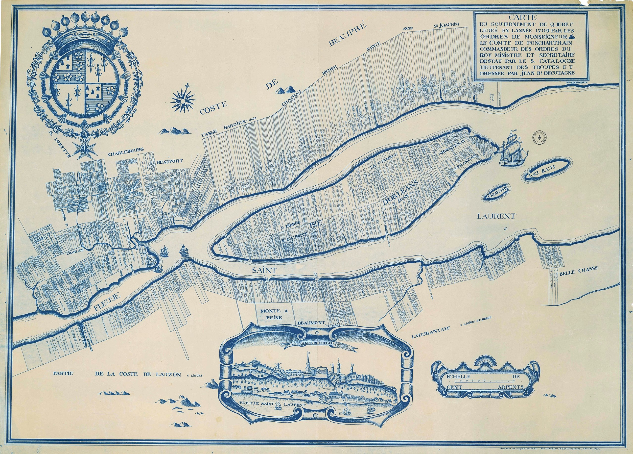
English: Cadastral map of Québec city region, 1709, from Bibliothèque et Archives nationales du Québec (BAnQ)
Français : Carte du gouvernement de Québec levée en l'année 1709 par les ordres de Monseigneur le Comte de Ponchartrain commandeur des ordres du Roy ministre et secrétaire d'estat / par le Sr. Catalogne lieutenant des troupes ; et dressée par Jean Bte Decoüagne |
| Date | |
| Source | http://arslanmb.org/fortier/Map-PQ-QuebecCityEnvirons-1709.jpg |
| Author | Gédéon de Catalogne |
Licensing
[edit]
|
This work is in the public domain in its country of origin and other countries and areas where the copyright term is the author's life plus 100 years or fewer. | |
| This file has been identified as being free of known restrictions under copyright law, including all related and neighboring rights. | |
File history
Click on a date/time to view the file as it appeared at that time.
| Date/Time | Thumbnail | Dimensions | User | Comment | |
|---|---|---|---|---|---|
| current | 19:48, 15 September 2016 | | 5,000 × 3,583 (2.86 MB) | Jeangagnon (talk | contribs) | {{Information |Description ={{en|1=Cadastral map of Québec city region, 1709, from Bibliothèque et Archives nationales du Québec (BAnQ)}} |Source =http://arslanmb.org/fortier/Map-PQ-QuebecCityEnvirons-1709.jpg |Author =Gédéon de... |
You cannot overwrite this file.
File usage on Commons
There are no pages that use this file.
File usage on other wikis
The following other wikis use this file:
- Usage on fr.wikipedia.org