File:Cadastral map of a portion of Feliciana District, Spanish West Florida. LOC 2013585064.jpg
Jump to navigation
Jump to search
Size of this preview: 800 × 540 pixels. Other resolutions: 320 × 216 pixels | 640 × 432 pixels | 1,024 × 692 pixels | 1,280 × 864 pixels | 2,560 × 1,729 pixels | 5,938 × 4,010 pixels.
Original file (5,938 × 4,010 pixels, file size: 2.93 MB, MIME type: image/jpeg)
Captions
Captions
Add a one-line explanation of what this file represents
Summary
[edit]| Description |
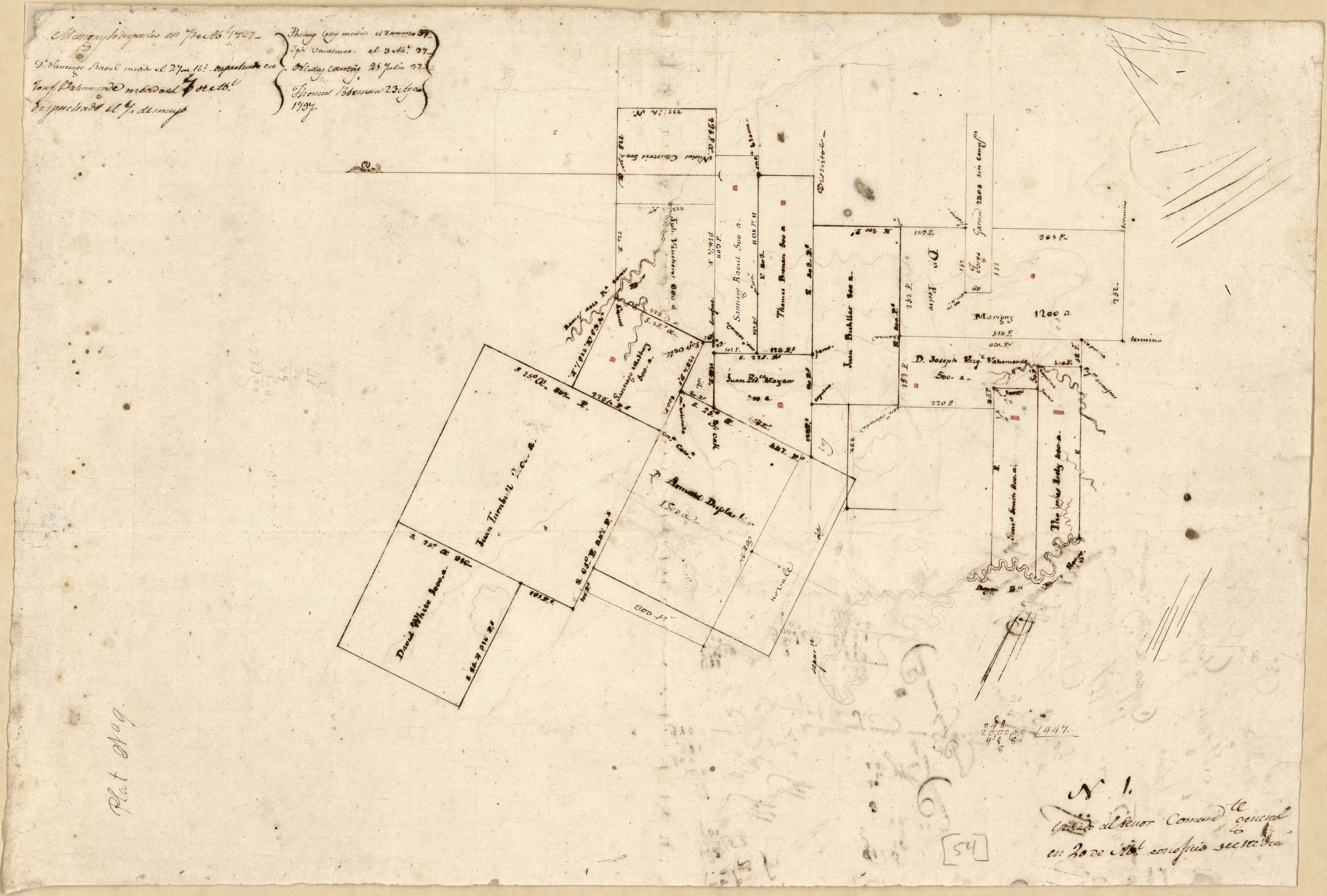
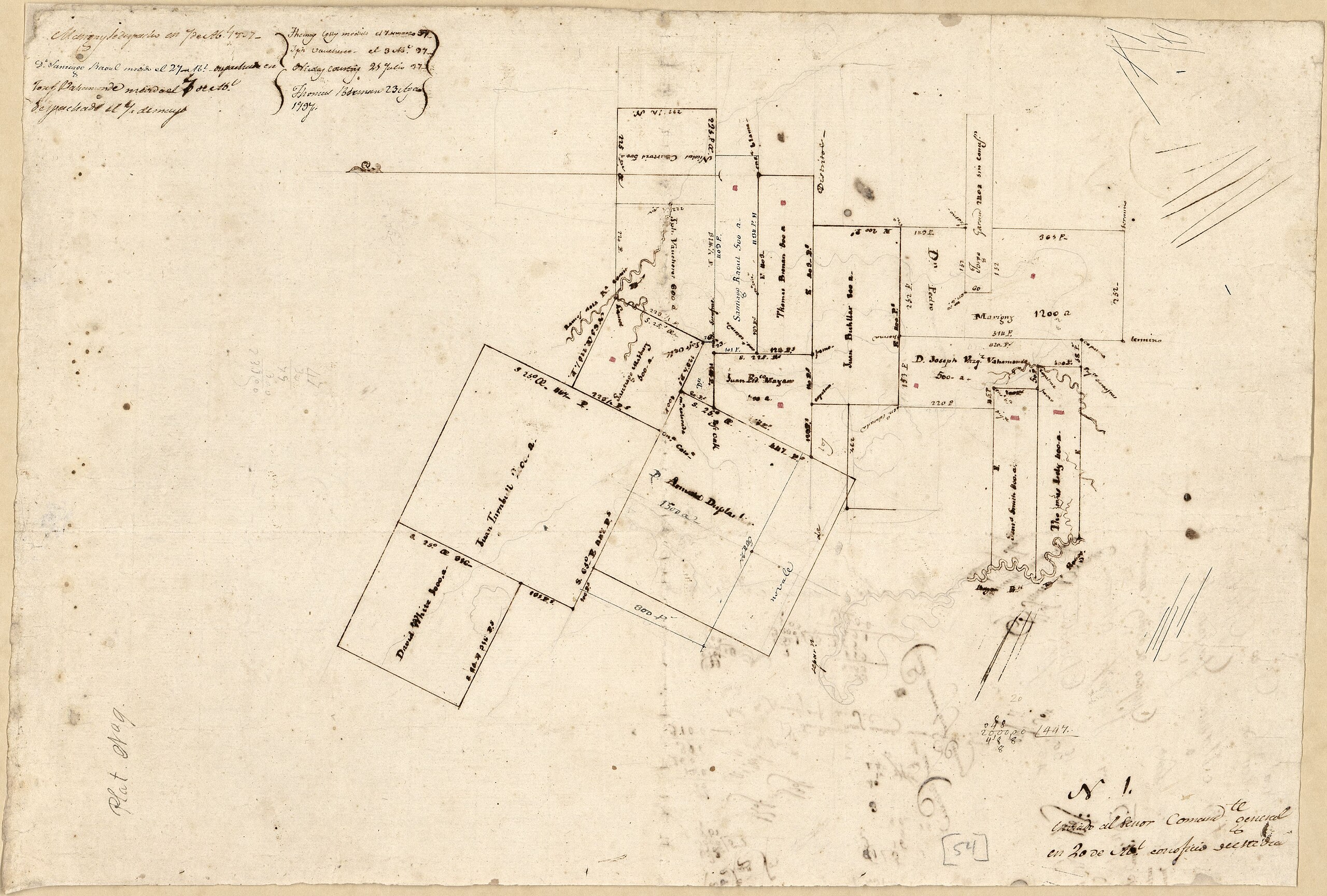
English: Title from John R. Hébert's list of maps. Notes in Spanish. Pen-and-ink, watercolor, and pencil; unfinished. Oriented with north to the left. Watermarks: Adriaana Rogge, horn in a shield surmounted by a crown over the letters GR, and other unidentified watermark. From the papers of Vicente Sebastián Pintado. Described in: Vicente Sebastián Pintado, Surveyor General of Spanish West Florida, 1805-17 : the man and his maps / by John R. Hébert. Imago mundi, v. 39, pp. 50-72. 1987. p. 70-71, no. 54. Includes notes. Annotations on verso. LC Luso-Hispanic World, 923 In lower right corner: N 1 enviado al Señor Comandte general en 20 de Abl conosicio de este dia. In lower left corner: Plat no 9. Available also through the Library of Congress Web site as a raster image. |
||
| Title | [Cadastral map of a portion of Feliciana District, Spanish West Florida]. | ||
| Shelf ID | G4013.W7G46 1805 .P5 | ||
| Date | |||
| Source | https://www.loc.gov/item/2013585064/ | ||
| Author | Pintado, Vicente Sebastián | ||
| Permission (Reusing this file) |
|
||
| Other versions |
|
||
| Location | West Feliciana Paris · United States · Lousiana · Louisiana · West Feliciana Parish | ||
| Part of | American Memory · Catalog · Geography And Map Division · Cultural Landscapes | ||
| Subject | West Feliciana Paris · West Feliciana Parish · Cadastral Maps · West Feliciana Parish (La.) · United States · Maps · Real Property · Louisiana · Manuscript Maps |


Licensing
[edit]
|
This is a faithful photographic reproduction of a two-dimensional, public domain work of art. The work of art itself is in the public domain for the following reason:
The official position taken by the Wikimedia Foundation is that "faithful reproductions of two-dimensional public domain works of art are public domain".
This photographic reproduction is therefore also considered to be in the public domain in the United States. In other jurisdictions, re-use of this content may be restricted; see Reuse of PD-Art photographs for details. | ||||
File history
Click on a date/time to view the file as it appeared at that time.
| Date/Time | Thumbnail | Dimensions | User | Comment | |
|---|---|---|---|---|---|
| current | 07:17, 9 June 2018 | | 5,938 × 4,010 (2.93 MB) | Fæ (talk | contribs) | LOC Maps https://www.loc.gov/item/2013585064/ #9395 |
You cannot overwrite this file.
File usage on Commons
The following 3 pages use this file:
._LOC_2013585064.jpg&redirect=no)