File:Caldor Fire Burn Scar (MODIS 2021-09-02).jpg

Original file (1,609 × 1,218 pixels, file size: 305 KB, MIME type: image/jpeg)
Captions
Captions
Summary
[edit].jpg&action=edit§ion=1)
| Description |
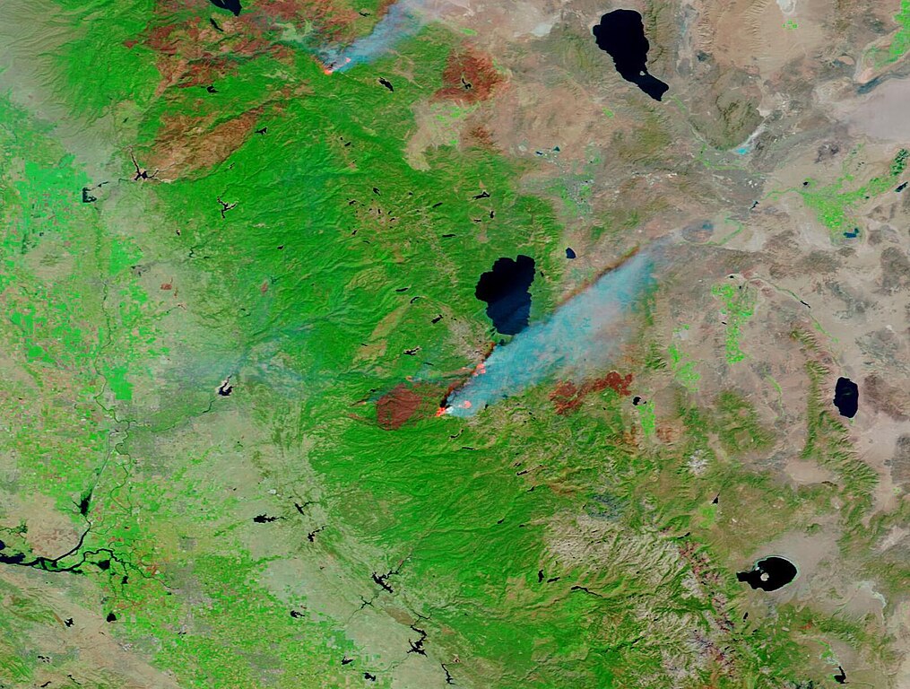
English: The 2021 fire season has proven excruciating for much of the United States, especially in California. On August 31, the National Interagency Fire Center reported that in the first eight months of this year, 42,647 fires had seared 4,879,574 acres across the county. While this is close to the ten-year average in the U.S., California’s statistics are beating the 5-year average in that state. According to CAL FIRE, as of August 30, 6,983 fires in California have scorched 1,887,773 acres. The 5-year average is 6,170 fires and 782011 acres.
Two of the California blazes have burned their way into the history books. According to news reports, both the Dixie Fire and the Caldor Fire have become the first two fires known to have crossed the ridge of the Sierra Nevada, burning from one side to the other. As of September 1, both fires have also made the top-twenty list of all-time largest California wildfires. The Dixie Fire, which started in July and continues to burn in Butte, Plumas, Lassen, and Tehama counties, has burnt 844,081 acres, to make it the second-largest fire in the state’s history. The Caldor Fire, with 207,931 acres affected in El Dorado County, ranks as number 15 for size. On August 28, the Moderate Resolution Imaging Spectroradiometer (MODIS) on board NASA’s Terra satellite acquired a false-color image highlighting the massive burn scar of the Caldor Fire. This type of image uses short-wave infrared, near-infrared, and red wavelengths (Bands 7,2,1) to contrast burn scars from vegetation. Here, vegetation appears bright green, open land appears in shades of tan, and water appears blue. Burn scars can be colored black, brown, or brick red, depending on the type of vegetation burned, the completeness of the burn, the amount of residue that remains, and the age of the burn. In this image, most of the freshly-burned land appears brick red and stands out in dramatic contrast against the green vegetation. Some areas of vegetation remain within the burn scar, indicating that these spots were at least partially spared from the flames. At the edge of the Caldor fire, bright orange “hot spots” can be seen. These are areas where the thermal bands on the MODIS instrument have detected high temperatures. Combined with typical smoke—as in this image—such hot spots mark actively burning fire. The blue lake to the northeast of the Caldor Fire is Lake Tahoe. Firefighters continue to try to turn the fire from communities on the southern end of Lake Tahoe as the fire moves closer to the resort area. According to local news reports, on August 30 about 22,000 residents of South Lake Tahoe jammed the main roads out of town after they were ordered to evacuate. Reports on September 1 suggest that firefighters have made progress in stalling the fire’s approach to the town but are still fighting gusty winds and extremely dry conditions. The cause of this fire, which ignited on August 14, is under investigation. The burn scar to the east of the Caldor Fire is from the Tamarack Fire, which ignited on July 4 from lightening. It has burned 68,637 acres and as of the last incident report on August 22 was 82 percent contained. The fire is showing minimal fire behavior and should be fully contained as of September 2. |
||
| Date | Taken on 29 August 2021 | ||
| Source |
Caldor Fire Burn Scar (direct link)
|
||
| Author | MODIS Land Rapid Response Team, NASA GSFC |
| This media is a product of the Terra mission Credit and attribution belongs to the mission team, if not already specified in the "author" row |
Licensing
[edit].jpg&action=edit§ion=2)
| This file is in the public domain in the United States because it was solely created by NASA. NASA copyright policy states that "NASA material is not protected by copyright unless noted". (See Template:PD-USGov, NASA copyright policy page or JPL Image Use Policy.) | ||
 |
Warnings:
|
File history
Click on a date/time to view the file as it appeared at that time.
| Date/Time | Thumbnail | Dimensions | User | Comment | |
|---|---|---|---|---|---|
| current | 18:48, 29 January 2024 | | 1,609 × 1,218 (305 KB) | OptimusPrimeBot (talk | contribs) | #Spacemedia - Upload of http://modis.gsfc.nasa.gov/gallery/images/image09022021_250m.jpg via Commons:Spacemedia |
You cannot overwrite this file.
File usage on Commons
There are no pages that use this file.
.jpg&oldid=856175787)