File:Cambridgeshire UK locator map 2010.svg
跳去導覽
跳去搵嘢

呢個「SVG」檔案嘅呢個「PNG」預覽嘅大細:494 × 600 像素。 第啲解像度:198 × 240 像素 | 395 × 480 像素 | 633 × 768 像素 | 843 × 1,024 像素 | 1,687 × 2,048 像素 | 1,108 × 1,345 像素。
原本檔案 (SVG檔案,表面大細: 1,108 × 1,345 像素,檔案大細:302 KB)
Captions
Captions
Add a one-line explanation of what this file represents
摘要
[編輯]
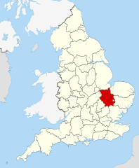
| 描述 | Location of the ceremonial county of Cambridgeshire within England. |
| 日期 | |
| 來源 |
National Geospatial-Intelligence Agency
|
| 作者 | Nilfanion |
協議
[編輯]
I, the copyright holder of this work, hereby publish it under the following licenses:
呢個檔案用共享創意 姓名標示-非商業性-相同方式分享3.0 未本地化版本條款授權。
- 你可以:
- 去分享 – 複製、發佈同傳播呢個作品
- 再改 – 創作演繹作品
- 要遵照下面嘅條件:
- 署名 – 你一定要畀合適嘅表彰、畀返指向呢個授權條款嘅連結,同埋寫明有無改過嚟。你可以用任何合理方式去做,但唔可以用任何方式暗示授權人認可咗你或者你嘅使用方式。
- 相同方式分享 – 如果你用任何方式改過呢個作品,你必須要用返原本或者相似嘅條款發佈。

|
根據自由軟體基金會發佈嘅無固定段落、封面文字同封底文字GNU自由文件授權條款第1.2或打後嘅版本,你獲授權可以重製、散佈同埋修改爾份文件。授權條款嘅副本喺章節GNU自由文件授權條款。 |
你可以揀你想用嘅牌照。

|
This is one of the images forming part of the Valued image set: Locator maps of the Ceremonial counties of England on Wikimedia Commons. The image set has been assessed under the valued image set criteria and is considered the most valued set on Commons within the scope:
Locator maps of the Ceremonial counties of England
You can see its nomination at Commons:Valued image candidates/Locator maps of English ceremonial counties. |
檔案歷史
撳個日期/時間去睇響嗰個時間出現過嘅檔案。
| 日期/時間 | 縮圖 | 尺寸 | 用戶 | 註解 | |
|---|---|---|---|---|---|
| 現時 | 2010年11月23號 (二) 22:31 | | 1,108 × 1,345(302 KB) | Nilfanion(傾偈 | 貢獻) | == Summary == {{Information |Description=Location of the ceremonial county of Cambridgeshire within England. |Source=Ordnance Survey [https://www.ordnancesurvey.co.uk/opendatadownload/products.html OpenData]: *Co |
你無得衾咗個檔案。
檔案用途
以下嘅34版用到呢個檔:
- Valued image set: Locator maps of the Ceremonial counties of England
- Commons:Valued image candidates/Locator maps of English ceremonial counties
- Category:Alumni by school in Cambridgeshire
- Category:Births in Cambridgeshire
- Category:Bridges in Cambridgeshire
- Category:Burials in Cambridgeshire
- Category:Cambridgeshire
- Category:Cambridgeshire in the 16th century
- Category:Cambridgeshire in the 19th century
- Category:Cambridgeshire in the 2000s
- Category:Cambridgeshire in the 2010s
- Category:Cambridgeshire in the 20th century
- Category:Cambridgeshire in the 21st century
- Category:Canals in Cambridgeshire
- Category:Castles in Cambridgeshire
- Category:Cemeteries in Cambridgeshire
- Category:Deaths in Cambridgeshire
- Category:Disused railway stations in Cambridgeshire
- Category:Hospitals in Cambridgeshire
- Category:Local government in Cambridgeshire
- Category:Maps of Cambridgeshire
- Category:Meadows in Cambridgeshire
- Category:Populated places in Cambridgeshire
- Category:Rail transport in Cambridgeshire
- Category:Railway stations in Cambridgeshire
- Category:Rivers of Cambridgeshire
- Category:Roads in Cambridgeshire
- Category:Sports venues in Cambridgeshire
- Category:Towers in Cambridgeshire
- Category:Tunnels in Cambridgeshire
- Category:Views of Cambridgeshire
- Category:Villages in Cambridgeshire
- Category:Visitor attractions in Cambridgeshire
- Category:Windmills in Cambridgeshire
全域檔案使用情況
下面嘅維基都用緊呢個檔案:
- af.wikipedia.org嘅使用情況
- an.wikipedia.org嘅使用情況
- ar.wikipedia.org嘅使用情況
- ast.wikipedia.org嘅使用情況
- be-tarask.wikipedia.org嘅使用情況
- bg.wikipedia.org嘅使用情況
- br.wikipedia.org嘅使用情況
- ca.wikipedia.org嘅使用情況
- ceb.wikipedia.org嘅使用情況
- cs.wikipedia.org嘅使用情況
- dag.wikipedia.org嘅使用情況
- en.wikipedia.org嘅使用情況
- Cambridgeshire
- Eye Green
- Paxton Pits Nature Reserve
- Northborough, Cambridgeshire
- Carlton, Cambridgeshire
- Cambridge Business Park
- Brinkley, Cambridgeshire
- Rivey Hill
- Newmarket Ridge
- Free School Lane
- Odsey
- New England, Peterborough
- Westwick, Cambridgeshire
- Upend
- Upton, Peterborough
- Denton and Caldecote
- The Stukeleys
- Template:Cambridgeshire-geo-stub
- Stanground North
- Bainton, Cambridgeshire
- Barham and Woolley
- Old Fletton Urban District
- Queen Adelaide, Cambridgeshire
- Bythorn and Keyston
- Netherton, Peterborough
- Conington, South Cambridgeshire
- Serpentine Green
- Chettisham
- Doddington, Cambridgeshire
- Wothorpe
- Stamford Baron St Martin
- St Martin's Without
- Little Downham
- Coveney, Cambridgeshire
- Glinton, Cambridgeshire
- Melbourn Science Park
睇呢個檔案嘅更多全域使用情況。