File:Canada's Coast Mountain (MODIS 2021-01-01).jpg
Jump to navigation
Jump to search
Size of this preview: 731 × 600 pixels. Other resolutions: 293 × 240 pixels | 585 × 480 pixels | 936 × 768 pixels | 1,248 × 1,024 pixels | 2,496 × 2,048 pixels | 5,667 × 4,650 pixels.
Original file (5,667 × 4,650 pixels, file size: 5.08 MB, MIME type: image/jpeg)
Captions
Captions
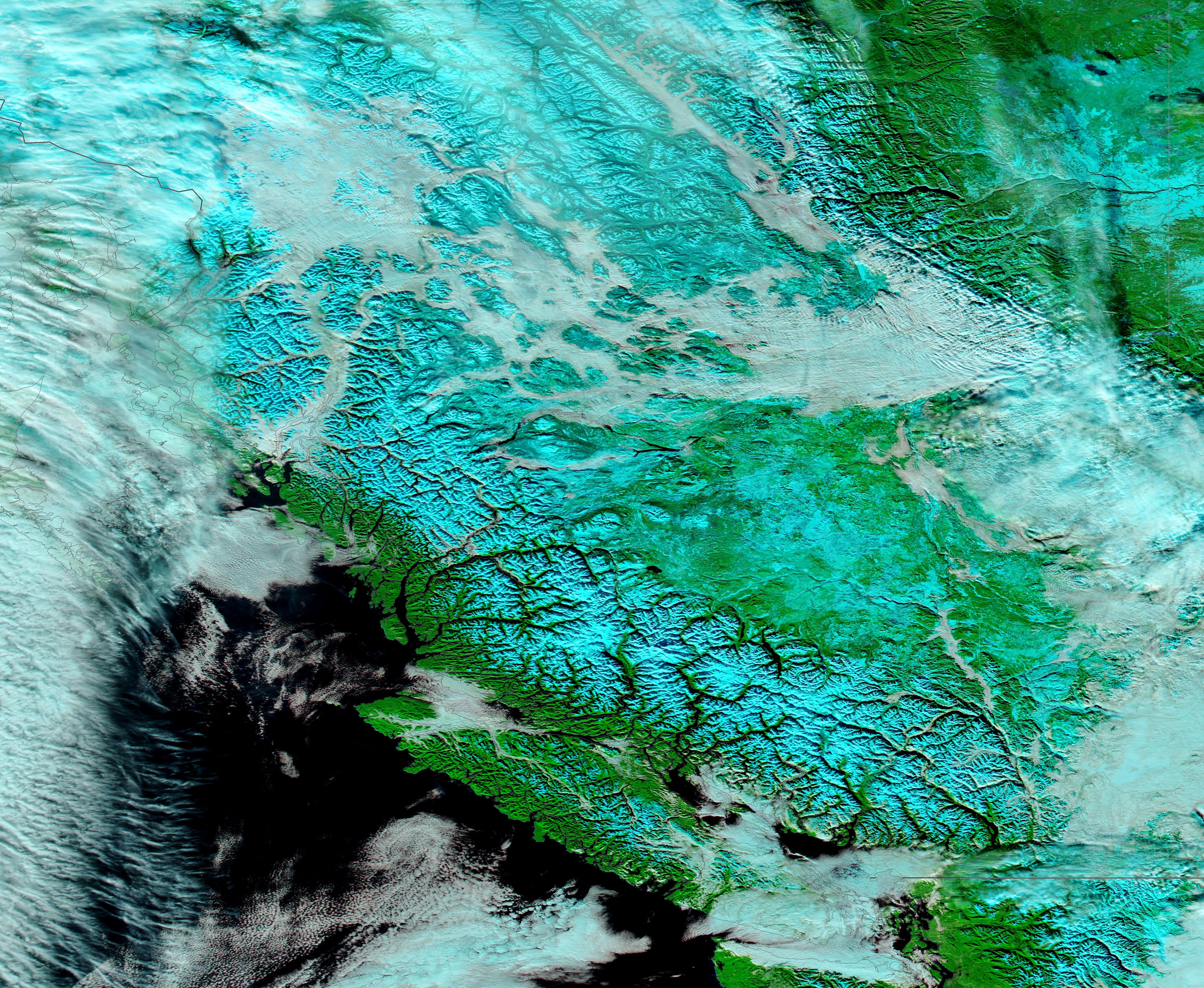
Snow and clouds covered Canada’s Coast Mountains on December 28, 2020 when the Moderate Resolution Imaging Spectroradiometer (MODIS) on board NASA’s Terra satellite acquired a false-color image of the scene.
Summary
[edit].jpg&action=edit§ion=1)
| Description |
English: Snow and clouds covered Canada’s Coast Mountains on December 28, 2020 when the Moderate Resolution Imaging Spectroradiometer (MODIS) on board NASA’s Terra satellite acquired a false-color image of the scene.
The Coast Mountains run roughly parallel to the coastline of the Pacific Ocean, stretching from Yukon, Alaska (United States of America) to the Fraser River in southern British Colombia, Canada. They are part of the group called the “American Cordillera”, a nearly unbroken series of mountain ranges that run along the west of North America, Central America, South America, and even Antarctica. Snow blankets the Coast Mountains in winter but snow can fall at nearly any time of the year in the highest peaks. By December, snow lies thick on the entire mountain range and clouds are frequent. In these conditions, when white cloud overlies white snow, it can be difficult to distinguish between the two with true-color images. However, by using false-color (bands 7,2,1), cloud and snow are easy to tell apart. In this combination vegetation appears bright green, deep water looks black and snow appears electric blue. Cloud appears white, just as in true-color images, unless the clouds are very cold and contain ice crystals. In this case, the cloud will have an electric-blue tint. Low cloud (fog) typically has a light gray tint and sits within mountain valleys. |
||
| Date | Taken on 28 December 2020 | ||
| Source |
Canada's Coast Mountain (direct link)
|
||
| Author | MODIS Land Rapid Response Team, NASA GSFC |
| This media is a product of the Terra mission Credit and attribution belongs to the mission team, if not already specified in the "author" row |
Licensing
[edit].jpg&action=edit§ion=2)
| This file is in the public domain in the United States because it was solely created by NASA. NASA copyright policy states that "NASA material is not protected by copyright unless noted". (See Template:PD-USGov, NASA copyright policy page or JPL Image Use Policy.) | ||
 |
Warnings:
|
File history
Click on a date/time to view the file as it appeared at that time.
| Date/Time | Thumbnail | Dimensions | User | Comment | |
|---|---|---|---|---|---|
| current | 18:09, 30 January 2024 | | 5,667 × 4,650 (5.08 MB) | OptimusPrimeBot (talk | contribs) | #Spacemedia - Upload of http://modis.gsfc.nasa.gov/gallery/images/image01012021_250m.jpg via Commons:Spacemedia |
You cannot overwrite this file.
File usage on Commons
There are no pages that use this file.
.jpg&oldid=847252966)