File:Canada (MODIS 2018-06-02).jpg

Original file (4,831 × 4,016 pixels, file size: 1.82 MB, MIME type: image/jpeg)
Captions
Captions
Summary
[edit].jpg&action=edit§ion=1)
| Description |
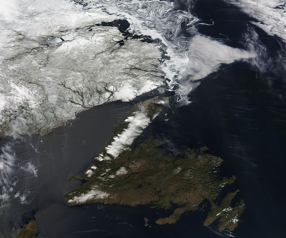
English: Snow and sea ice dominated the scenery in northeastern Canada in late May 2018. The Moderate Resolution Imaging Spectroradiometer (MODIS) aboard NASA’s Terra satellite acquired a true-color image of the still-wintery scene on May 28.
The southeastern section of the island of Newfoundland appears free of snow, but the Great Northern Peninsula and the higher elevations near Cabot Strait, in the southwest, remain covered in white. Filigrees of sea ice curl off the coast of the province of Labrador-Newfoundland and across the Labrador Sea. Tendrils of sea ice also float in Baffin Bay between the island of Newfoundland and the mainland. According to the government of Canada, on June 1, the first ice edge was estimated from Newfoundland near 5030N 5615W to 5020N5505W to 5125N 5105W to 5500N 5155W to 5800N 5730W then northward, with sea ice west of the ice edge. The second ice edge was estimated from Quebec near 5125N 5710W to Newfoundland near 5105N 5650W. Sea ice north of the ice edge. The ice coverage was described as primarily bergy water with 2 tenths first-year ice, including a trace of old ice in the extreme northeastern section. Sea ice is typically present off the northeastern coast of Canada from mid-January to early May. As the ice melts, icebergs begin to drift eastward in a summer migration. On the island of Newfoundland, iceberg spotting becomes a passion for many residents and tourists by late springtime as ‘bergs pass close to the coast. The location of passing icebergs are followed by fans on social media and the web, giving the drifting chunks of ice near-star status. A Facebook page, Newfoundland Iceberg Reports, shares photos and up-to-the minute sightings and tips for viewing individual icebergs, while https://icebergfinder.com/ is a map-based locator. On June 1, icebergfinder.com lists 34 icebergs adrift off of Newfoundland and encourages iceberg tourism with the slogan “It took them 10,000 years to pay us a visit. We suggest you don’t wait that long”. |
||
| Date | Taken on 28 May 2018 | ||
| Source |
|
||
| Author | Jeff Schmaltz, MODIS Land Rapid Response Team, NASA GSFC |
| This media is a product of the Terra mission Credit and attribution belongs to the mission team, if not already specified in the "author" row |
Licensing
[edit].jpg&action=edit§ion=2)
| This file is in the public domain in the United States because it was solely created by NASA. NASA copyright policy states that "NASA material is not protected by copyright unless noted". (See Template:PD-USGov, NASA copyright policy page or JPL Image Use Policy.) | ||
 |
Warnings:
|
File history
Click on a date/time to view the file as it appeared at that time.
| Date/Time | Thumbnail | Dimensions | User | Comment | |
|---|---|---|---|---|---|
| current | 01:43, 17 February 2024 | | 4,831 × 4,016 (1.82 MB) | OptimusPrimeBot (talk | contribs) | #Spacemedia - Upload of http://modis.gsfc.nasa.gov/gallery/images/image06022018_250m.jpg via Commons:Spacemedia |
You cannot overwrite this file.
File usage on Commons
There are no pages that use this file.
.jpg&oldid=852709531)