File:Cape Bab el-Mandeb Anglo-Turkish Demarcation Line.jpg
Jump to navigation
Jump to search

Size of this preview: 576 × 599 pixels. Other resolutions: 231 × 240 pixels | 461 × 480 pixels | 738 × 768 pixels | 984 × 1,024 pixels | 1,385 × 1,441 pixels.
Original file (1,385 × 1,441 pixels, file size: 435 KB, MIME type: image/jpeg)
Captions
Captions
Add a one-line explanation of what this file represents
Summary
[edit]
| Description |
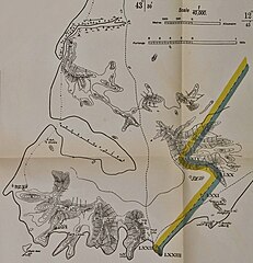
English: Map showing the Anglo-Turkish demarcation line of the Cape Bab el-Mandeb area in Yemen, also know as Sheikh Said and now generally known as Ras Menheli. This separate map was part of a larger map issued as an annex to the Anglo-Turkish Convention of 3 June 1914. This larger map of the southwestern tip of the Arabian Peninsula showed the demarcation line agreed upon between 1902 and 1904 by the Anglo-Turkish Boundary Commission which had been tasked to demarcate the respective Ottoman and British spheres of influence in South Arabia. |
| Date | |
| Source | Qatar Digital Library |
| Author | British War Office/Survey of India |
Licensing
[edit]
|
This work is in the public domain in its country of origin and other countries and areas where the copyright term is the author's life plus 100 years or fewer. | |
| This file has been identified as being free of known restrictions under copyright law, including all related and neighboring rights. | |
File history
Click on a date/time to view the file as it appeared at that time.
| Date/Time | Thumbnail | Dimensions | User | Comment | |
|---|---|---|---|---|---|
| current | 22:22, 18 November 2015 | | 1,385 × 1,441 (435 KB) | Lubiesque (talk | contribs) | User created page with UploadWizard |
You cannot overwrite this file.
File usage on Commons
The following page uses this file: