File:Carte de Provence et des Terres Adjacentes (MAPS 123).jpg

Original file (7,308 × 5,798 pixels, file size: 12.6 MB, MIME type: image/jpeg)
Captions
Captions
|
|
|
This image was automatically transferred from the collections of the University of Washington. While certainly the majority of metadata in their database is correct, it is not necessarily written by individuals who are expert on the material they are describing. Such images often have incorrect dates, locations, or other information. If you can verify that this information is correct, or correct it if it isn't, please do so and remove this template. Also, if you are correcting information, please also let the library know so that they can update the metadata on their site. You can contact UW LIBRARIES MSCUA at photos |
Summary
[edit]| Title |
English: Carte de Provence et des Terres Adjacentes |
|||||||||||||||||||||||
| Description |
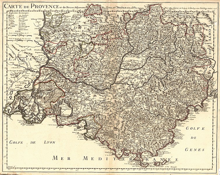
English: Copperplate engraving. Outline color. Relief shown pictorially. Printed between top neat lines: " Carte de Provence et des Terres Adjacentes Par Guillaume DelIsle de l'Academie Rle. Des Sciences A Paris Chez l'Auteur sur le Quay de l'Horloge avec Privilege Octobre 1715." Printed in upper left is a key explaining symbols used in map for cities, villages, towns, parishes, abbeys, chapels, castles, and more. Key also explains abbreviations for principality, duchy, land owned by a marquis, county, land owned by a viscount, barony, adjoining land, Roman roads and other roads. Printed in upper left corner is a scale comparing common French leagues and leagues of Provence. Printed in lower left corner: "Derozier Sc." Written in ink in upper right corner: "No. 44." Depicts Provence as well as parts of the neighboring regions including Languedoc to the west and Nice to the east. Also shows the Gulf of Lyon, the Gulf of Genoa, the Rhone River and the Durance River. Scale: c.a. 1:415,000.Guillaume de L'Isle (1675-1726) was a cartographer and the Premier Geographer to the King in France beginning in 1718. His family played a significant part in the world of French cartography in the eighteenth century. At age 9, he drew his first map and at age 27 he became a member of the Académie Royale des Sciences. He studied under Jacques Cassini, acquiring knowledge in both mathematics and astronomy. Due to his academic background and his "critical approach to the maps of his predecessors," he became known as the first "scientific cartographer" (Moreland and Bannister, 132). Among his works are "Globe, map of the world and the four continents" (1700), "Atlas de Géographie" (1700-12), "Mississippi" (1701), "Carte du Mexique et de la Floride…" (c.a. 1703), "Carte de la Louisiane et du Mississippi" (1718) and posthumously, "Atlas Noveau" (1730 and later). Following his death, his widow took up the business with a partner, Philippe Buache (Tooley 395; Moreland and Bannister, 131-2). This particular map was separated from a pre-1732 copy of Guillaume de L'Isle's "Atlas de Geographie." Source(s): David Rumsey Cartography Associates. "David Rumsey Collection: Carte de Provence et des terres adjacentes. Par Guillaume delIsle, Pre." Accessed 20 Mar 2009. Moreland, Carl and David Bannister. "Antique Maps: A Collector's Handbook." New York: Longman Group, Ltd., 1983. Tooley, Ronald Vere. "Tooley's Dictionary of Mapmakers." Hertfordshire: Map Collector Publications Limited, 1979.
|
|||||||||||||||||||||||
| Publisher | L'Isle, Guillaume de 1675-1726 | |||||||||||||||||||||||
| Digital ID Number | MAP029 | |||||||||||||||||||||||
| Condition | Has binder's guard and watermark. Water damage on lower left corner of sheet. Some browning around edges. Slight darkening along centerfold. | |||||||||||||||||||||||
| Date | ||||||||||||||||||||||||
| Source |
English: World and Regional Maps Collection |
|||||||||||||||||||||||
| Creator |
English: Desrosiers |
|||||||||||||||||||||||
| Permission (Reusing this file) |
|
|||||||||||||||||||||||
| Geotemporal data | ||||||||||||||||||||||||
| Map location | Provence | |||||||||||||||||||||||
| Georeferencing | If inappropriate please set warp_status = skip to hide. | |||||||||||||||||||||||
| Bibliographic data | ||||||||||||||||||||||||
| Publication |
"Atlas de Geographie." L'Isle, Guillaume de. Paris: Guillaume de L'Isle, pre-1732. |
|||||||||||||||||||||||
| Place of publication | Paris | |||||||||||||||||||||||
| Archival data | ||||||||||||||||||||||||
| Collection |
|
|||||||||||||||||||||||
| Accession number | ||||||||||||||||||||||||
| Medium |
English: G5833 P7 1715 L5 |
|||||||||||||||||||||||


.jpg&action=edit§ion=1)
File history
Click on a date/time to view the file as it appeared at that time.
| Date/Time | Thumbnail | Dimensions | User | Comment | |
|---|---|---|---|---|---|
| current | 05:27, 8 July 2022 | | 7,308 × 5,798 (12.6 MB) | BMacZeroBot (talk | contribs) | Batch upload (Commons:Batch uploading/University of Washington Digital Collections) |
You cannot overwrite this file.
File usage on Commons
There are no pages that use this file.
.jpg&oldid=849199013)