File:Carte de la partie de la côte de Barbarie comprise entre le cap Negro et le cap Bujarone - par M. le marquis de Chabert - btv1b53237617x (1 of 2).jpg
Jump to navigation
Jump to search

Size of this preview: 800 × 565 pixels. Other resolutions: 320 × 226 pixels | 640 × 452 pixels | 1,024 × 723 pixels | 1,280 × 903 pixels | 2,560 × 1,807 pixels | 7,817 × 5,517 pixels.
Original file (7,817 × 5,517 pixels, file size: 5.52 MB, MIME type: image/jpeg)
Captions
Captions
Add a one-line explanation of what this file represents
Summary[edit]
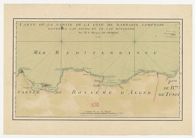
| Carte de la partie de la côte de Barbarie comprise entre le cap Negro et le cap Bujarone / par M. le marquis de Chabert
( |
|||||||||||||||||||||||||||
|---|---|---|---|---|---|---|---|---|---|---|---|---|---|---|---|---|---|---|---|---|---|---|---|---|---|---|---|
| Author |
Chabert, Joseph-Bernard de (1724-1805). Cartographe |
||||||||||||||||||||||||||
| Title |
Carte de la partie de la côte de Barbarie comprise entre le cap Negro et le cap Bujarone / par M. le marquis de Chabert |
||||||||||||||||||||||||||
| Description |
Français : Sujet : Sondages sous-marins
El Qoll Fer, Cap de Annaba Takouch, Ras (cap) Garde, Cap de Cap Negro Cap Rose El Kala Tabarka, Île de Bougaroun, Cap La Galite, Île de Alger, Régence d' -- Côtes Tunis, Régence de Méditerranée, Mer Échelle(s) : [Echelle de] 10 lieues de 20 au degré [= 9,5 cm] Couverture : Mer Méditerranée Algérie Tunisie Langue : français |
||||||||||||||||||||||||||
| Date | 1774 | ||||||||||||||||||||||||||
| Dimensions | height: 48 cm (18.8 in); width: 33 cm (12.9 in) | ||||||||||||||||||||||||||
| Collection |
|
||||||||||||||||||||||||||
| References |
Français : Notice de recueil : http://catalogue.bnf.fr/ark:/12148/cb46930930w
Appartient à : [Division 2 du portefeuille 106 du Service hydrographique de la Marine consacrée aux cartes des côtes du cap Noé au golfe de Bizerte] ; 10 D Notice du catalogue : http://catalogue.bnf.fr/ark:/12148/cb46932841r |
||||||||||||||||||||||||||
| Source/Photographer |
Français : Bibliothèque nationale de France, département Cartes et plans, GE SH 18 PF 106 DIV 2 P 10 D
Bibliothèque nationale de France (1/2) |
||||||||||||||||||||||||||
| Permission (Reusing this file) |
|
||||||||||||||||||||||||||

.jpg&action=edit§ion=1)
File history
Click on a date/time to view the file as it appeared at that time.
| Date/Time | Thumbnail | Dimensions | User | Comment | |
|---|---|---|---|---|---|
| current | 19:04, 12 August 2022 | | 7,817 × 5,517 (5.52 MB) | Gzen92Bot (talk | contribs) | Gallica btv1b53237617x |
You cannot overwrite this file.
File usage on Commons
The following page uses this file:
.jpg)
File usage on other wikis
The following other wikis use this file:
- Usage on fr.wikipedia.org
.jpg&oldid=849217298)