File:Cartouche Kursk 1792.jpg
Jump to navigation
Jump to search
Size of this preview: 744 × 600 pixels. Other resolutions: 298 × 240 pixels | 596 × 480 pixels | 953 × 768 pixels | 1,271 × 1,024 pixels | 2,034 × 1,639 pixels.
Original file (2,034 × 1,639 pixels, file size: 5.05 MB, MIME type: image/jpeg)
Captions
Captions
Add a one-line explanation of what this file represents
| Description |
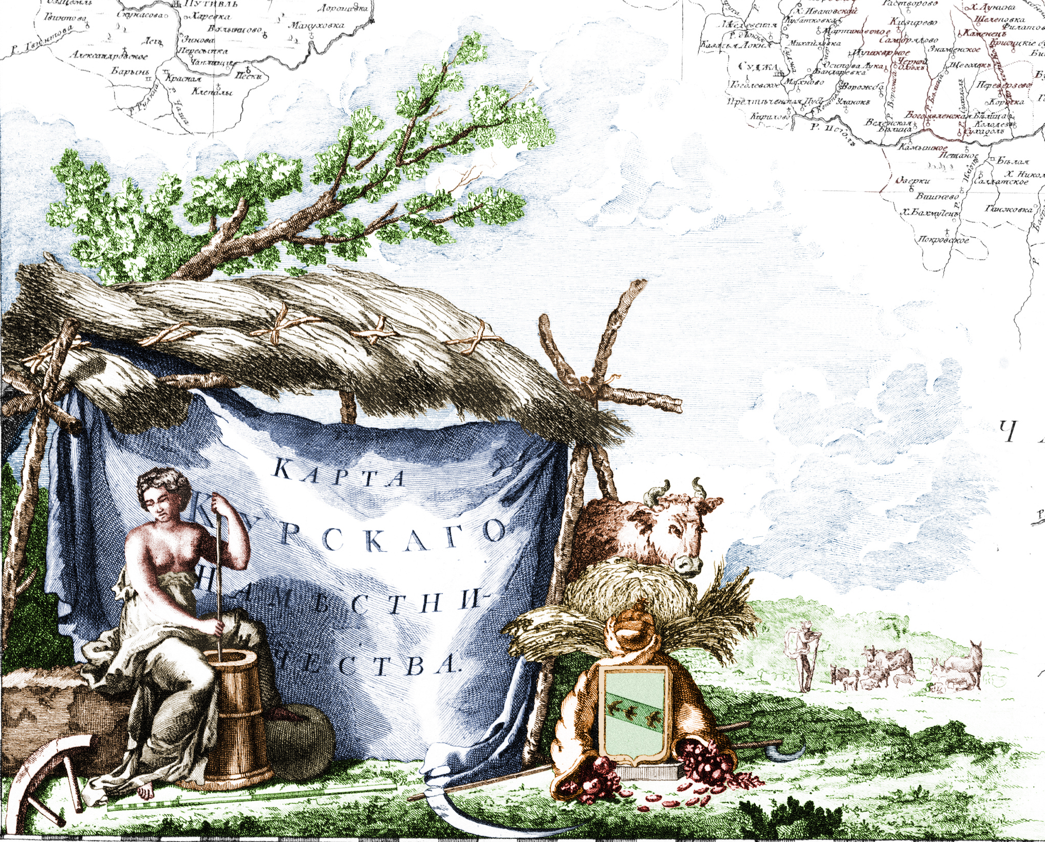
Русский: Картуш карты Курского наместничества (лист 24) из «Российского атласа из сорока четырех карт состоящего и на сорок на два наместничества Империю разделяющего» (1792). Находится в левом нижнем углу карты. Сюжет отражает сельскохозяйственное направление экономики наместничества. В композиции использованы рисунки, сиволизирующие сельское хозяйство: снопы, корова, выглядывающая из под навеса, пасущееся стадо. Губерния представлена в виде полуобнаженной женщины в античной одежде, сбивающей масло в маслобойке. Герб губернии обрамлён двумя рогами изобилия, символизирующих «чрезвычайное изобилие богатств и плодов земных», венчает герб держава — знак «промысла или провидения Божия». Описание дано по: Финягина Н.П. Сюжетные картуши Российского атласа 1792 года. — М.:Государственный исторический музей, 2006 — 128 c. — ISBN 5-89076-127-7
English: Cartouche of the map of Kursk Namestnichestvo (sheet 24) from official Atlas of the Russian Empire (1792). Cartouche symbolized agriculture as main economic sector of namestnichestvo. |
| Date | |
| Source |
Русский: Картуш вырезан из карты Курского наместничества, входящей в «Российский атлас, из сорока четырех карт состоящий и на сорок два наместничества империю разделяющий / Сочин., гравир. и печатан при Горном училище в 1792 г. Соч. А. Вильдбрехт. Гравир. А. Савинков, И. Леонов. Вырез. Т. Михайлов.» English: this image is extracted from map of Kursk Namestnichestvo fro atlas of the Russian Empire (1792) |
| Author | Unknown author |
| Other versions |
this image is extracted from map of Kursk Namestnichestvo:
|
.jpg)

|
This work is in the public domain in its country of origin and other countries and areas where the copyright term is the author's life plus 100 years or fewer. | |
| This file has been identified as being free of known restrictions under copyright law, including all related and neighboring rights. | |
File history
Click on a date/time to view the file as it appeared at that time.
| Date/Time | Thumbnail | Dimensions | User | Comment | |
|---|---|---|---|---|---|
| current | 09:09, 8 May 2011 | | 2,034 × 1,639 (5.05 MB) | Transcend (rus) (talk | contribs) | {{Information |Description={{ru|Картуш карты Курского наместничества (лист 24) из «Российского атласа из сорока четырех карт состоящего и на сорок на два н |
You cannot overwrite this file.
File usage on Commons
The following page uses this file:
File usage on other wikis
The following other wikis use this file:
- Usage on de.wikipedia.org
- Usage on ru.wikipedia.org