File:Cascadia earthquake sources.png
ナビゲーションに移動
検索に移動
高解像度版はありません。
Cascadia_earthquake_sources.png (580 × 575 ピクセル、ファイルサイズ: 25キロバイト、MIME タイプ: image/png)
キャプション
キャプション
このファイルの内容を1行で記述してください
概要
[編集]
| 解説 |
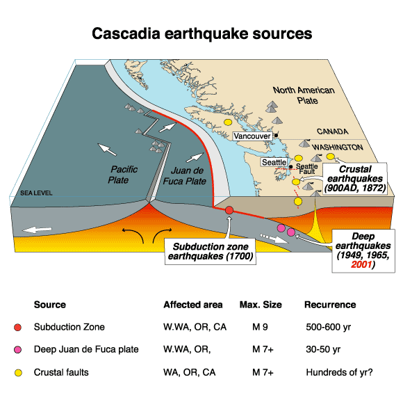
English: The Cascadia Earthquake. |
| 日付 | 2007年7月18日 (当初のアップロード日) |
| 原典 | https://geomaps.wr.usgs.gov/pacnw/pacnweq/pdf/subd_eqpg.pdf |
| 作者 |
オリジナルのアップロード者は英語版ウィキペディアのArgさん. Later versions were uploaded by Remember the dot at en.wikipedia. |
ライセンス
[編集]
この画像およびメディアは、アメリカ合衆国内務省の実務機関であるアメリカ地質調査所に属する者が職務上作成した著作物のみで構成されているため、アメリカ合衆国国内でパブリックドメインの状態にあります。詳細についてはUSGSの著作物に関する取扱い(英語)をご覧ください。
|
元のアップロードログ
[編集]
元のファイルページはこちら。以下の利用者は全てen.wikipediaに属します。
- 2007-07-18 20:41 Remember the dot 580×575×8 (26101 bytes) removed border and US government markings
- 2007-07-18 20:38 PNG crusade bot 582×577×8 (27100 bytes) == Summary == The Cascadia Earthquake To replace an inferior-quality jpeg version of this file in Cascadia_earthquake.jpeg {{PD-USGov-Interior-USGS}} Got from [http://wrgis.wr.usgs.gov/wgmt/pacnw/pacnweq/casceq.html], a US government site (note: page moved, new address is http://geomaps.wr.usgs.gov/pacnw/pacnweq/casceq.html). =
Automatically converted to PNG
[編集]
The PNG crusade bot automatically converted this image to the more efficient en:PNG format. The image was previously uploaded as "Cascadia earthquake.gif".
Previous file history
[編集]
- 15:32:18, 28 April 2007 (UTC) . . Arg (Talk | contribs) . . 582x577 (35,329 bytes) (The Cascadia Earthquake To replace an inferior-quality jpeg version of this file in Cascadia_earthquake.jpeg Got from [http://wrgis.wr.usgs.gov/wgmt/pacnw/pacnweq/casceq.html], a US government site. )
Previous description history
[編集]
- 18:04:58, 12 July 2007 (UTC) Remember the dot (Talk | contribs) (ShouldBePNG)
- 15:32:18, 28 April 2007 (UTC) Arg (Talk | contribs) (The Cascadia Earthquake To replace an inferior-quality jpeg version of this file in Cascadia_earthquake.jpeg Got from [http://wrgis.wr.usgs.gov/wgmt/pacnw/pacnweq/casceq.html], a US government site.)
ファイルの履歴
過去の版のファイルを表示するには、その版の日時をクリックしてください。
| 日付と時刻 | サムネイル | 寸法 | 利用者 | コメント | |
|---|---|---|---|---|---|
| 現在の版 | 2007年9月23日 (日) 16:24 | | 580 × 575 (25キロバイト) | TCY (トーク | 投稿記録) | {{Information |Description=__NOTOC__ == Summary == The Cascadia Earthquake To replace an inferior-quality jpeg version of this file in Cascadia_earthquake.jpeg Got from [http://wrgis.wr.usgs.gov/wgmt/pacnw/pacnweq/casceq.html], a US government site. |
このファイルは上書きできません。
ファイルの使用状況
以下の 3 ページがこのファイルを使用しています:
グローバルなファイル使用状況
以下に挙げる他のウィキがこの画像を使っています:
- ar.wikipedia.org での使用状況
- ca.wikipedia.org での使用状況
- cs.wikipedia.org での使用状況
- de.wikipedia.org での使用状況
- en.wikipedia.org での使用状況
- en.wikibooks.org での使用状況
- fr.wikipedia.org での使用状況
- it.wikipedia.org での使用状況
- ja.wikipedia.org での使用状況
- ko.wikipedia.org での使用状況
- mk.wikipedia.org での使用状況
- uk.wikipedia.org での使用状況
- vi.wikipedia.org での使用状況
- zh.wikipedia.org での使用状況
カテゴリ:
- Maps of Cascadia Subduction Zone
- Maps of subduction zones
- Block diagrams (cartography)
- Maps of earthquakes in North America
- Geography of British Columbia
- Geography of Washington (state)
- Volcanology of the United States
- Diagrams of the Cascade Range
- Geology of British Columbia
- Earthquakes in British Columbia
- Geology of Washington (state)
- Earthquakes in Washington (state)