File:Castell Cricieth o'r awyr yn 2023 - Cricieth Castle from a drone - Welsg built castle in Gwynedd, Wales 27.jpg
Jump to navigation
Jump to search

Size of this preview: 800 × 450 pixels. Other resolutions: 320 × 180 pixels | 640 × 360 pixels | 1,024 × 576 pixels | 1,280 × 720 pixels | 2,560 × 1,440 pixels | 4,032 × 2,268 pixels.
Original file (4,032 × 2,268 pixels, file size: 3.89 MB, MIME type: image/jpeg)
Captions
Captions
Add a one-line explanation of what this file represents
Summary
[edit]
| Description |
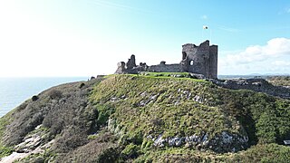
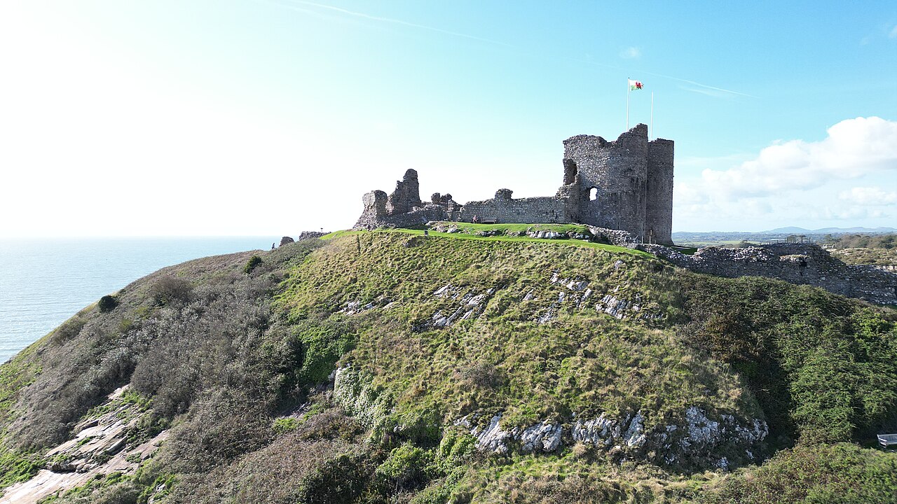
Cymraeg: Castell Cricieth o'r awyr yn 2023.
Wicipedia: Castell canoloesol Cymreig yw Castell Cricieth, sy'n sefyll ar glogwyn ar lan Bae Tremadog, ar ymyl tref Cricieth, Gwynedd, yng ngogledd Cymru. Mae gan y castell dŷ porth cadarn a thri thŵr a gysylltir gan fur amgylchynnol. Mae wedi'i gofrestru gan fel Gradd 1.English: Castell Cricieth is a Welsh built castle, built to keep out the English (Norman) invaders from Wales.
WP: Criccieth Castle is a 13c castle located in Cricieth, Gwynedd, Wales. It is located on a rocky headland overlooking Tremadog Bay and consists of an inner ward almost surrounded by an outer ward. The twin-towered inner gatehouse is the most prominent remaining feature and survives to almost its full height, as does the inner curtain wall. The castle was begun in the 1230s by Llywelyn ap Iorwerth, the prince of Gwynedd, who built the inner ward and gatehouse. It was extended by his grandson, Llywelyn ap Gruffudd, who constructed the outer ward.
|
||
| Date | |||
| Source | Own work | ||
| Author | Llywelyn2000 |
| Camera location | | View this and other nearby images on: OpenStreetMap |
|---|
Licensing
[edit]
I, the copyright holder of this work, hereby publish it under the following license:
This file is licensed under the Creative Commons Attribution-Share Alike 4.0 International license.
- You are free:
- to share – to copy, distribute and transmit the work
- to remix – to adapt the work
- Under the following conditions:
- attribution – You must give appropriate credit, provide a link to the license, and indicate if changes were made. You may do so in any reasonable manner, but not in any way that suggests the licensor endorses you or your use.
- share alike – If you remix, transform, or build upon the material, you must distribute your contributions under the same or compatible license as the original.

|
This image was uploaded as part of Wiki Loves Monuments 2023.
|
File history
Click on a date/time to view the file as it appeared at that time.
| Date/Time | Thumbnail | Dimensions | User | Comment | |
|---|---|---|---|---|---|
| current | 17:11, 5 September 2023 | | 4,032 × 2,268 (3.89 MB) | Llywelyn2000 (talk | contribs) | Uploaded own work with UploadWizard |
You cannot overwrite this file.
File usage on Commons
There are no pages that use this file.
File usage on other wikis
The following other wikis use this file:
- Usage on cy.wikipedia.org