File:Caucasiamapussr.gif
পরিভ্রমণে চলুন
অনুসন্ধানে চলুন
এর চেয়ে বেশি রেজোলিউশন লভ্য নয়।
Caucasiamapussr.gif (৭০০ × ৫৯০ পিক্সেল, ফাইলের আকার: ৮১ কিলোবাইট, এমআইএমই ধরন: image/gif)
ক্যাপশনসমূহ
ক্যাপশন
এই ফাইল কি প্রতিনিধিত্ব করছে তার এক লাইন ব্যাখ্যা যোগ করুন

|
File:Soviet Caucasus map.svg এই ফাইলের একটি ভেক্টর সংস্করণ। যখন উচ্চতর তখন এটি এই রাস্টার চিত্রের জায়গায় ব্যবহার করা উচিত।
File:Caucasiamapussr.gif → File:Soviet Caucasus map.svg
ভেক্টর গ্রাফিক্স সম্পর্কে আরও তথ্যের জন্য, কমন্স এসভিজিতে রূপান্তর সম্পর্কে পড়ুন। সেখানে মিডিয়াউইকির এসভিজি চিত্র সমর্থন সম্পর্কে তথ্য রয়েছে। |
 |
সারাংশ
[সম্পাদনা]
| বিবরণ |
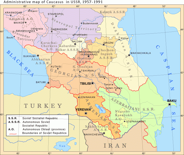
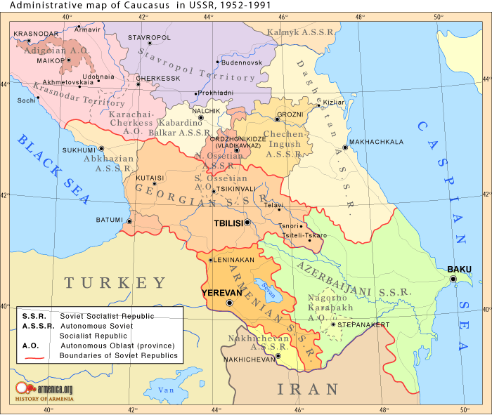
English: Administrative map of Caucasus in USSR, 1952-1991 |
| তারিখ |
Uploaded to Armenica.org before ৭ ডিসেম্বর ২০০৬ (archived version)
|
| উৎস | Originally uploded from en.wikipedia; description page is/was here. |
| লেখক | www.armenica.org |
| অন্যান্য সংস্করণ | العربيَّة |
লাইসেন্স প্রদান
[সম্পাদনা]

|
এই নথি অনুলিপি, বিতরণ এবং/বা পরিবর্তন করার অনুমতি ফ্রি সফটওয়্যার ফাউন্ডেশন কর্তৃক প্রকাশিত গনু ফ্রি ডকুমেন্টেশন লাইসেন্স, সংস্করণ ১.২ বা তার পরবর্তী সংস্করণের আওতায় অনুমতিপ্রাপ্ত; যে কোনো রকম অনুচ্ছেদ পরিবর্তন, সম্মুখ-প্রচ্ছদের লেখা, পিছন-প্রচ্ছদের লেখা পরিবর্তন করা ছাড়াই। এই লাইসেন্সের একটি অনুলিপি গনু ফ্রি ডকুমেন্টেশন লাইসেন্স শিরোনামের অনুচ্ছেদে অন্তর্ভুক্ত করা আছে। |
This permission only applies to images existing on http://armenica.org/ as of 1 January 2007. Any later images do not fall under this permission!
মূল আপলোড লগ
[সম্পাদনা]
(All user names refer to en.wikipedia)
- 2007-01-03 03:06 Artaxiad 700×590×6 (60613 bytes) Administrative map of [[Caucasus]] in USSR, 1952-1991 Source: Armenica.org [[Category:Armenica images]]
ফাইলের ইতিহাস
যেকোনো তারিখ/সময়ে ক্লিক করে দেখুন ফাইলটি তখন কী অবস্থায় ছিল।
| তারিখ/সময় | সংক্ষেপচিত্র | মাত্রা | ব্যবহারকারী | মন্তব্য | |
|---|---|---|---|---|---|
| বর্তমান | ১৬:৩০, ১০ মে ২০১২ | | ৭০০ × ৫৯০ (৮১ কিলোবাইট) | M0tty (আলোচনা | অবদান) | Licence autorising modification → remove watermark |
| ২০:০৩, ৫ মে ২০১২ |  | ৭০০ × ৫৯১ (৭৮ কিলোবাইট) | Geagea (আলোচনা | অবদান) | Original map according to the OTRS permission. Not to be reverted. | |
| ০৪:৪৯, ২৭ মার্চ ২০১১ |  | ৭০০ × ৫৯০ (৮১ কিলোবাইট) | Hellerick (আলোচনা | অবদান) | The earlier changes were correct. | |
| ১৯:১২, ১৬ জানুয়ারি ২০১১ |  | ৭০০ × ৫৯০ (৫৯ কিলোবাইট) | Geagea (আলোচনা | অবদান) | Reverted to version as of 10:16, 24 February 2007. To the uploader's last version | |
| ১৮:৩৮, ১৬ জানুয়ারি ২০১১ |  | ৭০০ × ৫৯০ (৮১ কিলোবাইট) | Nicolay Sidorov (আলোচনা | অবদান) | Adygea to Krasnodar, Karachay-Cherkess to Stavropol. | |
| ১৮:৩১, ১৬ জানুয়ারি ২০১১ |  | ৭০০ × ৫৯০ (৮০ কিলোবাইট) | Nicolay Sidorov (আলোচনা | অবদান) | The Chechen-Ingush republic was restored on January 9, 1957 | |
| ১০:১৬, ২৪ ফেব্রুয়ারি ২০০৭ |  | ৭০০ × ৫৯০ (৫৯ কিলোবাইট) | Hardscarf (আলোচনা | অবদান) | {{Information |Description=Administrative map of en:Caucasus in USSR, 1952-1991 |Source=Armenica.org {{ConfirmationImageOTRS|source=http://armenica.org/|otrs=2007010210006387}} Originally from [http://en.wikipedia.org en.wikipedia]; description page |
আপনি এই ফাইলটি প্রতিস্থাপন করতে পারবেন না।
ফাইলের ব্যবহার
নিম্নলিখিত 13টি পাতা এই ফাইল ব্যবহার করে:
ফাইলের বৈশ্বিক ব্যবহার
নিচের অন্যান্য উইকিগুলো এই ফাইলটি ব্যবহার করে:
- ar.wikipedia.org-এ ব্যবহার
- azb.wikipedia.org-এ ব্যবহার
- az.wikipedia.org-এ ব্যবহার
- ca.wikipedia.org-এ ব্যবহার
- el.wikipedia.org-এ ব্যবহার
- en.wikipedia.org-এ ব্যবহার
- et.wikipedia.org-এ ব্যবহার
- fi.wikipedia.org-এ ব্যবহার
- fo.wikipedia.org-এ ব্যবহার
- he.wikipedia.org-এ ব্যবহার
- hi.wikipedia.org-এ ব্যবহার
- hr.wikipedia.org-এ ব্যবহার
- id.wikipedia.org-এ ব্যবহার
- is.wikipedia.org-এ ব্যবহার
- ja.wikipedia.org-এ ব্যবহার
- jv.wikipedia.org-এ ব্যবহার
- ko.wikipedia.org-এ ব্যবহার
- nn.wikipedia.org-এ ব্যবহার
- no.wikipedia.org-এ ব্যবহার
- pl.wiktionary.org-এ ব্যবহার
- ro.wikipedia.org-এ ব্যবহার
- ru.wikipedia.org-এ ব্যবহার
- simple.wikipedia.org-এ ব্যবহার
এই ফাইলের অন্যান্য বৈশ্বিক ব্যবহার দেখুন।
বিষয়শ্রেণীসমূহ:
- Maps of the history of the Caucasus under Soviet rule
- 20th-century maps of the Caucasus
- Maps of the history of the south Caucasus region
- Maps of the history of Naxçıvan
- Maps of the history of Ajaria
- Maps of the history of Abkhazia
- Maps of the history of South Ossetia
- Maps of the history of Adygea
- Maps of the history of Karachay-Cherkessia
- Maps of the history of Kabardino-Balkaria
- Maps of the history of North Ossetia – Alania
- Maps of the history of Ingushetia
- Maps of the history of Chechnya
- Maps of the history of Dagestan
- Maps of the history of Kalmykia
- Maps of the Armenian Soviet Socialist Republic
- Maps of the Azerbaijan Soviet Socialist Republic
- Maps of the Georgian Soviet Socialist Republic
- Maps of the Russian Soviet Federative Socialist Republic
- Maps of the Transcaucasian Socialist Federative Soviet Republic
- English-language maps showing history