File:Central African Republic - Location Map (2013) - CAF - UNOCHA.svg

Fichier d’origine (Fichier SVG, nominalement de 253 × 253 pixels, taille : 417 kio)
Légendes
Légendes
Description
[modifier]_-_CAF_-_UNOCHA.svg&action=edit§ion=1)
| Description |
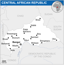
English: Locator map of Central African Republic. |
| Date | |
| Source |
English: Central African Republic Locator Map (ReliefWeb), ESRI, UNCS |
| Auteur | |
| SVG information |
Conditions d’utilisation
[modifier]_-_CAF_-_UNOCHA.svg&action=edit§ion=2)
- Vous êtes libre :
- de partager – de copier, distribuer et transmettre cette œuvre
- d’adapter – de modifier cette œuvre
- Sous les conditions suivantes :
- paternité – Vous devez donner les informations appropriées concernant l'auteur, fournir un lien vers la licence et indiquer si des modifications ont été faites. Vous pouvez faire cela par tout moyen raisonnable, mais en aucune façon suggérant que l’auteur vous soutient ou approuve l’utilisation que vous en faites.
 This map is part of a collection of 216 free country maps, created by the UN Office for the Coordination of Humanitarian Affairs (OCHA), to be used in print, web or broadcast products.
The ReliefWeb Location Maps released here are maps that highlight a country, its capital, major populated places and the surrounding regions. Attribution Requirements
Using the map without modifications: ensure that the sources and the disclaimer are below the map. Credit as follows: "Credit: OCHA". For use with alteration: remove the OCHA logo and disclaimer following any modification to the map, but keep the data sources as mentioned below the map. Credit the modified map as follows: "Based on OCHA map". You are responsible for the content of your map. We are keen to receive your feedback and hear how you used OCHA's maps. We would be grateful if you would notify us by e-mail and share your work with us. UN Disclaimer
The designations employed and the presentation of material of this map do not imply the expression of any opinion whatsoever on the part of the Secretariat of the United Nations concerning the legal status of any country, territory, city or area or of its authorities or concerning the delimitation of its frontiers or boundaries. |
Historique du fichier
Cliquer sur une date et heure pour voir le fichier tel qu'il était à ce moment-là.
| Date et heure | Vignette | Dimensions | Utilisateur | Commentaire | |
|---|---|---|---|---|---|
| actuel | 18 novembre 2014 à 03:06 | | 253 × 253 (417 kio) | Pharos (d | contributions) | try without logo for now |
| 15 juillet 2014 à 20:08 |  | 253 × 253 (358 kio) | Palmerop (d | contributions) | User created page with UploadWizard |
Vous ne pouvez pas remplacer ce fichier.
Utilisations locales du fichier
La page suivante utilise ce fichier :
- File:Locator map of the Central African Republic.svg (redirection de fichier)
Utilisations du fichier sur d’autres wikis
Les autres wikis suivants utilisent ce fichier :
- Utilisation sur azb.wikipedia.org
- Utilisation sur bh.wikipedia.org
- Utilisation sur bn.wikipedia.org
- Utilisation sur ca.wikipedia.org
- Utilisation sur fa.wikipedia.org
- Utilisation sur fr.wikipedia.org
- Utilisation sur gu.wikipedia.org
- Utilisation sur id.wikipedia.org
- Utilisation sur lb.wikipedia.org
- Utilisation sur lfn.wikipedia.org
- Utilisation sur mzn.wikipedia.org
- Utilisation sur pl.wikipedia.org
- Utilisation sur sco.wikipedia.org
- Utilisation sur sd.wikipedia.org
- Utilisation sur www.wikidata.org
_-_CAF_-_UNOCHA.svg&oldid=852527857)