File:Central Asia - political map - 2000-hi.svg
Jump to navigation
Jump to search

Size of this PNG preview of this SVG file: 755 × 599 pixels. Other resolutions: 302 × 240 pixels | 605 × 480 pixels | 967 × 768 pixels | 1,280 × 1,016 pixels | 2,560 × 2,033 pixels | 995 × 790 pixels.
Original file (SVG file, nominally 995 × 790 pixels, file size: 162 KB)
Captions
Captions
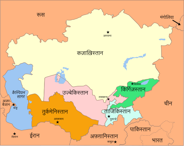
Central Asia - Political Map - 2000
Summary
[edit]| Description |
English: Political Map of the Caucasus and Central Asia, circa 2000
हिन्दी: कॉकस और मध्य एशिया का राजनीतिक मानचित्र, सन 2000 के आस-पास |
| Date | |
| Source | from Caucasus_central_asia_political_map_2000.jpg by Themightyquill |
| Author | translated by user:nilesh shukla |
| Other versions |
[]
|


Licensing
[edit]
This file is licensed under the Creative Commons Attribution-Share Alike 3.0 Unported license.
- You are free:
- to share – to copy, distribute and transmit the work
- to remix – to adapt the work
- Under the following conditions:
- attribution – You must give appropriate credit, provide a link to the license, and indicate if changes were made. You may do so in any reasonable manner, but not in any way that suggests the licensor endorses you or your use.
- share alike – If you remix, transform, or build upon the material, you must distribute your contributions under the same or compatible license as the original.
File history
Click on a date/time to view the file as it appeared at that time.
| Date/Time | Thumbnail | Dimensions | User | Comment | |
|---|---|---|---|---|---|
| current | 10:59, 5 March 2019 | | 995 × 790 (162 KB) | Nilesh shukla (talk | contribs) | User created page with UploadWizard |
You cannot overwrite this file.
File usage on Commons
The following 8 pages use this file:
- File:Central Asia - political map - 2000-gu.svg
- File:Central Asia - political map - 2000-hi.svg
- File:Central Asia - political map - 2000-pa.svg
- File:Central Asia - political map - 2000-te.svg
- File:Central Asia - political map - 2000.svg
- File:Central Asia - political map - 2000 as.svg
- File:Central Asia - political map - 2000 ur.svg
- Template:Other versions/Central Asia - political map - 2000