File:Central balkans 1373 1395.png
Aller à la navigation
Aller à la recherche

Taille de cet aperçu : 591 × 599 pixels. Autres résolutions : 237 × 240 pixels | 473 × 480 pixels | 757 × 768 pixels | 1 010 × 1 024 pixels | 2 019 × 2 048 pixels | 2 600 × 2 637 pixels.
Fichier d’origine (2 600 × 2 637 pixels, taille du fichier : 249 kio, type MIME : image/png)
Légendes
Légendes
Ajoutez en une ligne la description de ce que représente ce fichier
| Description |
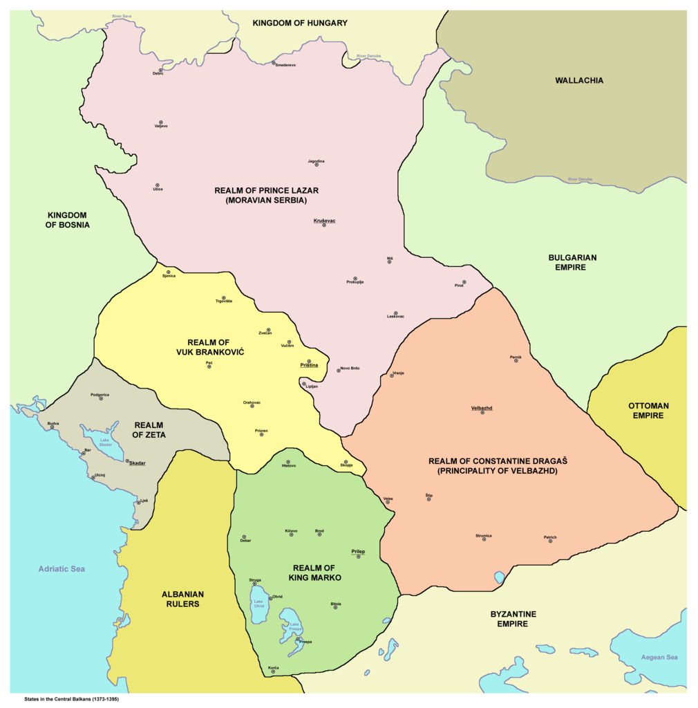
English: States in the Central Balkans that emerged after dissolution of Serbian Empire in the 14th century (1373-1395):
Српски / srpski: Države na centralnom Balkanu koje su nastale posle raspada Srpskog carstva u 14. veku (1373-1395):
Srpskohrvatski / српскохрватски: Države na centralnom Balkanu nastale raspadom Dušanovog carstva u 14. veku (1373-1395):
|
||
| Date | |||
| Source | English Wikipedia | ||
| Auteur | PANONIAN | ||
| Autorisation (Réutilisation de ce fichier) |
|
||
| Autres versions |
     |
.png)
References[modifier]
- Istorijski atlas, Geokarta, Beograd, 1999.
- Denis Šehić - Demir Šehić, Istorijski atlas Sveta, Beograd, 2007.
- The Times History of Europe, Times Books, London, 2002.
- Vladimir Ćorović, Ilustrovana istorija Srba, knjiga druga, Beograd, 2005.
- Srpski narod u drugoj polovini XIV i u prvoj polovini XV veka, Zbornik radova, Beograd, 1989.
- Petrit Imami, Srbi i Albanci kroz vekove, Beograd, 2000.
- Miloš Blagojević, Srbija Nemanjića i Hilandar, Beograd - Novi Sad, 1998.
- http://i6.photobucket.com/albums/y226/mindaugas/Srpstvo/srpskezemlje1373do1395.jpg (Note: image from Photobucket used only as a secondary reference)
- http://www.rgz.gov.rs/kart-proizvodi/artikli%5C055610.jpg[lien mort]
Historique du fichier
Cliquer sur une date et heure pour voir le fichier tel qu'il était à ce moment-là.
| Date et heure | Vignette | Dimensions | Utilisateur | Commentaire | |
|---|---|---|---|---|---|
| actuel | 10 décembre 2011 à 19:00 | | 2 600 × 2 637 (249 kio) | PANONIAN (d | contributions) | aesthetics |
| 12 janvier 2011 à 10:02 |  | 2 581 × 2 643 (248 kio) | PANONIAN (d | contributions) | Reverted to version as of 13:03, 10 March 2010 - it did according to my history atlas. borders in this map are same as in that atlas. if your sources are claiming something else then please draw and upload another map based on such sources | |
| 11 janvier 2011 à 21:41 |  | 2 581 × 2 643 (312 kio) | Olahus (d | contributions) | Serbia didn't border to Wallachia. | |
| 10 mars 2010 à 13:03 |  | 2 581 × 2 643 (248 kio) | PANONIAN (d | contributions) | Reverted to version as of 22:22, 8 March 2010 | |
| 8 mars 2010 à 22:56 |  | 1 500 × 1 500 (140 kio) | VízPart (d | contributions) | much better version. please upload your own as separate | |
| 8 mars 2010 à 22:22 |  | 2 581 × 2 643 (248 kio) | PANONIAN (d | contributions) | Reverted to version as of 12:11, 8 March 2010 - please do not do that | |
| 8 mars 2010 à 21:40 |  | 1 500 × 1 500 (140 kio) | VízPart (d | contributions) | better version | |
| 8 mars 2010 à 12:11 |  | 2 581 × 2 643 (248 kio) | PANONIAN (d | contributions) | Reverted to version as of 23:35, 13 January 2010 - rv - please upload your version as separate file, I do not agree with that colour change | |
| 8 mars 2010 à 02:18 |  | 1 500 × 1 500 (140 kio) | Ajdebre (d | contributions) | improved | |
| 13 janvier 2010 à 23:35 |  | 2 581 × 2 643 (248 kio) | PANONIAN (d | contributions) | improved version |
Vous ne pouvez pas remplacer ce fichier.
Utilisations locales du fichier
Les 10 pages suivantes utilisent ce fichier :
Utilisations du fichier sur d’autres wikis
Les autres wikis suivants utilisent ce fichier :
- Utilisation sur ar.wikipedia.org
- Utilisation sur arz.wikipedia.org
- Utilisation sur azb.wikipedia.org
- Utilisation sur az.wikipedia.org
- Utilisation sur ba.wikipedia.org
- Utilisation sur bg.wikipedia.org
- Utilisation sur bs.wikipedia.org
- Utilisation sur ca.wikipedia.org
- Utilisation sur cs.wikipedia.org
- Utilisation sur de.wikipedia.org
- Utilisation sur el.wikipedia.org
- Utilisation sur en.wikipedia.org
- Utilisation sur et.wikipedia.org
- Utilisation sur fr.wikipedia.org
- Utilisation sur gl.wikipedia.org
- Utilisation sur hr.wikipedia.org
- Utilisation sur id.wikipedia.org
- Utilisation sur it.wikipedia.org
Voir davantage sur l’utilisation globale de ce fichier.
Catégories :
- Maps of 14th-century Serbia
- Maps of the Principality of Serbia (late medieval)
- Maps of the history of North Macedonia in the Middle Ages
- Maps of 14th-century Bulgaria
- Maps of the history of Romania in the Middle Ages
- Maps of the Principality of Zeta in the 14th century
- Maps of the history of Kosovo in the Middle Ages
- Maps of the history of the medieval Balkans
- Realm of Vuk Branković
- Realm of King Marko
- Domain of the Dejanović noble family