File:Central balkans 1373 1395.png
ナビゲーションに移動
検索に移動

このプレビューのサイズ: 591 × 599 ピクセル。 その他の解像度: 237 × 240 ピクセル | 473 × 480 ピクセル | 757 × 768 ピクセル | 1,010 × 1,024 ピクセル | 2,019 × 2,048 ピクセル | 2,600 × 2,637 ピクセル。
元のファイル (2,600 × 2,637 ピクセル、ファイルサイズ: 249キロバイト、MIME タイプ: image/png)
キャプション
キャプション
このファイルの内容を1行で記述してください
| 解説 |
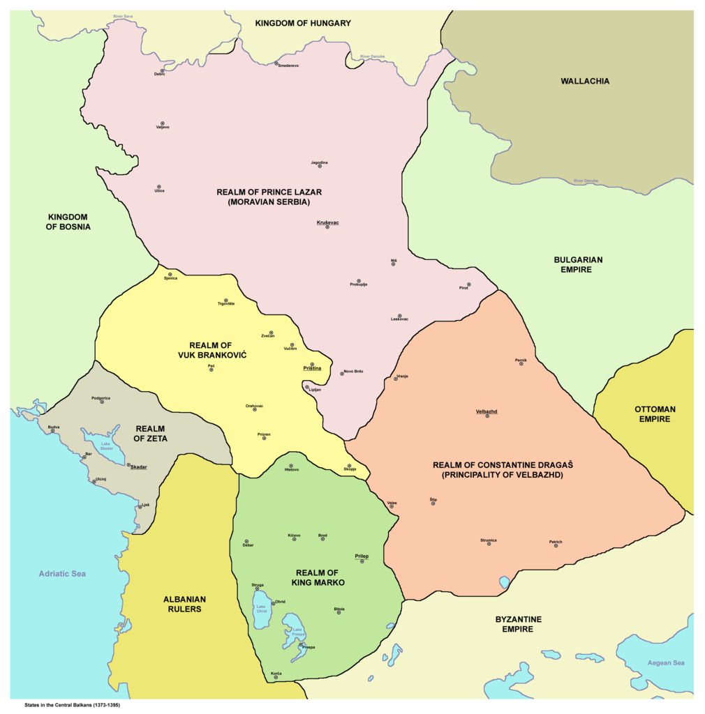
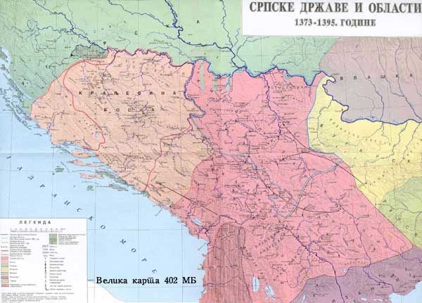
English: States in the Central Balkans that emerged after dissolution of Serbian Empire in the 14th century (1373-1395):
Српски / srpski: Države na centralnom Balkanu koje su nastale posle raspada Srpskog carstva u 14. veku (1373-1395):
Srpskohrvatski / српскохрватски: Države na centralnom Balkanu nastale raspadom Dušanovog carstva u 14. veku (1373-1395):
|
||
| 日付 | |||
| 原典 | English Wikipedia | ||
| 作者 | PANONIAN | ||
| 許可 (ファイルの再利用) |
|
||
| その他のバージョン |
     |
.png)
References[編集]
- Istorijski atlas, Geokarta, Beograd, 1999.
- Denis Šehić - Demir Šehić, Istorijski atlas Sveta, Beograd, 2007.
- The Times History of Europe, Times Books, London, 2002.
- Vladimir Ćorović, Ilustrovana istorija Srba, knjiga druga, Beograd, 2005.
- Srpski narod u drugoj polovini XIV i u prvoj polovini XV veka, Zbornik radova, Beograd, 1989.
- Petrit Imami, Srbi i Albanci kroz vekove, Beograd, 2000.
- Miloš Blagojević, Srbija Nemanjića i Hilandar, Beograd - Novi Sad, 1998.
- http://i6.photobucket.com/albums/y226/mindaugas/Srpstvo/srpskezemlje1373do1395.jpg (Note: image from Photobucket used only as a secondary reference)
- http://www.rgz.gov.rs/kart-proizvodi/artikli%5C055610.jpg[dead link]
ファイルの履歴
過去の版のファイルを表示するには、その版の日時をクリックしてください。
| 日付と時刻 | サムネイル | 寸法 | 利用者 | コメント | |
|---|---|---|---|---|---|
| 現在の版 | 2011年12月10日 (土) 19:00 | | 2,600 × 2,637 (249キロバイト) | PANONIAN (トーク | 投稿記録) | aesthetics |
| 2011年1月12日 (水) 10:02 |  | 2,581 × 2,643 (248キロバイト) | PANONIAN (トーク | 投稿記録) | Reverted to version as of 13:03, 10 March 2010 - it did according to my history atlas. borders in this map are same as in that atlas. if your sources are claiming something else then please draw and upload another map based on such sources | |
| 2011年1月11日 (火) 21:41 |  | 2,581 × 2,643 (312キロバイト) | Olahus (トーク | 投稿記録) | Serbia didn't border to Wallachia. | |
| 2010年3月10日 (水) 13:03 |  | 2,581 × 2,643 (248キロバイト) | PANONIAN (トーク | 投稿記録) | Reverted to version as of 22:22, 8 March 2010 | |
| 2010年3月8日 (月) 22:56 |  | 1,500 × 1,500 (140キロバイト) | VízPart (トーク | 投稿記録) | much better version. please upload your own as separate | |
| 2010年3月8日 (月) 22:22 |  | 2,581 × 2,643 (248キロバイト) | PANONIAN (トーク | 投稿記録) | Reverted to version as of 12:11, 8 March 2010 - please do not do that | |
| 2010年3月8日 (月) 21:40 |  | 1,500 × 1,500 (140キロバイト) | VízPart (トーク | 投稿記録) | better version | |
| 2010年3月8日 (月) 12:11 |  | 2,581 × 2,643 (248キロバイト) | PANONIAN (トーク | 投稿記録) | Reverted to version as of 23:35, 13 January 2010 - rv - please upload your version as separate file, I do not agree with that colour change | |
| 2010年3月8日 (月) 02:18 |  | 1,500 × 1,500 (140キロバイト) | Ajdebre (トーク | 投稿記録) | improved | |
| 2010年1月13日 (水) 23:35 |  | 2,581 × 2,643 (248キロバイト) | PANONIAN (トーク | 投稿記録) | improved version |
このファイルは上書きできません。
ファイルの使用状況
以下の 10 ページがこのファイルを使用しています:
グローバルなファイル使用状況
以下に挙げる他のウィキがこの画像を使っています:
- ar.wikipedia.org での使用状況
- arz.wikipedia.org での使用状況
- azb.wikipedia.org での使用状況
- az.wikipedia.org での使用状況
- ba.wikipedia.org での使用状況
- bg.wikipedia.org での使用状況
- bs.wikipedia.org での使用状況
- ca.wikipedia.org での使用状況
- cs.wikipedia.org での使用状況
- de.wikipedia.org での使用状況
- el.wikipedia.org での使用状況
- en.wikipedia.org での使用状況
- et.wikipedia.org での使用状況
- fr.wikipedia.org での使用状況
- gl.wikipedia.org での使用状況
- hr.wikipedia.org での使用状況
- id.wikipedia.org での使用状況
- it.wikipedia.org での使用状況
このファイルのグローバル使用状況を表示する。
カテゴリ:
- Maps of 14th-century Serbia
- Maps of the Principality of Serbia (late medieval)
- Maps of the history of North Macedonia in the Middle Ages
- Maps of 14th-century Bulgaria
- Maps of the history of Romania in the Middle Ages
- Maps of the Principality of Zeta in the 14th century
- Maps of the history of Kosovo in the Middle Ages
- Maps of the history of the medieval Balkans
- Realm of Vuk Branković
- Realm of King Marko
- Domain of the Dejanović noble family