File:Central europe 1572.png
Zur Navigation springen
Zur Suche springen
Größe dieser Vorschau: 628 × 599 Pixel. Weitere Auflösungen: 251 × 240 Pixel | 503 × 480 Pixel | 922 × 880 Pixel.
Originaldatei (922 × 880 Pixel, Dateigröße: 120 KB, MIME-Typ: image/png)
Bildtexte
Kurzbeschreibungen
Ergänze eine einzeilige Erklärung, was diese Datei darstellt.
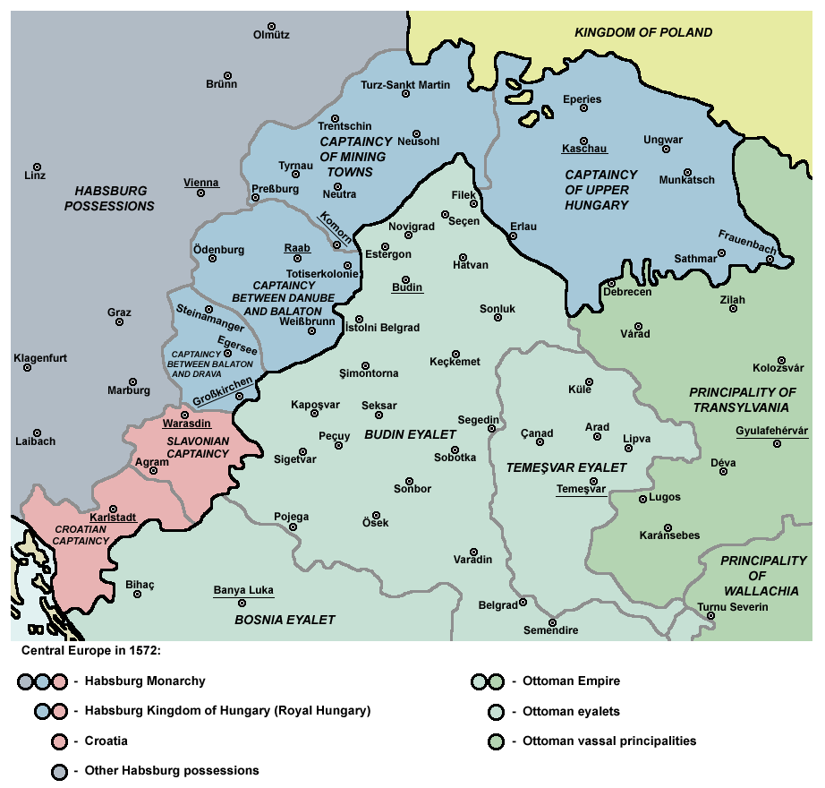
Map of Central Europe in 1572
Beschreibung[Bearbeiten]
| Beschreibung |
English: Captaincies of the Kingdom of Hungary in 1572: Habsburg Hungary (Royal Hungary), Habsburg Slavonia, Habsburg Croatia, Ottoman Budin Eyalet, Ottoman Temeşvar Eyalet. |
| Datum | |
| Quelle | Eigenes Werk |
| Urheber | PANONIAN |
| Andere Versionen |
|

Lizenz[Bearbeiten]
Ich, der Urheber dieses Werkes, veröffentliche es unter der folgenden Lizenz:
| Diese Datei wird unter der Creative-Commons-Lizenz „CC0 1.0 Verzicht auf das Copyright“ zur Verfügung gestellt. | |
| Die Person, die das Werk mit diesem Dokument verbunden hat, übergibt dieses weltweit der Gemeinfreiheit, indem sie alle Urheberrechte und damit verbundenen weiteren Rechte – im Rahmen der jeweils geltenden gesetzlichen Bestimmungen – aufgibt. Das Werk kann – selbst für kommerzielle Zwecke – kopiert, modifiziert und weiterverteilt werden, ohne hierfür um Erlaubnis bitten zu müssen.
|
References[Bearbeiten]
- http://www.sulinet.hu/eletmod/hogyantovabb/tovabbtanulas/elokeszito/tortenelem/6het/map.jpg
- http://honismeret.uw.hu/pictures/history/oszman_torok_birodalom_big.jpg Archivkopie in der Wayback Machine
- http://www.kepido.oszk.hu/attachments/images/nagy/pe94122.jpg
- http://mek.niif.hu/01800/01885/html/cd5m/kepek/nyelvtortenet/ny251pe94122.jpg
- http://mek.oszk.hu/01800/01885/html/cd5m/kepek/c4341pe94122.jpg
- http://mek.oszk.hu/01800/01885/html/cd5m/kepek/tortenelem/to321pe94123b.jpg
- http://hu.wikipedia.org/wiki/Fájl:Torokvilag.jpg[toter Link]
- http://www.sulinet.hu/oroksegtar/data/telepulesek_ertekei/Erd/pages/images/221.jpg
- http://xxlworld.xx.ohost.de/povijest/slike/mape/1606.jpg
- http://www.hic.hr/books/pavlicev/images/s05.gif Archivkopie in der Wayback Machine
- The Times History of Europe, Times Books, London, 2002.
- Peter Rokai - Zoltan Đere - Tibor Pal - Aleksandar Kasaš, Istorija Mađara, Beograd, 2002.
- Dr Dušan J. Popović, Srbi u Vojvodini, knjiga 1, Novi Sad, 1990.
- Dr D. J. Popović, Vojvodina u tursko doba, Zbornik "Vojvodina", knjiga I, Fototipsko izdanje, PROMETEJ, Novi Sad, 2008.
- Halil Inaldžik, Osmansko carstvo, Beograd, 2003.
Dateiversionen
Klicke auf einen Zeitpunkt, um diese Version zu laden.
| Version vom | Vorschaubild | Maße | Benutzer | Kommentar | |
|---|---|---|---|---|---|
| aktuell | 10:36, 5. Sep. 2011 | | 922 × 880 (120 KB) | PANONIAN (Diskussion | Beiträge) | {{Information |Description ={{en|1=Map of Central Europe in 1572: Habsburg Kingdom of Hungary (Royal Hungary), Habsburg Croatia, Ottoman Budin Eyalet, Ottoman Temeşvar Eyalet. }} |Source ={{own}} |Author =PANONIAN |Da |
Du kannst diese Datei nicht überschreiben.
Dateiverwendung
Die folgenden 5 Seiten verwenden diese Datei:
Globale Dateiverwendung
Die nachfolgenden anderen Wikis verwenden diese Datei:
- Verwendung auf ar.wikipedia.org
- Verwendung auf be.wikipedia.org
- Verwendung auf bg.wikipedia.org
- Verwendung auf bs.wikipedia.org
- Verwendung auf cs.wikipedia.org
- Verwendung auf de.wikipedia.org
- Verwendung auf el.wikipedia.org
- Verwendung auf en.wikipedia.org
- Burgenland
- List of administrative divisions of the Kingdom of Hungary
- Kingdom of Hungary (1526–1867)
- Upper Hungary
- Talk:Upper Hungary
- Ottoman Hungary
- Budin Eyalet
- Captaincies of the Kingdom of Hungary
- Eparchy of Marča
- Transformation of the Ottoman Empire
- User:Falcaorib
- Palanka (fortification)
- Wikipedia:Graphics Lab/Map workshop/Archive/Mar 2023
- Verwendung auf eo.wikipedia.org
- Verwendung auf es.wikipedia.org
- Verwendung auf et.wikipedia.org
- Verwendung auf fa.wikipedia.org
- Verwendung auf fr.wikipedia.org
- Verwendung auf he.wikipedia.org
Weitere globale Verwendungen dieser Datei anschauen.
Kategorien:
- Maps of the history of Central Europe
- Maps of the Habsburg Monarchy
- Maps of eyalets of the Ottoman Empire
- Maps of vassal states of the Ottoman Empire
- Maps of the history of the Ottoman Empire in the 1570s
- Maps of the history of Hungary (1526–1700)
- Maps of the history of Slovakia
- Maps of the history of Croatia (1526–1918)
- Maps of the history of Slavonia
- Maps of the Ottoman period in the history of Serbia
- Maps of the history of Vojvodina
- Maps of the history of Banat
- Maps of the history of Early Modern Romania
- Maps of the history of Transylvania
- Kingdom of Hungary (1526–1867)
- Budin Province, Ottoman Empire
- Maps of Temeşvar Province, Ottoman Empire
- Principality of Transylvania
- Slavonian Military Frontier