File:Central europe 1572.png
跳至導覽
跳至搜尋
預覽大小:628 × 599 像素。 其他解析度:251 × 240 像素 | 503 × 480 像素 | 922 × 880 像素。
原始檔案 (922 × 880 像素,檔案大小:120 KB,MIME 類型:image/png)
說明
說明
添加單行說明來描述出檔案所代表的內容
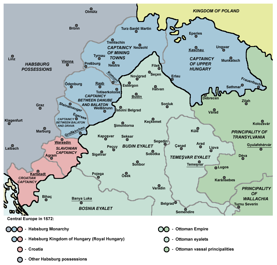
Map of Central Europe in 1572
摘要
[編輯]| 描述 |
English: Captaincies of the Kingdom of Hungary in 1572: Habsburg Hungary (Royal Hungary), Habsburg Slavonia, Habsburg Croatia, Ottoman Budin Eyalet, Ottoman Temeşvar Eyalet. |
| 日期 | |
| 來源 | 自己的作品 |
| 作者 | PANONIAN |
| 其他版本 |
|

授權條款
[編輯]
我,本作品的著作權持有者,決定用以下授權條款發佈本作品:
| 此檔案在創用CC CC0 1.0 通用公有領域貢獻宣告之下分發。 | |
| 在此宣告之下分發本作品者,已依據各國著作權法,在全世界放棄其對本作品所擁有的著作權及所有相關相似的法律權利,從而將本作品貢獻至公有領域。您可以複製、修改、分發和演示該作品,用於任何商業用途,所有這些都不需要請求授權。
|
References
[編輯]
- http://www.sulinet.hu/eletmod/hogyantovabb/tovabbtanulas/elokeszito/tortenelem/6het/map.jpg
- http://honismeret.uw.hu/pictures/history/oszman_torok_birodalom_big.jpg archive copy at the Wayback Machine
- http://www.kepido.oszk.hu/attachments/images/nagy/pe94122.jpg
- http://mek.niif.hu/01800/01885/html/cd5m/kepek/nyelvtortenet/ny251pe94122.jpg
- http://mek.oszk.hu/01800/01885/html/cd5m/kepek/c4341pe94122.jpg
- http://mek.oszk.hu/01800/01885/html/cd5m/kepek/tortenelem/to321pe94123b.jpg
- http://hu.wikipedia.org/wiki/Fájl:Torokvilag.jpg[失效連結]
- http://www.sulinet.hu/oroksegtar/data/telepulesek_ertekei/Erd/pages/images/221.jpg
- http://xxlworld.xx.ohost.de/povijest/slike/mape/1606.jpg
- http://www.hic.hr/books/pavlicev/images/s05.gif archive copy at the Wayback Machine
- The Times History of Europe, Times Books, London, 2002.
- Peter Rokai - Zoltan Đere - Tibor Pal - Aleksandar Kasaš, Istorija Mađara, Beograd, 2002.
- Dr Dušan J. Popović, Srbi u Vojvodini, knjiga 1, Novi Sad, 1990.
- Dr D. J. Popović, Vojvodina u tursko doba, Zbornik "Vojvodina", knjiga I, Fototipsko izdanje, PROMETEJ, Novi Sad, 2008.
- Halil Inaldžik, Osmansko carstvo, Beograd, 2003.
檔案歷史
點選日期/時間以檢視該時間的檔案版本。
| 日期/時間 | 縮圖 | 尺寸 | 用戶 | 備註 | |
|---|---|---|---|---|---|
| 目前 | 2011年9月5日 (一) 10:36 | | 922 × 880(120 KB) | PANONIAN(對話 | 貢獻) | {{Information |Description ={{en|1=Map of Central Europe in 1572: Habsburg Kingdom of Hungary (Royal Hungary), Habsburg Croatia, Ottoman Budin Eyalet, Ottoman Temeşvar Eyalet. }} |Source ={{own}} |Author =PANONIAN |Da |
無法覆蓋此檔案。
檔案用途
下列5個頁面有用到此檔案:
全域檔案使用狀況
以下其他 wiki 使用了這個檔案:
- ar.wikipedia.org 的使用狀況
- be.wikipedia.org 的使用狀況
- bg.wikipedia.org 的使用狀況
- bs.wikipedia.org 的使用狀況
- cs.wikipedia.org 的使用狀況
- de.wikipedia.org 的使用狀況
- el.wikipedia.org 的使用狀況
- en.wikipedia.org 的使用狀況
- Burgenland
- List of administrative divisions of the Kingdom of Hungary
- Kingdom of Hungary (1526–1867)
- Upper Hungary
- Talk:Upper Hungary
- Ottoman Hungary
- Budin Eyalet
- Captaincies of the Kingdom of Hungary
- Eparchy of Marča
- Transformation of the Ottoman Empire
- Palanka (fortification)
- Wikipedia:Graphics Lab/Map workshop/Archive/Mar 2023
- User:Falcaorib/Modern Empires (1500-1800 AD)
- User:Falcaorib/Austria-Hungary
- eo.wikipedia.org 的使用狀況
- es.wikipedia.org 的使用狀況
- et.wikipedia.org 的使用狀況
- fa.wikipedia.org 的使用狀況
- fr.wikipedia.org 的使用狀況
- he.wikipedia.org 的使用狀況
檢視此檔案的更多全域使用狀況。
分類:
- Maps of the history of Central Europe
- Maps of the Habsburg Monarchy
- Maps of eyalets of the Ottoman Empire
- Maps of vassal states of the Ottoman Empire
- Maps of the history of the Ottoman Empire in the 1570s
- Maps of the history of Hungary (1526–1700)
- Maps of the history of Slovakia
- Maps of the history of Croatia (1526–1918)
- Maps of the history of Slavonia
- Maps of the Ottoman period in the history of Serbia
- Maps of the history of Vojvodina
- Maps of the history of Banat
- Maps of the history of Early Modern Romania
- Maps of the history of Transylvania
- Kingdom of Hungary (1526–1867)
- Budin Province, Ottoman Empire
- Maps of Temeşvar Province, Ottoman Empire
- Principality of Transylvania
- Slavonian Military Frontier