File:Central europe 1683.png
跳至導覽
跳至搜尋

預覽大小:790 × 599 像素。 其他解析度:317 × 240 像素 | 633 × 480 像素 | 1,013 × 768 像素 | 1,280 × 971 像素。
原始檔案 (1,280 × 971 像素,檔案大小:406 KB,MIME 類型:image/png)
說明
說明
添加單行說明來描述出檔案所代表的內容
摘要
[編輯]
| 描述 |
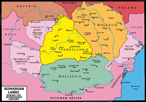
English: Central Europe during the short-term existence of Imre Thököly's Principality of Upper Hungary. - Habsburg and Ottoman territories, including Habsburg Kingdom of Hungary (Royal Hungary) and Habsburg Croatia, Ottoman vassal states (Wallachia, Moldavia, Transylvania, Principality of Upper Hungary (existed between 1682-1685), Montenegro, Ragusa) and Ottoman eyalets. The Ottoman expansion was asked by prince Imre Thököly in Upper Hungary (centered in present-day Slovakia) against the Habsburgs. The Ottoman Rule in Upper Hungary lasted only for 3 years. |
| 日期 | |
| 來源 | 自己的作品 |
| 作者 | PANONIAN |
| 其他版本 |
Derivative works of this file:
|
授權條款
[編輯]
我,本作品的著作權持有者,決定用以下授權條款發佈本作品:
| 此檔案在創用CC CC0 1.0 通用公有領域貢獻宣告之下分發。 | |
| 在此宣告之下分發本作品者,已依據各國著作權法,在全世界放棄其對本作品所擁有的著作權及所有相關相似的法律權利,從而將本作品貢獻至公有領域。您可以複製、修改、分發和演示該作品,用於任何商業用途,所有這些都不需要請求授權。
|
References
[編輯]
- The Times History of Europe, Times Books, London, 2002.
- Peter Rokai - Zoltan Đere - Tibor Pal - Aleksandar Kasaš, Istorija Mađara, Beograd, 2002.
- Dr Dušan J. Popović, Srbi u Vojvodini, knjiga 1, Novi Sad, 1990.
- Dr D. J. Popović, Vojvodina u tursko doba, Zbornik "Vojvodina", knjiga I, Fototipsko izdanje, PROMETEJ, Novi Sad, 2008.
- Halil Inaldžik, Osmansko carstvo, Beograd, 2003.
- Petrit Imami, Srbi i Albanci kroz vekove, Beograd, 2000.
- File:Magyar- és Erdélyország 1629-ben (Pallas).jpg
- http://www.sulinet.hu/oroksegtar/data/telepulesek_ertekei/Erd/pages/images/221.jpg
- http://www.zum.de/whkmla/region/balkans/xsilistra.html
- http://www.euratlas.net/history/europe/1600/index.html
- http://www.freeweb.hu/csodaszarvas/galeria/galeria09/001/large_terkep12.jpg
- http://mek.niif.hu/01800/01885/html/cd5m/kepek/tortenelem/to212pe94185.jpg
- http://www.tortenelemklub.hu/galeries/6/Wesselényi%20legújabb.JPG[失效連結]
- http://farm4.static.flickr.com/3361/3657063110_1532418eb3.jpg
- http://www.camo.ch/Images/bpasaluk06.jpg archive copy at the Wayback Machine
- http://medlem.spray.se/zelenika/sandzak.jpg[失效連結]
- http://img375.imageshack.us/img375/7287/pasaluk2.png
- http://www.camo.ch/Images3/bhpasaluk.jpg archive copy at the Wayback Machine
- http://xxlworld.xx.ohost.de/povijest/slike/mape/1606.jpg
- http://www.hic.hr/books/pavlicev/images/s05.gif archive copy at the Wayback Machine
- http://api.wb21.net/images/a-torok-hodoltsag-kora-magyar-tortenelem/dr-blaskovics-jozsef,az-ujvari-ejalet-torok-adoosszeirasai.jpg archive copy at the Wayback Machine
.jpg)
檔案歷史
點選日期/時間以檢視該時間的檔案版本。
| 日期/時間 | 縮圖 | 尺寸 | 用戶 | 備註 | |
|---|---|---|---|---|---|
| 目前 | 2020年1月31日 (五) 12:48 | | 1,280 × 971(406 KB) | Claude Zygiel(對話 | 貢獻) | Belergad eyalet cited in: Artin Hindoğlu's "Kurzwörterbuch Türkisch-Deutsch / Dictionnaire abrégé Turc-Français", Wien 1838, p. 125. |
| 2018年4月8日 (日) 21:35 |  | 1,280 × 971(390 KB) | Filederchest(對話 | 貢獻) | info | |
| 2018年4月8日 (日) 19:06 |  | 1,280 × 971(378 KB) | Filederchest(對話 | 貢獻) | Principality of Upper Hungary | |
| 2017年1月28日 (六) 15:19 |  | 1,543 × 1,170(146 KB) | PANONIAN(對話 | 貢獻) | Reverted to version as of 20:47, 8 September 2011 (UTC) - this shows vassal principalities as separate states which they were not | |
| 2017年1月25日 (三) 20:52 |  | 1,543 × 1,170(135 KB) | Mélomène(對話 | 貢獻) | Contrast | |
| 2011年9月8日 (四) 20:47 |  | 1,543 × 1,170(146 KB) | PANONIAN(對話 | 貢獻) | corrected version | |
| 2011年9月5日 (一) 16:59 |  | 1,543 × 1,170(143 KB) | PANONIAN(對話 | 貢獻) | {{Information |Description ={{en|1=Central Europe in 1683.}} |Source ={{own}} |Author =PANONIAN |Date =2011 |Permission = |other_versions = }} |
無法覆蓋此檔案。
檔案用途
下列13個頁面有用到此檔案:
- Atlas of Bosnia and Herzegovina
- Atlas of Croatia
- Atlas of Hungary
- Atlas of Moldova
- Atlas of Romania
- Atlas of Slovakia
- Atlas of Transylvania
- Atlas of Vojvodina
- User:J budissin/Uploads/BiH/2017 January 21-31
- User:J budissin/Uploads/BiH/2018 April 1-10
- User:J budissin/Uploads/BiH/2020 January 21-31
- Commons:Graphic Lab/Map workshop/Archive/2014
- Category:Budin Province, Ottoman Empire
全域檔案使用狀況
以下其他 wiki 使用了這個檔案:
- an.wikipedia.org 的使用狀況
- ar.wikipedia.org 的使用狀況
- arz.wikipedia.org 的使用狀況
- azb.wikipedia.org 的使用狀況
- az.wikipedia.org 的使用狀況
- ba.wikipedia.org 的使用狀況
- be-tarask.wikipedia.org 的使用狀況
- be.wikipedia.org 的使用狀況
- bg.wikipedia.org 的使用狀況
- bn.wikipedia.org 的使用狀況
- bs.wikipedia.org 的使用狀況
- ca.wikipedia.org 的使用狀況
- cs.wikipedia.org 的使用狀況
- de.wikipedia.org 的使用狀況
- el.wikipedia.org 的使用狀況
- en.wikipedia.org 的使用狀況
檢視此檔案的更多全域使用狀況。
詮釋資料
分類:
- Maps of the history of Central Europe
- Maps of the Habsburg Monarchy
- Maps of eyalets of the Ottoman Empire
- Maps of vassal states of the Ottoman Empire
- Maps of the history of the Ottoman Empire in the 1680s
- Maps of the history of Hungary (1526–1700)
- Maps of the history of Slovakia
- Maps of the history of Croatia (1526–1918)
- Maps of the history of Bosnia and Herzegovina under Ottoman Empire
- Maps of the Ottoman period in the history of Serbia
- Maps of the history of Vojvodina
- Maps of the history of Banat
- Maps of the history of Early Modern Romania
- Maps of the history of Transylvania
- Maps of the history of Moldova
- Kingdom of Hungary (1526–1867)
- Principality of Upper Hungary
- Eyalet of Bosnia
- Budin Province, Ottoman Empire
- Kanije Province, Ottoman Empire
- Eğri Province, Ottoman Empire
- Maps of Temeşvar Province, Ottoman Empire
- Varat Province, Ottoman Empire
- Uyvar Province, Ottoman Empire
- Principality of Transylvania
- Maps of Wallachia
- Maps of the Principality of Moldavia
- Romania in the 17th century
- 1683
- 1683 in Europe
- 1683 in Romania