File:Central europe 1683.png
跳转到导航
跳转到搜索

本预览的尺寸:790 × 599像素。 其他分辨率:317 × 240像素 | 633 × 480像素 | 1,013 × 768像素 | 1,280 × 971像素。
原始文件 (1,280 × 971像素,文件大小:406 KB,MIME类型:image/png)
说明
说明
添加一行文字以描述该文件所表现的内容

|
此map图片可使用矢量图形重新创建为SVG文件。这具有很多好处;更多信息请参见共享资源:待清理媒体。如果存在此图片的SVG格式,请将其上传,然后将此模板替换为
{{vector version available|新图片名称}}。
建议您将SVG命名为“Central europe 1683.svg”,这样在使用Vector version available(或Vva)模板时就不需要填写新图片名称参数。 |
摘要
[编辑]
| 描述 |
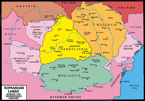
English: Central Europe during the short-term existence of Imre Thököly's Principality of Upper Hungary. - Habsburg and Ottoman territories, including Habsburg Kingdom of Hungary (Royal Hungary) and Habsburg Croatia, Ottoman vassal states (Wallachia, Moldavia, Transylvania, Principality of Upper Hungary (existed between 1682-1685), Montenegro, Ragusa) and Ottoman eyalets. The Ottoman expansion was asked by prince Imre Thököly in Upper Hungary (centered in present-day Slovakia) against the Habsburgs. The Ottoman Rule in Upper Hungary lasted only for 3 years. |
| 日期 | |
| 来源 | 自己的作品 |
| 作者 | PANONIAN |
| 其他版本 |
Derivative works of this file:
|
许可协议
[编辑]
我,本作品著作权人,特此采用以下许可协议发表本作品:
| 本作品采用知识共享CC0 1.0 通用公有领域贡献许可协议授权。 | |
| 采用本宣告发表本作品的人,已在法律允许的范围内,通过在全世界放弃其对本作品拥有的著作权法规定的所有权利(包括所有相关权利),将本作品贡献至公有领域。您可以复制、修改、传播和表演本作品,将其用于商业目的,无需要求授权。
|
References
[编辑]
- The Times History of Europe, Times Books, London, 2002.
- Peter Rokai - Zoltan Đere - Tibor Pal - Aleksandar Kasaš, Istorija Mađara, Beograd, 2002.
- Dr Dušan J. Popović, Srbi u Vojvodini, knjiga 1, Novi Sad, 1990.
- Dr D. J. Popović, Vojvodina u tursko doba, Zbornik "Vojvodina", knjiga I, Fototipsko izdanje, PROMETEJ, Novi Sad, 2008.
- Halil Inaldžik, Osmansko carstvo, Beograd, 2003.
- Petrit Imami, Srbi i Albanci kroz vekove, Beograd, 2000.
- File:Magyar- és Erdélyország 1629-ben (Pallas).jpg
- http://www.sulinet.hu/oroksegtar/data/telepulesek_ertekei/Erd/pages/images/221.jpg
- http://www.zum.de/whkmla/region/balkans/xsilistra.html
- http://www.euratlas.net/history/europe/1600/index.html
- http://www.freeweb.hu/csodaszarvas/galeria/galeria09/001/large_terkep12.jpg
- http://mek.niif.hu/01800/01885/html/cd5m/kepek/tortenelem/to212pe94185.jpg
- http://www.tortenelemklub.hu/galeries/6/Wesselényi%20legújabb.JPG[失效链接]
- http://farm4.static.flickr.com/3361/3657063110_1532418eb3.jpg
- http://www.camo.ch/Images/bpasaluk06.jpg archive copy at the Wayback Machine
- http://medlem.spray.se/zelenika/sandzak.jpg[失效链接]
- http://img375.imageshack.us/img375/7287/pasaluk2.png
- http://www.camo.ch/Images3/bhpasaluk.jpg archive copy at the Wayback Machine
- http://xxlworld.xx.ohost.de/povijest/slike/mape/1606.jpg
- http://www.hic.hr/books/pavlicev/images/s05.gif archive copy at the Wayback Machine
- http://api.wb21.net/images/a-torok-hodoltsag-kora-magyar-tortenelem/dr-blaskovics-jozsef,az-ujvari-ejalet-torok-adoosszeirasai.jpg archive copy at the Wayback Machine
.jpg)
文件历史
点击某个日期/时间查看对应时刻的文件。
| 日期/时间 | 缩略图 | 大小 | 用户 | 备注 | |
|---|---|---|---|---|---|
| 当前 | 2020年1月31日 (五) 12:48 | | 1,280 × 971(406 KB) | Claude Zygiel(留言 | 贡献) | Belergad eyalet cited in: Artin Hindoğlu's "Kurzwörterbuch Türkisch-Deutsch / Dictionnaire abrégé Turc-Français", Wien 1838, p. 125. |
| 2018年4月8日 (日) 21:35 |  | 1,280 × 971(390 KB) | Filederchest(留言 | 贡献) | info | |
| 2018年4月8日 (日) 19:06 |  | 1,280 × 971(378 KB) | Filederchest(留言 | 贡献) | Principality of Upper Hungary | |
| 2017年1月28日 (六) 15:19 |  | 1,543 × 1,170(146 KB) | PANONIAN(留言 | 贡献) | Reverted to version as of 20:47, 8 September 2011 (UTC) - this shows vassal principalities as separate states which they were not | |
| 2017年1月25日 (三) 20:52 |  | 1,543 × 1,170(135 KB) | Mélomène(留言 | 贡献) | Contrast | |
| 2011年9月8日 (四) 20:47 |  | 1,543 × 1,170(146 KB) | PANONIAN(留言 | 贡献) | corrected version | |
| 2011年9月5日 (一) 16:59 |  | 1,543 × 1,170(143 KB) | PANONIAN(留言 | 贡献) | {{Information |Description ={{en|1=Central Europe in 1683.}} |Source ={{own}} |Author =PANONIAN |Date =2011 |Permission = |other_versions = }} |
您不可以覆盖此文件。
文件用途
以下13个页面使用本文件:
- Atlas of Bosnia and Herzegovina
- Atlas of Croatia
- Atlas of Hungary
- Atlas of Moldova
- Atlas of Romania
- Atlas of Slovakia
- Atlas of Transylvania
- Atlas of Vojvodina
- User:J budissin/Uploads/BiH/2017 January 21-31
- User:J budissin/Uploads/BiH/2018 April 1-10
- User:J budissin/Uploads/BiH/2020 January 21-31
- Commons:Graphic Lab/Map workshop/Archive/2014
- Category:Budin Province, Ottoman Empire
全域文件用途
以下其他wiki使用此文件:
- an.wikipedia.org上的用途
- ar.wikipedia.org上的用途
- arz.wikipedia.org上的用途
- azb.wikipedia.org上的用途
- az.wikipedia.org上的用途
- ba.wikipedia.org上的用途
- be-tarask.wikipedia.org上的用途
- be.wikipedia.org上的用途
- bg.wikipedia.org上的用途
- bn.wikipedia.org上的用途
- bs.wikipedia.org上的用途
- ca.wikipedia.org上的用途
- cs.wikipedia.org上的用途
- de.wikipedia.org上的用途
- el.wikipedia.org上的用途
- en.wikipedia.org上的用途
查看此文件的更多全域用途。
元数据
分类:
- Maps of the history of Central Europe
- 1683 in Europe
- 1683 in Romania
- 1683
- Budin Province, Ottoman Empire
- Eyalet of Bosnia
- Eğri Province, Ottoman Empire
- Kanije Province, Ottoman Empire
- Kingdom of Hungary (1526–1867)
- Maps of Temeşvar Province, Ottoman Empire
- Maps of Wallachia
- Maps of eyalets of the Ottoman Empire
- Maps of the Habsburg Monarchy
- Maps of the Ottoman period in the history of Serbia
- Maps of the Principality of Moldavia
- Maps of the history of Banat
- Maps of the history of Bosnia and Herzegovina under Ottoman Empire
- Maps of the history of Croatia (1526–1918)
- Maps of the history of Early Modern Romania
- Maps of the history of Hungary (1526–1700)
- Maps of the history of Moldova
- Maps of the history of Slovakia
- Maps of the history of Transylvania
- Maps of the history of Vojvodina
- Maps of the history of the Ottoman Empire in the 1680s
- Maps of vassal states of the Ottoman Empire
- Principality of Transylvania
- Principality of Upper Hungary
- Romania in the 17th century
- Uyvar Province, Ottoman Empire
- Varat Province, Ottoman Empire