File:Chesapeake Bay (MODIS 2019-03-17).jpg

Original file (2,025 × 1,569 pixels, file size: 404 KB, MIME type: image/jpeg)
Captions
Captions
Summary[edit]
.jpg&action=edit§ion=1)
| Description |
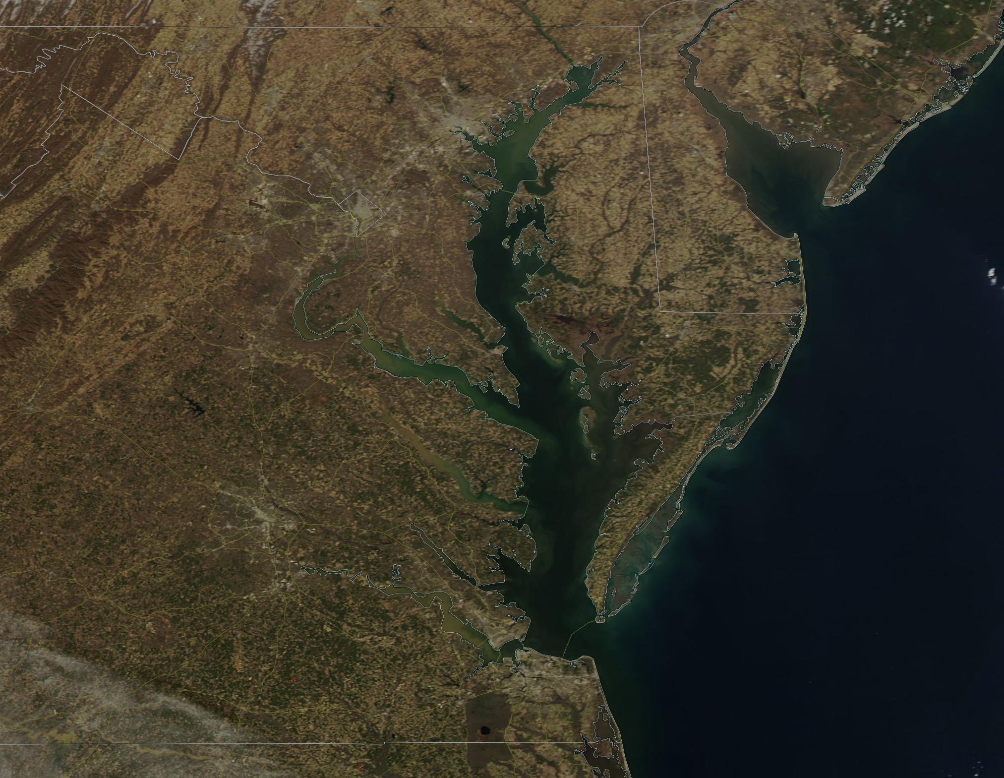
English: The third largest estuary in the world and the largest in the United States, the Chesapeake Bay stretches about 200 miles (329 km) from Havre de Grace, Maryland in the north to meet the ocean at Virginia Beach Virginia. The broad waters, which cover about 4,480 square miles, separate the Delmarva Peninsula from the mainland and the watershed covers parts of six states (New York, Pennsylvania, Maryland, Delaware, Virginia and West Virginia).
The importance of the Chesapeake Bay can’t be underestimated. Not only does it support a diverse, unique, and vitally important natural ecosystem, it also provides food, recreation, economic wealth, and water for about 18.2 million people living in the watershed of the Bay. About 10 million of these (more than half) live near or on the shoreline. The Chesapeake Bay was formed about 10,000 years ago when the massive glaciers of the last ice age melted and the rising ocean waters flooded the Susquehanna River Valley from present-day Virginia to north-eastern Maryland. The ancient river bed helps form a relatively deep trough along the bottom of the Bay, but the majority of the waters are surprisingly shallow, with an average depth of 21 feet (6.4 m). The Moderate Resolution Imaging Spectroradiometer (MODIS) on board NASA’s Aqua satellite acquired a true-color image of the Chesapeake Bay on March 12, 2019. |
||
| Date | Taken on 12 March 2019 | ||
| Source |
|
||
| Author | MODIS Land Rapid Response Team, NASA GSFC |
| This media is a product of the Aqua mission Credit and attribution belongs to the mission team, if not already specified in the "author" row |
Licensing[edit]
.jpg&action=edit§ion=2)
| This file is in the public domain in the United States because it was solely created by NASA. NASA copyright policy states that "NASA material is not protected by copyright unless noted". (See Template:PD-USGov, NASA copyright policy page or JPL Image Use Policy.) | ||
 |
Warnings:
|
File history
Click on a date/time to view the file as it appeared at that time.
| Date/Time | Thumbnail | Dimensions | User | Comment | |
|---|---|---|---|---|---|
| current | 03:27, 17 February 2024 | | 2,025 × 1,569 (404 KB) | OptimusPrimeBot (talk | contribs) | #Spacemedia - Upload of http://modis.gsfc.nasa.gov/gallery/images/image03172019_250m.jpg via Commons:Spacemedia |
You cannot overwrite this file.
File usage on Commons
There are no pages that use this file.
.jpg&oldid=852710018)