File:Chesapeake Bay at the Mouth of the Susquehanna River, Including Spesuite Island (2894697376).jpg

Original file (1,280 × 960 pixels, file size: 66 KB, MIME type: image/jpeg)
Captions
Captions
Summary
[edit].jpg&action=edit§ion=1)
| Description |
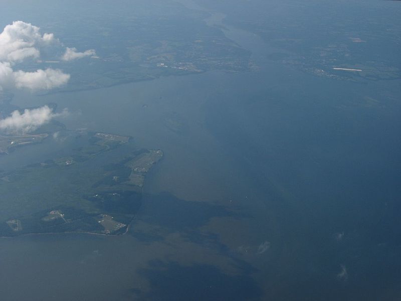
Chesapeake Bay is an estuary lying inland from the Atlantic Ocean surrounded by the states of Maryland and Virginia, the largest such body in the US. More than 150 rivers and streams flow into the Bay's 64,299 square miles (166,534 km2) drainage basin, which covers parts of six states (New York, Pennsylvania, Delaware, Maryland, Virginia, and West Virginia) and Washington, D.C. The Bay is approximately 200 miles (300 km) long from its northern headwaters in the Susquehanna River to its outlet in the Atlantic Ocean. It is 2.8 miles (4.5 km) wide at its narrowest (between Kent County's Plum Point near Newtown and the Harford County shore near Romney Creek) and 30 miles (50 km) at its widest (just south of the mouth of the Potomac River). Total shoreline including tributaries is 11,684 miles (18,804 km), representing a surface area of 4,479 square miles (11,601 km2). Average depth is 46 feet (14 m), reaching a maximum of 208 feet (63 m). The bay is spanned twice, in Maryland by the Chesapeake Bay Bridge from Sandy Point (near Annapolis) to Kent Island, and in Virginia by the Chesapeake Bay Bridge-Tunnel connecting Virginia Beach to Cape Charles. Known for both its beauty and bounty, the bay is becoming "emptier", with fewer crabs, oysters, and watermen in recent years. en.wikipedia.org/wiki/Chesapeake_Bay en.wikipedia.org/wiki/Wikipedia:Text_of_Creative_Commons_... |
| Date | |
| Source | Chesapeake Bay at the Mouth of the Susquehanna River, Including Spesuite Island |
| Author | Ken Lund from Reno, Nevada, USA |
| Camera location | | View this and other nearby images on: OpenStreetMap |
|---|
.jpg¶ms=039.543963_N_-076.091823_E_globe:Earth_type:camera_source:Flickr_&language=en)
Licensing
[edit].jpg&action=edit§ion=2)
- You are free:
- to share – to copy, distribute and transmit the work
- to remix – to adapt the work
- Under the following conditions:
- attribution – You must give appropriate credit, provide a link to the license, and indicate if changes were made. You may do so in any reasonable manner, but not in any way that suggests the licensor endorses you or your use.
- share alike – If you remix, transform, or build upon the material, you must distribute your contributions under the same or compatible license as the original.
| This image was originally posted to Flickr by Ken Lund at https://flickr.com/photos/75683070@N00/2894697376. It was reviewed on 3 December 2015 by FlickreviewR and was confirmed to be licensed under the terms of the cc-by-sa-2.0. |
File history
Click on a date/time to view the file as it appeared at that time.
| Date/Time | Thumbnail | Dimensions | User | Comment | |
|---|---|---|---|---|---|
| current | 22:05, 3 December 2015 | | 1,280 × 960 (66 KB) | INeverCry (talk | contribs) | Transferred from Flickr via Flickr2Commons |
You cannot overwrite this file.
File usage on Commons
There are no pages that use this file.
.jpg&oldid=888826926)