File:Cheshire UK locator map 2010.svg
Sautar la navigacion
Sautar la recèrca

Talha d'aquesta previsualizacion PNG per aquest fichièr SVG: 494 × 600 pixèls. Autras resolucions : 198 × 240 pixèls | 395 × 480 pixèls | 633 × 768 pixèls | 843 × 1 024 pixèls | 1 687 × 2 048 pixèls | 1 108 × 1 345 pixèls.
Fichièr d'origina (Fichièr SVG, resolucion de 1 108 × 1 345 pixèls, talha : 302 Ko)
Llegendes
Llegendes
Afegeix una explicació d'una línia del que representa aquest fitxer
Descripcion[modificar]
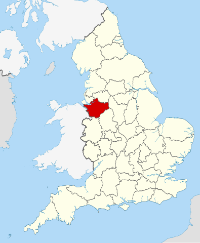
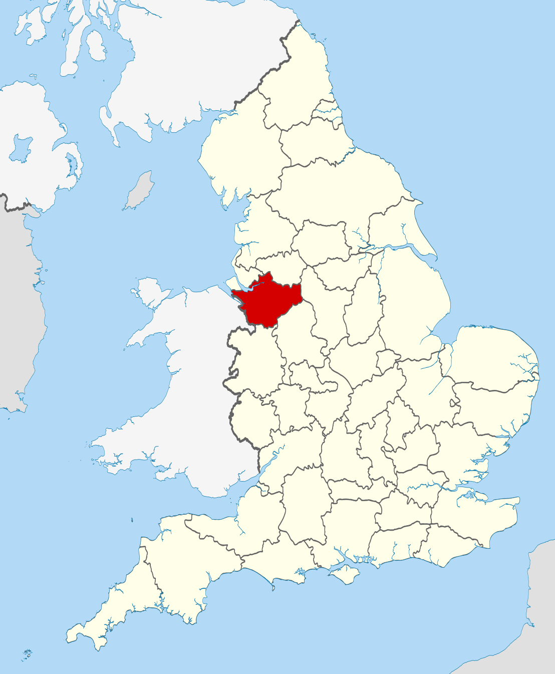
| Descripcion | Location of the ceremonial county of Cheshire within England. |
| Data | |
| Font |
National Geospatial-Intelligence Agency
|
| Autor | Nilfanion |
Publicat jos licéncia(s)[modificar]
Ieu, autor d'aquesta òbra, publiqui jos las licéncias seguentas:
Aqueste fichièr es jos licéncia Creative Commons licéncia generica atribucion-partiment a l'identic 3.0
- Sètz liure :
- de partejar – de copiar, distribuir e transmetre aquesta òbra
- d'adaptar – d'adaptar aquesta òbra
- Jos las condicions seguentas :
- atribucion – Vos cal atribuir aquesta òbra amb lo biais especificat per l'autor o lo concedent (mas pas dins un sens que suggerís que vos apròvan o qu'apròvan l'utilizacion d'aquesta òbra).
- partiment a l'identic – Se modificatz, transformatz, o vos basatz sus aquesta òbra, vos cal distribuir l'òbra resultanta jos la meteissa licéncia o una licéncia similara a aquesta.

|
Avètz la permission de copiar, distribuir e modificar aqueste document segon los tèrmes de la Licéncia de documentacion liura GNU, version 1.2 o mai recenta publicada per la Free Software Foundation; sens seccions inalterablas, sens tèxte de primièra pagina de tempa e sens tèxte de darrièra pagina de tempa. Un exemplar de la licéncia es inclús dins la seccion intitulada GNU Free Documentation License. |
Podètz causir la licéncia que volètz.

|
This is one of the images forming part of the Valued image set: Locator maps of the Ceremonial counties of England on Wikimedia Commons. The image set has been assessed under the valued image set criteria and is considered the most valued set on Commons within the scope:
Locator maps of the Ceremonial counties of England
You can see its nomination at Commons:Valued image candidates/Locator maps of English ceremonial counties. |
Istoric del fichièr
Clicar sus una data e una ora per veire lo fichièr tal coma èra a aqueste moment
| Data e ora | Miniatura | Dimensions | Utilizaire | Comentari | |
|---|---|---|---|---|---|
| actual | 23 novembre de 2010 a 22.31 | | 1 108 × 1 345 (302 Ko) | Nilfanion (discussion | contribucions) | == Summary == {{Information |Description=Location of the ceremonial county of Cheshire within England. |Source=Ordnance Survey [https://www.ordnancesurvey.co.uk/opendatadownload/products.html OpenData]: *County boundar |
Podètz pas remplaçar aqueste fichièr.
Paginas que contenon lo fichièr
Las paginas çaijós compòrtan aqueste imatge :
- Valued image set: Locator maps of the Ceremonial counties of England
- Commons:Valued image candidates/Locator maps of English ceremonial counties
- Category:Almshouses in Cheshire
- Category:Alumni by school in Cheshire
- Category:Births in Cheshire
- Category:Bridges in Cheshire
- Category:Cemeteries in Cheshire
- Category:Cheshire
- Category:Cheshire in the 1990s
- Category:Cheshire in the 19th century
- Category:Cheshire in the 2000s
- Category:Cheshire in the 2010s
- Category:Cheshire in the 20th century
- Category:Cheshire in the 21st century
- Category:Disused railway stations in Cheshire
- Category:Hospitals in Cheshire
- Category:Libraries in Cheshire
- Category:Maps of Cheshire
- Category:People of Cheshire
- Category:Populated places in Cheshire
- Category:Rail transport in Cheshire
- Category:Railway stations in Cheshire
- Category:Rivers of Cheshire
- Category:Roads in Cheshire
- Category:Sports in Cheshire
- Category:Towers in Cheshire
- Category:Views of Cheshire
- Category:Villages in Cheshire
- Category:Visitor attractions in Cheshire
- Category:Windmills in Cheshire
Usatge global del fichièr
Los autres wikis seguents utilizan aqueste imatge :
- Utilizacion sus af.wikipedia.org
- Utilizacion sus an.wikipedia.org
- Utilizacion sus ar.wikipedia.org
- Utilizacion sus arz.wikipedia.org
- Utilizacion sus ast.wikipedia.org
- Utilizacion sus be-tarask.wikipedia.org
- Utilizacion sus be.wikipedia.org
- Utilizacion sus bg.wikipedia.org
- Utilizacion sus br.wikipedia.org
- Utilizacion sus ca.wikipedia.org
- Utilizacion sus ceb.wikipedia.org
- Utilizacion sus cs.wikipedia.org
- Utilizacion sus de.wikipedia.org
- Utilizacion sus en.wikipedia.org
- Cheshire
- Gawsworth
- Langley, Cheshire
- Martinscroft
- Croft, Cheshire
- Birchwood Forest Park
- Culcheth Linear Park
- Lymm Dam
- Westy
- Bruche, Warrington
- Kerridge
- River Bollin
- Ollerton, Cheshire
- Wirral Hundred
- Tytherington, Cheshire
- Whiston Rural District
- Englesea-Brook
- Wilderspool
- Hermitage Green
- Lache
- Siddington, Cheshire
- Hough Green
- Ness Botanic Gardens
- Adlington, Cheshire
- Risley, Warrington
- River Lily
- Orford Park
- Chelford
- Template:Cheshire-geo-stub
- Agden, Cheshire West and Chester
- Agden, Cheshire East
- Aldersey
- Chester Castle (parish)
- Smallwood, Cheshire
- Cuddington Heath
Veire l'utilizacion globala d'aqueste fichièr.