File:Chios topographic map-en.svg
Jump to navigation
Jump to search

Size of this PNG preview of this SVG file: 800 × 582 pixels. Other resolutions: 320 × 233 pixels | 640 × 466 pixels | 1,024 × 745 pixels | 1,280 × 932 pixels | 2,560 × 1,863 pixels | 1,580 × 1,150 pixels.
Original file (SVG file, nominally 1,580 × 1,150 pixels, file size: 1.4 MB)
Captions
Captions
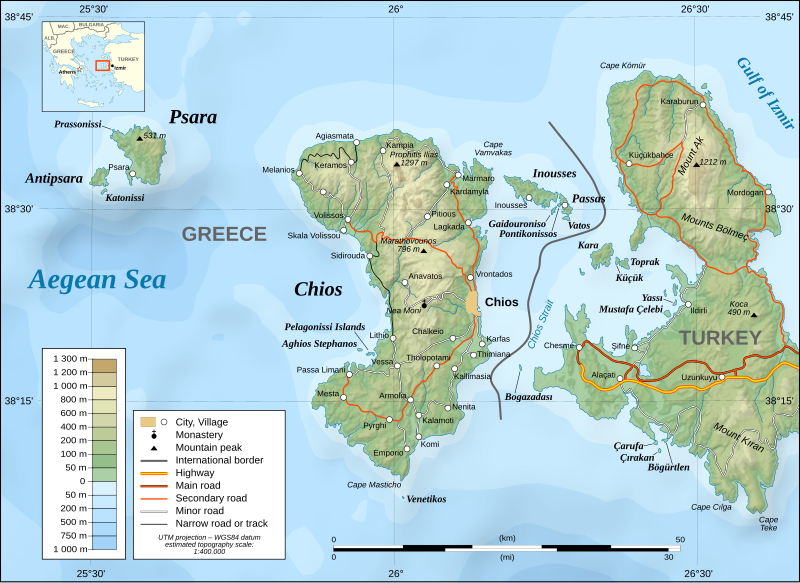
Chios topographic map
Summary[edit]
| Description |
[]
|
||
| Date | |||
| Source | Image:Chios topographic map-fr.svg | ||
| Author | Eric Gaba (translated by Pinacotecus) | ||
| Permission (Reusing this file) |
GFDL & CC-by-SA | ||
| Other versions |
[]
|


|
This SVG file contains embedded text that can be translated into your language, using any capable SVG editor, text editor or the SVG Translate tool. For more information see: About translating SVG files. |
Licensing[edit]
Eric Gaba, the copyright holder of this work, hereby publishes it under the following licenses:

|
Permission is granted to copy, distribute and/or modify this document under the terms of the GNU Free Documentation License, Version 1.2 or any later version published by the Free Software Foundation; with no Invariant Sections, no Front-Cover Texts, and no Back-Cover Texts. A copy of the license is included in the section entitled GNU Free Documentation License. |
This file is licensed under the Creative Commons Attribution-Share Alike 4.0 International, 3.0 Unported, 2.5 Generic, 2.0 Generic and 1.0 Generic license.
Attribution: Eric Gaba
- You are free:
- to share – to copy, distribute and transmit the work
- to remix – to adapt the work
- Under the following conditions:
- attribution – You must give appropriate credit, provide a link to the license, and indicate if changes were made. You may do so in any reasonable manner, but not in any way that suggests the licensor endorses you or your use.
- share alike – If you remix, transform, or build upon the material, you must distribute your contributions under the same or compatible license as the original.
You may select the license of your choice.
File history
Click on a date/time to view the file as it appeared at that time.
| Date/Time | Thumbnail | Dimensions | User | Comment | |
|---|---|---|---|---|---|
| current | 17:15, 27 January 2022 | | 1,580 × 1,150 (1.4 MB) | Pinacotecus (talk | contribs) | File uploaded using svgtranslate tool (https://svgtranslate.toolforge.org/). Added translation for en. |
| 17:10, 27 January 2022 |  | 1,580 × 1,150 (1.4 MB) | Pinacotecus (talk | contribs) | File uploaded using svgtranslate tool (https://svgtranslate.toolforge.org/). Added translation for en. | |
| 16:55, 27 January 2022 |  | 1,580 × 1,150 (1.4 MB) | Pinacotecus (talk | contribs) | Uploaded a work by Eric Gaba (translated by Pinacotecus (talk)) from Image:Chios topographic map-fr.svg with UploadWizard |
You cannot overwrite this file.
File usage on Commons
The following 7 pages use this file:
File usage on other wikis
The following other wikis use this file:
- Usage on bg.wikipedia.org
- Usage on el.wikipedia.org
- Usage on en.wikipedia.org
- Usage on hr.wikipedia.org
- Usage on ig.wikipedia.org
- Usage on incubator.wikimedia.org
- Usage on it.wikipedia.org
- Usage on lij.wikipedia.org
- Usage on pl.wikipedia.org
- Usage on sl.wikipedia.org