File:Circumnavigation marchand.svg
Jump to navigation
Jump to search

Size of this PNG preview of this SVG file: 800 × 389 pixels. Other resolutions: 320 × 156 pixels | 640 × 311 pixels | 1,024 × 498 pixels | 1,280 × 623 pixels | 2,560 × 1,246 pixels | 1,266 × 616 pixels.
Original file (SVG file, nominally 1,266 × 616 pixels, file size: 455 KB)
Captions
Captions
Add a one-line explanation of what this file represents
Summary
[edit]| Description |
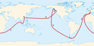
English: Map of the french navigator Étienne Marchand's voyage (1791-1792). 1. Marseille Français : Carte du voyage du navigateur français Étienne Marchand (1791-1792). 1. Marseille |
||
| Date | |||
| Source |
Own work. Background:
|
||
| Author | Sémhur (talk) | ||
| Attribution (required by the license) | © Sémhur / Wikimedia Commons / | ||
| SVG | W3C-validity not checked.
|

Licensing
[edit]
I, the copyright holder of this work, hereby publish it under the following licenses:
| Copyleft: This work of art is free; you can redistribute it and/or modify it according to terms of the Free Art License. You will find a specimen of this license on the Copyleft Attitude site as well as on other sites. |
This file is licensed under the Creative Commons Attribution-Share Alike Attribution-Share Alike 4.0 International, 3.0 Unported, 2.5 Generic, 2.0 Generic and 1.0 Generic license.
- You are free:
- to share – to copy, distribute and transmit the work
- to remix – to adapt the work
- Under the following conditions:
- attribution – You must give appropriate credit, provide a link to the license, and indicate if changes were made. You may do so in any reasonable manner, but not in any way that suggests the licensor endorses you or your use.
- share alike – If you remix, transform, or build upon the material, you must distribute your contributions under the same or compatible license as the original.
You may select the license of your choice.
File history
Click on a date/time to view the file as it appeared at that time.
| Date/Time | Thumbnail | Dimensions | User | Comment | |
|---|---|---|---|---|---|
| current | 20:07, 3 April 2007 | | 1,266 × 616 (455 KB) | Sémhur (talk | contribs) | {{Information |Description= {{fr|Carte du voyage du navigateur français fr:Étienne Marchand (1791-1793).<br /> 1. Marseille 2. Iles du Cap Vert 3. Iles Marquises 4. Achat des fourrures : Archipel Alexandre, iles de la Reine Charlotte, ile Vancouver |
You cannot overwrite this file.
File usage on Commons
There are no pages that use this file.
File usage on other wikis
The following other wikis use this file:
- Usage on en.wikipedia.org
- Usage on es.wikipedia.org
- Usage on fr.wikipedia.org