File:Clear Skies over Patagonia (MODIS 2022-01-23).jpg
Jump to navigation
Jump to search

Size of this preview: 800 × 560 pixels. Other resolutions: 320 × 224 pixels | 640 × 448 pixels | 1,024 × 717 pixels | 1,280 × 896 pixels | 2,560 × 1,792 pixels | 7,477 × 5,234 pixels.
Original file (7,477 × 5,234 pixels, file size: 3.4 MB, MIME type: image/jpeg)
Captions
Captions
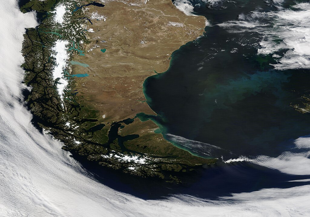
On January 20, 2022, the Moderate Resolution Imaging Spectroradiometer (MODIS) on board NASA’s Terra satellite acquired a dramatic true-color image of Patagonia surrounded by a swirl of cloud.
Summary
[edit].jpg&action=edit§ion=1)
| Description |
English: On January 20, 2022, the Moderate Resolution Imaging Spectroradiometer (MODIS) on board NASA’s Terra satellite acquired a dramatic true-color image of Patagonia surrounded by a swirl of cloud. On this clear summer day, almost all of Patagonia can be seen, from Chile’s verdant Pacific coast, to the snow-and-glacier-topped Andes Mountains, then to the dry scrublands and coastal lowlands of Argentina. Only a small part of the western-most coastlines are hidden under fingers of low cloud (fog).
Spanning more than 1 million square kilometers, Patagonia is surrounded by the Pacific Ocean in the west and the Atlantic Ocean in the east. The southern tip, Tierra del Fuego, is crossed by the Strait of Magellan, the Beagle Channel, and the Drake Passage to the south. Several glacial lakes sit on the eastern edge of the Andes, shining brightly in various shades of blue. Such a widespread clear view of southern South America is rather rare, thanks to the year-round and frequent passage of storms. Tierra del Fuego sits in a belt of prevailing westerly winds where blustery and cloud-filled days are the norm as high- and low-pressure systems drift eastward. The Andes Mountains, sitting along the border between Chile (west) and Argentina (east) adds to inland cloudiness. When eastward-blowing wind passing over the Pacific Ocean encounter the tall Andes, it is forced upward. As moist air rises and cools, it condenses into cloud. |
||
| Date | Taken on 20 January 2022 | ||
| Source |
Clear Skies over Patagonia (direct link)
|
||
| Author | MODIS Land Rapid Response Team, NASA GSFC |
| This media is a product of the Terra mission Credit and attribution belongs to the mission team, if not already specified in the "author" row |
Licensing
[edit].jpg&action=edit§ion=2)
| This file is in the public domain in the United States because it was solely created by NASA. NASA copyright policy states that "NASA material is not protected by copyright unless noted". (See Template:PD-USGov, NASA copyright policy page or JPL Image Use Policy.) | ||
 |
Warnings:
|
File history
Click on a date/time to view the file as it appeared at that time.
| Date/Time | Thumbnail | Dimensions | User | Comment | |
|---|---|---|---|---|---|
| current | 22:20, 9 January 2024 | | 7,477 × 5,234 (3.4 MB) | OptimusPrimeBot (talk | contribs) | #Spacemedia - Upload of http://modis.gsfc.nasa.gov/gallery/images/image01232022_250m.jpg via Commons:Spacemedia |
You cannot overwrite this file.
File usage on Commons
There are no pages that use this file.
.jpg&oldid=840071157)