File:Colonial Africa 1913 map.svg
跳至導覽
跳至搜尋

此 SVG 檔案的 PNG 預覽的大小:644 × 600 像素。 其他解析度:258 × 240 像素 | 515 × 480 像素 | 824 × 768 像素 | 1,099 × 1,024 像素 | 2,198 × 2,048 像素 | 1,390 × 1,295 像素。
原始檔案 (SVG 檔案,表面大小:1,390 × 1,295 像素,檔案大小:660 KB)
說明
說明
添加單行說明來描述出檔案所代表的內容
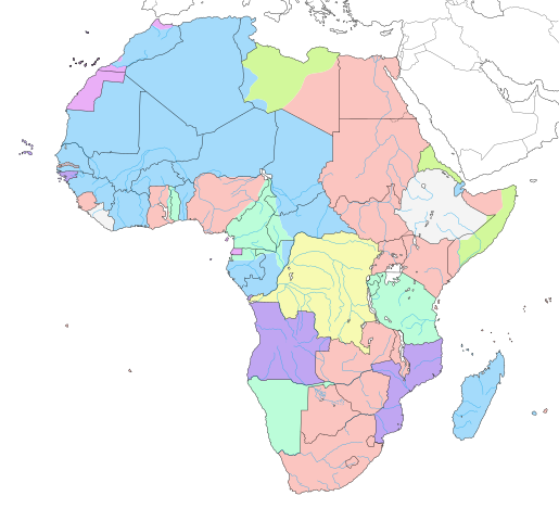
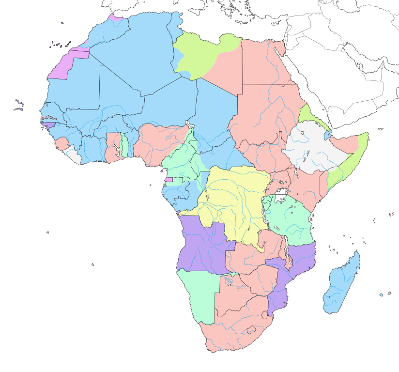
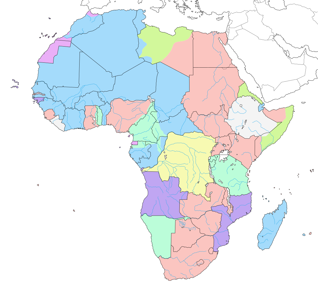
Map of colonial Africa around 1913, on the current borders.
BEL
|
GER
|
ESP
|
FRA
|
GBR
|
ITA
|
PRT
|
Independent
| |
|---|---|---|---|---|---|---|---|---|
العربية: |
بلجيكا | ألمانيا | اسبانيا | فرنسا | بريطانيا | إيطاليا | البرتغال | |
Azərbaycanca: |
Belçika | Almaniya | İspaniya | Fransa | Böyük Britaniya | İtaliya | Portuqaliya | |
Беларуская: |
Бельгія | Германія | Іспанія | Францыя | Вялікабрытанія | Італія | Партугалія | |
Български: |
Белгия | Германия | Испания | Франция | Великобритания | Италия | Португалия | |
বাংলা: |
বেলজিয়াম | জার্মানি | স্পেন | ফ্রান্স | যুক্তরাজ্য | ইতালি | পর্তুগাল | |
Català: |
Bèlgica | Alemanya | Espanya | França | Gran Bretanya | Itàlia | Portugal | |
Čeština: |
Belgie | Německo | Španělsko | Francie | Velká Británie | Itálie | Portugalsko | |
Cymraeg: |
Gwlad Belg | Yr Almaen | Sbaen | Ffrainc | Prydain Fawr | Yr Eidal | Portiwgal | |
Dansk: |
Belgien | Tyskland | Spanien | Frankrig | Storbritannien | Italien | Portugal | |
Deutsch: |
Belgien | Deutschland | Spanien | Frankreich | Großbritannien | Italien | Portugal | Unabhängige Staaten |
Ελληνικά: |
Βέλγιο | Γερμανία | Ισπανία | Γαλλία | Μεγάλη Βρετανία | Ιταλία | Πορτογαλία | |
English: |
Belgium | Germany | Spain | France | United Kingdom | Italy | Portugal | Independent States |
Esperanto: |
Belgio | Germanio | Hispanio | Francio | Britio | Italio | Portugalio | |
Español: |
Bélgica | Alemania | España | Francia | Gran Bretaña | Italia | Portugal | Estados independientes |
Eesti: |
Belgia | Saksamaa | Hispaania | Prantsusmaa | Suurbritannia | Itaalia | Portugal | |
Euskara: |
Belgika | Alemania | Espainia | Frantzia | Britainia Handia | Italia | Portugal | |
Suomi: |
Belgia | Saksa | Espanja | Ranska | Iso-Britannia | Italia | Portugalia | |
Français : |
Belgique | Allemagne | Espagne | France | Grande-Bretagne | Italie | Portugal | États indépendants |
Gaeilge: |
An Bheilg | An Ghearmáin | An Spáinn | An Fhrainc | An Ríocht Aontaithe | An Iodáil | An Phortáingeil | |
Galego: |
Bélxica | Alemaña | España | Francia | Gran Bretaña | Italia | Portugal | |
Hrvatski: |
Belgija | Njemačka | Španjolska | Francuska | Velika Britanija | Italija | Portugal | |
Magyar: |
Belgium | Németország | Spanyolország | Franciország | Nagy-Britania | Olaszország | Portugália | |
Հայերեն: |
Բելգիա | Գերմանիա | Իսպանիա | Ֆրանսիա | Միացյալ Թագավորություն | Իտալիա | Պորտուգալիա | |
Bahasa Indonesia: |
Belgia | Jerman | Spanyol | Prancis | Britania Raya | Ítalia | Portugal | Negara independen |
Íslenska: |
Belgía | Þýskaland | Spánn | Frakkland | Stóra Bretland | Ítalía | Portúgal | |
Italiano: |
Belgio | Germania | Spagna | Francia | Regno Unito | Italia | Portogallo | |
ქართული: |
ბელგია | გერმანია | ესპანეთი | საფრანგეთი | გაერთიანებული სამეფო | იტალია | პორტუგალია | |
한국어: |
벨기에 | 독일 | 스페인 | 프랑스 | 영국 | 이탈리아 | 포르투갈 | |
Lietuvių: |
Belgija | Vokietija | Ispanija | Prancūzija | D. Britanija | Italija | Portugalija | |
Latviešu: |
Beļģija | Vācija | Spānija | Francija | Lielbritānija | Itālija | Portugāle | |
Македонски: |
Белгија | Германија | Шпанија | Франција | Велика Британија | Италија | Португалија | |
Malti: |
Belġju | Ġermanja | Spanja | Franza | Gran Brittanja | Italja | Portugall | |
Nederlands: |
België | Duitsland | Spanje | Frankrijk | Groot-Brittannië | Italië | Portugal | Onafhankelijke gebieden |
Norsk bokmål: |
Belgia | Tyskland | Spania | Frankrike | Storbritannia | Italia | Portugal | |
Polski: |
Belgia | Niemcy | Hiszpania | Francja | Wielka Brytania | Włochy | Portugalia | |
Português: |
Bélgica | Alemanha | Espanha | França | Grã-Bretanha | Itália | Portugal | Estados independentes |
Română: |
Belgia | Germania | Spania | Franţa | Regatul Unit | Italia | Portugalia | |
Русский: |
Бельгия | Германия | Испания | Франция | Великобритания | Италия | Португалия | |
Slovenčina: |
Belgicko | Nemecko | Španielsko | Francúzsko | Veľká Británia | Taliansko | Portugalsko | |
Slovenščina: |
Belgija | Nemčija | Španija | Francija | Velika Britanija | Italija | Portugalska | |
Shqip: |
Belgjika | Gjermanija | Spanja | Franca | Britanisë së Madhe | Italia | Portugalia | |
Српски / srpski: |
Белгија | Немачка | Шпанија | Француска | Велика Британија | Италија | Португалија | |
Svenska: |
Belgien | Tyskland | Spanien | Frankrike | Storbritannien | Italien | Portugal | |
Kiswahili: |
Ubelgiji | Ujerumani | Hispania | Ufaransa | Ufalme wa Muungano | Italia | Ureno | |
Türkçe: |
Belçika | Almanya | İspanya | Fransa | Büyük Britanya | İtalya | Portekiz | |
Українська: |
Бельгія | Німеччина | Іспанія | Франція | Велика Британія | Італія | Португалія | |
Tiếng Việt: |
Bỉ | Đức | Tây Ban Nha | Pháp | Anh | Ý | Bồ Đào Nha | |
中文: |
比利时 | 德国 | 西班牙 | 法国 | 英国 | 意大利 | 葡萄牙 |
摘要
[編輯]| 描述 |
English: Map of colonial Africa as in 1913, with modern borders.
Note: The limits of the areas of control may not be perfectly accurate due to the imprecision of the reference maps. Deutsch: Karte des kolonialen Afrikas von 1913 mit modernen Grenzen.
Notiz: Die Grenzen der Kontrollbereiche sind aufgrund der Ungenauigkeit der Referenzkarten möglicherweise nicht ganz genau. Italiano: Mappa dell'Africa coloniale come nel 1913, con confini moderni.
Nota: I limiti delle aree di controllo potrebbero non essere perfettamente precisi a causa dell'imprecisione delle mappe di riferimento. Español: Mapa del África colonial como en 1913, con fronteras modernas.
Nota: Los límites de las áreas de control pueden no ser perfectamente precisos debido a la imprecisión de los mapas de referencia. Français : Carte de l'Afrique coloniale en 1913, avec frontières modernes. Note : Les limites des zones de contrôle peuvent ne pas être tout à fait exactes en raison de l'imprécision des cartes de référence utilisées. |
||
| 日期 | 2007年六月, updated/corrected 2011-07 | ||
| 來源 |
自己的作品 (Original text: Own work ;)
|
||
| 作者 | Eric Gaba (Sting - fr:Sting) | ||
| 授權許可 (重用此檔案) |
|
||
| 其他版本 |
[]
|
||
| SVG開發 |


.svg)

_ast.svg)


-es.svg)
_mapa.png)

_eu.svg)


.svg)

.jpg)


-sr.png)


.svg)


.svg)

授權條款
[編輯]
Eric Gaba,此作品的版權所有人,決定用以下授權條款發佈本作品:

|
已授權您依據自由軟體基金會發行的無固定段落、封面文字和封底文字GNU自由文件授權條款1.2版或任意後續版本,對本檔進行複製、傳播和/或修改。該協議的副本列在GNU自由文件授權條款中。 |
| 此檔案採用共享創意 姓名標示-相同方式分享 3.0 未在地化版本授權條款。 | ||
| 姓名標示: Eric Gaba – Wikimedia Commons user: Sting | ||
| ||
| 已新增授權條款標題至此檔案,作為GFDL授權更新的一部份。 |
此檔案採用創用CC 姓名標示-相同方式分享 2.5 通用版授權條款。
姓名標示: Eric Gaba – Wikimedia Commons user: Sting
- 您可以自由:
- 分享 – 複製、發佈和傳播本作品
- 重新修改 – 創作演繹作品
- 惟需遵照下列條件:
- 姓名標示 – 您必須指名出正確的製作者,和提供授權條款的連結,以及表示是否有對內容上做出變更。您可以用任何合理的方式來行動,但不得以任何方式表明授權條款是對您許可或是由您所使用。
- 相同方式分享 – 如果您利用本素材進行再混合、轉換或創作,您必須基於如同原先的相同或兼容的條款,來分布您的貢獻成品。
您可以選擇您需要的授權條款。
檔案歷史
點選日期/時間以檢視該時間的檔案版本。
| 日期/時間 | 縮圖 | 尺寸 | 用戶 | 備註 | |
|---|---|---|---|---|---|
| 目前 | 2019年4月24日 (三) 14:29 | | 1,390 × 1,295(660 KB) | Sting(對話 | 貢獻) | Added surrounding landmasses ; waterbodies in white ; colour adjustment |
| 2018年7月5日 (四) 13:29 |  | 1,390 × 1,295(586 KB) | M3tainfo(對話 | 貢獻) | Black borders with stroke width and removed local file refs | |
| 2014年3月3日 (一) 00:36 |  | 1,390 × 1,295(587 KB) | Sting(對話 | 貢獻) | Reverted to version as of 13:06, 19 December 2013 | |
| 2014年3月2日 (日) 16:07 |  | 1,390 × 1,295(590 KB) | Knyaz-1988(對話 | 貢獻) | New version | |
| 2014年3月2日 (日) 16:05 |  | 1,390 × 1,295(587 KB) | Knyaz-1988(對話 | 貢獻) | New version | |
| 2014年3月2日 (日) 16:02 |  | 1,390 × 1,295(587 KB) | Knyaz-1988(對話 | 貢獻) | New version | |
| 2013年12月19日 (四) 13:06 |  | 1,390 × 1,295(587 KB) | Sting(對話 | 貢獻) | Correction : Fernando Pó/Bioko under Spanish domination | |
| 2011年7月14日 (四) 21:27 |  | 1,390 × 1,295(587 KB) | Sting(對話 | 貢獻) | Sudan/South Sudan 2011-07 border update ; correction on the area of Cape Juby | |
| 2007年6月7日 (四) 07:23 |  | 1,390 × 1,295(642 KB) | Sting(對話 | 貢獻) | Colour correction | |
| 2007年6月7日 (四) 06:52 |  | 1,390 × 1,295(642 KB) | Sting(對話 | 貢獻) | Background |
無法覆蓋此檔案。
檔案用途
下列63個頁面有用到此檔案:
- Atlas of Africa
- Atlas of Nigeria
- User:Sting/Gallery: Regional maps
- Commons talk:Project Mapmaking Wiki Standards/Archive01
- File:Africa1913 fr.png
- File:Africa Colonial.png
- File:Africa colonization 1914.PNG
- File:Africacolony.PNG
- File:African colonization map (swedish).jpg
- File:Afrika 1913.png
- File:Afrika 1914.png
- File:Afrika 1914 - sr.png
- File:Afrika Kolonisation Farben.png
- File:Afrika koloniala 1914an.png
- File:ColonialAfrica-da.png
- File:ColonialAfrica-no.png
- File:ColonialAfrica.png
- File:ColonialAfrica Zh.PNG
- File:Colonial Africa 1800 map.png
- File:Colonial Africa 1870 map-fr.png
- File:Colonial Africa 1870 map.png
- File:Colonial Africa 1900 map-fr.png
- File:Colonial Africa 1900 map.png
- File:Colonial Africa 1913, pre WWI-es.svg
- File:Colonial Africa 1913, pre WWI.svg
- File:Colonial Africa 1913 German East Africa map.svg
- File:Colonial Africa 1913 German South West Africa map.svg
- File:Colonial Africa 1913 Germany map.svg
- File:Colonial Africa 1913 Gold Coast map.svg
- File:Colonial Africa 1913 Kamerun map.svg
- File:Colonial Africa 1913 Nigeria North map.svg
- File:Colonial Africa 1913 Nigeria South map.svg
- File:Colonial Africa 1913 Togoland map.svg
- File:Colonial Africa 1913 map.svg
- File:Colonial Africa 1914 map-he.png
- File:Colonial Africa 1914 map.png
- File:Colonial Africa 1923 map.png
- File:Colonial Africa Nigeria 1913 map.svg
- File:Colonial Africa Tunisia 1913 map.svg
- File:Colonial N.Africa 1913 map.svg
- File:Colonias en Africa (1914) mapa.png
- File:Colonies in Africa in 1914.jpg
- File:Decolonization of Africa PL.PNG
- File:FeizhouZhimindi.png
- File:Hui-chiu sit-bin-te 1914.png
- File:Kolonie Afryka 1947.PNG
- File:Kolonie afryka 1914.PNG
- File:Kolonien-Afrikas.svg
- File:Kolonisation Afrikas.png
- File:Map of Africa in 1939.png
- File:Map of Colonial Africa (1914)-sr.png
- File:Mapa del África colonial (1914).svg
- File:Mapa del África colonial (1914) ast.svg
- File:Mapa del África colonial (1914) eu.svg
- File:Mapa del África colonial (1939).svg
- File:Mapa del África colonial (1947).svg
- File:Mapa mudo del África colonial (1914).svg
- File:Mapa polityczna Afryki (1914)-es.svg
- File:Mapa polityczna Afryki (1914).svg
- File:Southern Rhodesia 1914.png
- File:ΑποικιακήΑφρική.png
- File:Колонии на Африка през 1914.png
- Template:Other versions/Colonial Africa
.svg)
全域檔案使用狀況
以下其他 wiki 使用了這個檔案:
- af.wikipedia.org 的使用狀況
- als.wikipedia.org 的使用狀況
- an.wikipedia.org 的使用狀況
- ar.wikipedia.org 的使用狀況
- ast.wikipedia.org 的使用狀況
- av.wikipedia.org 的使用狀況
- az.wikipedia.org 的使用狀況
- ba.wikipedia.org 的使用狀況
- bg.wikipedia.org 的使用狀況
- br.wikipedia.org 的使用狀況
- ca.wikipedia.org 的使用狀況
- ca.wikibooks.org 的使用狀況
- cs.wikipedia.org 的使用狀況
- da.wikipedia.org 的使用狀況
- de.wikipedia.org 的使用狀況
- diq.wikipedia.org 的使用狀況
- el.wikipedia.org 的使用狀況
- en.wikipedia.org 的使用狀況
檢視此檔案的更多全域使用狀況。