File:Colorado 82.svg
Aller à la navigation
Aller à la recherche

Taille de cet aperçu PNG pour ce fichier SVG : 600 × 600 pixels. Autres résolutions : 240 × 240 pixels | 480 × 480 pixels | 768 × 768 pixels | 1 024 × 1 024 pixels | 2 048 × 2 048 pixels | 601 × 601 pixels.
Fichier d’origine (Fichier SVG, nominalement de 601 × 601 pixels, taille : 7 kio)
Légendes
Légendes
Ajoutez en une ligne la description de ce que représente ce fichier
Description[modifier]
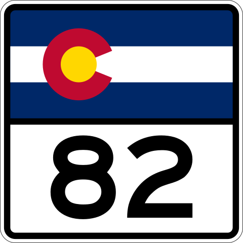
| Description | 600 mm by 600 mm (24 in by 24 in) Colorado shield, made to the specifications of the Manual on Uniform Traffic Control Devices (MUTCD), 2003 Edition (sign M1-5). Uses the Roadgeek 2005 fonts. (United States law does not permit the copyrighting of typeface designs, and the fonts are meant to be copies of a U.S. Government-produced work anyway.) |
| Date | |
| Source | Travail personnel |
| Auteur | Fredddie, originally by User:Atanamir, User:TwinsMetsFan, or User:Pzoxicuvybtnrm among others |
Conditions d’utilisation[modifier]
This file is in the public domain because it comes from the Colorado Supplement to the Federal Manual on Uniform Traffic Control Devices, which states that "the Transportation Commission of Colorado adopted the Federal Manual on Uniform Traffic Control Devices 2009, (MUTCD) for use in Colorado." It also states that "the Colorado Supplement has been established to adjust and interpret where necessary for the proper and lawful application of the MUTCD in Colorado in compliance with state statutes, and to address traffic regulatory situations not provided for in the MUTCD." The federal MUTCD states specifically on its page I-1 that:
No provisions of the supplement have adjusted or interpreted this provision of the MUTCD. |
Historique du fichier
Cliquer sur une date et heure pour voir le fichier tel qu'il était à ce moment-là.
| Date et heure | Vignette | Dimensions | Utilisateur | Commentaire | |
|---|---|---|---|---|---|
| actuel | 17 mars 2012 à 23:41 | | 601 × 601 (7 kio) | Fredddie (d | contributions) | |
| 17 avril 2007 à 15:07 |  | 390 × 394 (7 kio) | Scott5114 (d | contributions) | {{PD-self}} 082 |
Vous ne pouvez pas remplacer ce fichier.
Utilisations locales du fichier
Les 3 pages suivantes utilisent ce fichier :
Utilisations du fichier sur d’autres wikis
Les autres wikis suivants utilisent ce fichier :
- Utilisation sur azb.wikipedia.org
- Utilisation sur de.wikipedia.org
- Utilisation sur en.wikipedia.org
- Pitkin County, Colorado
- Lake County, Colorado
- Garfield County, Colorado
- Eagle County, Colorado
- Basalt, Colorado
- List of state highways in Colorado
- Independence Pass (Colorado)
- Colorado State Highway 82
- Top of the Rockies National Scenic Byway
- U.S. Route 6 in Colorado
- List of highways numbered 82
- Wikipedia:WikiProject U.S. Roads/Redirects/Colorado
- Interstate 70 in Colorado
- Colorado State Highway 133
- Southern Rocky Mountains
- Colorado State Highway 83
- Maroon Creek Bridge
- List of mountain passes in Colorado
- U.S. Route 24 in Colorado
- Colorado State Highway 79
- List of Rocky Mountain passes on the continental divide
- List of passes of the Rocky Mountains
- User:Central Corridor/VelociRFTA
- Template:VelociRFTA
- User:Central Corridor/List of Roaring Fork Transportation Authority bus routes
- User:ChryZ MUC/mountainpasseslist
- Collegiate Peaks Scenic Byway
- West Elk Loop Scenic and Historic Byway
- Utilisation sur en.wikivoyage.org
- Utilisation sur es.wikipedia.org
- Utilisation sur et.wikipedia.org
- Utilisation sur fa.wikipedia.org
- Utilisation sur fr.wikipedia.org
- Utilisation sur mr.wikipedia.org
- Utilisation sur uz.wikipedia.org
- Utilisation sur zh-min-nan.wikipedia.org
- Utilisation sur zh.wikipedia.org