File:Colorado River South of Canyonlands National Park, Utah (9179262029).jpg

Original file (4,000 × 3,000 pixels, file size: 2.32 MB, MIME type: image/jpeg)
Captions
Captions
Summary[edit]
.jpg&action=edit§ion=1)
| Description |
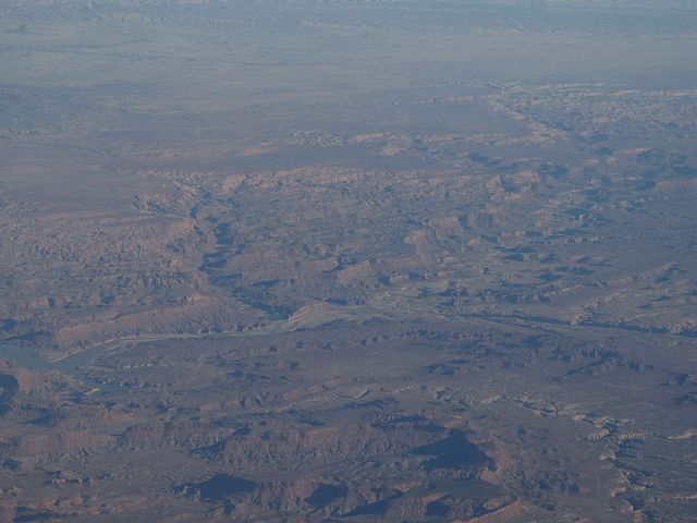
Canyonlands National Park is a U.S. National Park located in southeastern Utah near the town of Moab and preserves a colorful landscape eroded into countless canyons, mesas and buttes by the Colorado River, the Green River, and their respective tributaries. The park is divided into four districts: the Island in the Sky, the Needles, the Maze, and the rivers themselves. While these areas share a primitive desert atmosphere, each retains its own character. Two large river canyons are carved into the Colorado Plateau by the Colorado River and Green River. Author Edward Abbey, a frequent visitor, described the Canyonlands as "the most weird, wonderful, magical place on earth—there is nothing else like it anywhere." Canyonlands is a popular recreational destination. On average 440,039 people visited the park each year. The geography of the park is well suited to a number of different recreational uses. Hikers, mountain bikers, backpackers, and four-wheelers all enjoy traveling the rugged, remote trails within the Park. Rafters and kayakers float the calm stretches of the Green River and Colorado River above the Confluence. Below the Confluence, Cataract Canyon contains powerful whitewater rapids, similar to those found in the Grand Canyon. However, since there is no large impoundment on the Colorado River above Canyonlands National Park, river flow through the Confluence is determined by snowmelt, not management. As a result, and in combination with Cataract Canyon's unique graben geology, this stretch of river offers the largest whitewater in North America in heavy snow years. en.wikipedia.org/wiki/Canyonlands_National_Park en.wikipedia.org/wiki/Wikipedia:Text_of_Creative_Commons_... |
| Date | Taken on 26 June 2013, 20:00 |
| Source | Colorado River South of Canyonlands National Park, Utah |
| Author | Ken Lund from Reno, Nevada, USA |
| Camera location | | View this and other nearby images on: OpenStreetMap |
|---|
.jpg¶ms=037.812047_N_-110.451693_E_globe:Earth_type:camera_source:Flickr_&language=en)
Licensing[edit]
.jpg&action=edit§ion=2)
- You are free:
- to share – to copy, distribute and transmit the work
- to remix – to adapt the work
- Under the following conditions:
- attribution – You must give appropriate credit, provide a link to the license, and indicate if changes were made. You may do so in any reasonable manner, but not in any way that suggests the licensor endorses you or your use.
- share alike – If you remix, transform, or build upon the material, you must distribute your contributions under the same or compatible license as the original.
| This image was originally posted to Flickr by Ken Lund at https://flickr.com/photos/75683070@N00/9179262029. It was reviewed on 3 December 2015 by FlickreviewR and was confirmed to be licensed under the terms of the cc-by-sa-2.0. |
File history
Click on a date/time to view the file as it appeared at that time.
| Date/Time | Thumbnail | Dimensions | User | Comment | |
|---|---|---|---|---|---|
| current | 22:50, 3 December 2015 | | 4,000 × 3,000 (2.32 MB) | INeverCry (talk | contribs) | Transferred from Flickr via Flickr2Commons |
You cannot overwrite this file.
File usage on Commons
There are no pages that use this file.
.jpg&oldid=865642581)