File:Colors in Northern South America (MODIS 2021-01-07).jpg

Original file (2,218 × 1,931 pixels, file size: 618 KB, MIME type: image/jpeg)
Captions
Captions
Summary
[edit].jpg&action=edit§ion=1)
| Description |
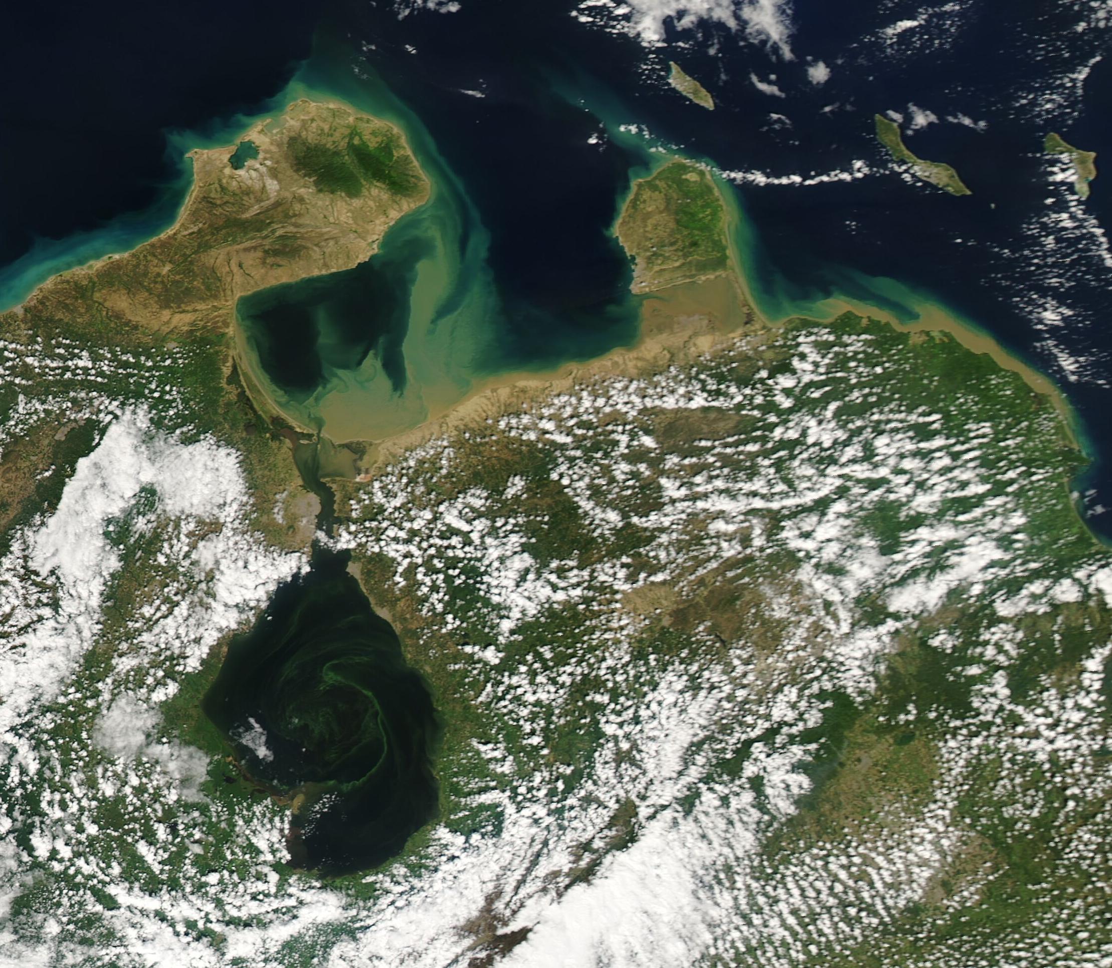
English: On January 3, 2021, the Moderate Resolution Imaging Spectroradiometer (MODIS) on board NASA’s Aqua satellite captured a colorful true-color image of the northern-most tip of South America.
Columbia’s Guajira Peninsula (west) and the Paraguan Peninsula of Venezuela (east) wear a halo of tan and green while a large tan-to-green plume stretches across the Gulf of Venezuela. These stunning colors are the result of sediment. As mud-colored sediment washes off the coastlines by rain, tidal erosion, or carried by rivers and inlets, it floats near the top of the water and appears a muddy-tan. As the sediment begins to sink under water, its reflectivity changes and it looks green from space. The large sediment plume primarily originates from the Tablazo Strait, which connects the Gulf of Venezuela to Lake Maracaibo. A large embayment, brackish Lake Maracaibo receives freshwater inflow and sediment from many rivers, including the Catatumbo River located near the southern end of the lake. In turn, the lake water flows into the Gulf of Venezuela—often carrying a heavy load of sediment. Lake Maracaibo carries color of its own—an infusion of green swirls decorates the dark waters. These colors are likely caused by floating vegetation rather than sediment. Every so often, when the normally stratified waters mix, conditions in the lake become ideal for plant growth. While it is not possible to discern the type of plant from true-color images, blooms of duckweed occur with regularity in Lake Maracaibo. |
||
| Date | Taken on 3 January 2021 | ||
| Source |
Colors in Northern South America (direct link)
|
||
| Author | MODIS Land Rapid Response Team, NASA GSFC |
| This media is a product of the Aqua mission Credit and attribution belongs to the mission team, if not already specified in the "author" row |
Licensing
[edit].jpg&action=edit§ion=2)
| This file is in the public domain in the United States because it was solely created by NASA. NASA copyright policy states that "NASA material is not protected by copyright unless noted". (See Template:PD-USGov, NASA copyright policy page or JPL Image Use Policy.) | ||
 |
Warnings:
|
File history
Click on a date/time to view the file as it appeared at that time.
| Date/Time | Thumbnail | Dimensions | User | Comment | |
|---|---|---|---|---|---|
| current | 18:08, 30 January 2024 | | 2,218 × 1,931 (618 KB) | OptimusPrimeBot (talk | contribs) | #Spacemedia - Upload of http://modis.gsfc.nasa.gov/gallery/images/image01072021_250m.jpg via Commons:Spacemedia |
You cannot overwrite this file.
File usage on Commons
There are no pages that use this file.
.jpg&oldid=847253196)