File:Compass rose.png
Jump to navigation
Jump to search
No higher resolution available.
Compass_rose.png (340 × 345 pixels, file size: 72 KB, MIME type: image/png)
Captions
Captions
Add a one-line explanation of what this file represents
Summary[edit]
| Description |
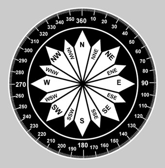
English: By using the meridians, direction from one point to another can be measured in degrees, in a clockwise direction from true north. To indicate a course to be followed in flight, draw a line on the chart from the point of departure to the destination and measure the angle which this line forms with a meridian. Direction is expressed in degrees, as shown by the compass rose |
| Source | Fig 08-04, Advisory Circular AC 61-23C, Pilot's Handbook of Aeronautical Knowledge, U.S. en:Federal Aviation Administration, Revised 1997. |
| Author | Someone at the US FAA |

|
This graph image could be re-created using vector graphics as an SVG file. This has several advantages; see Commons:Media for cleanup for more information. If an SVG form of this image is available, please upload it and afterwards replace this template with
{{vector version available|new image name}}.
It is recommended to name the SVG file “Compass rose.svg”—then the template Vector version available (or Vva) does not need the new image name parameter. |
Licensing[edit]
This image or file is a work of a Federal Aviation Administration employee, taken or made as part of that person's official duties. As a work of the U.S. federal government, the image is in the public domain in the United States.
|
 |
Original upload log[edit]
The original description page was here. All following user names refer to en.wikipedia.
- 2007-01-21 01:52 Dhaluza 340×345×8 (74028 bytes) By using the meridians, direction from one point to another can be measured in degrees, in a clockwise direction from true north. To indicate a course to be followed in flight, draw a line on the chart from the point of departure to the destination and me
File history
Click on a date/time to view the file as it appeared at that time.
| Date/Time | Thumbnail | Dimensions | User | Comment | |
|---|---|---|---|---|---|
| current | 03:08, 30 November 2007 | | 340 × 345 (72 KB) | File Upload Bot (Magnus Manske) (talk | contribs) | {{BotMoveToCommons|en.wikipedia}} {{Information |Description={{en|By using the meridians, direction from one point to another can be measured in degrees, in a clockwise direction from true north. To indicate a course to be followed in flight, draw a line |
You cannot overwrite this file.
File usage on Commons
There are no pages that use this file.
File usage on other wikis
The following other wikis use this file:
- Usage on en.wikibooks.org
- Usage on ja.wikipedia.org
- Usage on th.wikipedia.org