File:Connecticut River Map.png
Aller à la navigation
Aller à la recherche
Taille de cet aperçu : 448 × 600 pixels. Autres résolutions : 179 × 240 pixels | 578 × 774 pixels.
Fichier d’origine (578 × 774 pixels, taille du fichier : 58 kio, type MIME : image/png)
Légendes
Légendes
Ajoutez en une ligne la description de ce que représente ce fichier
Description
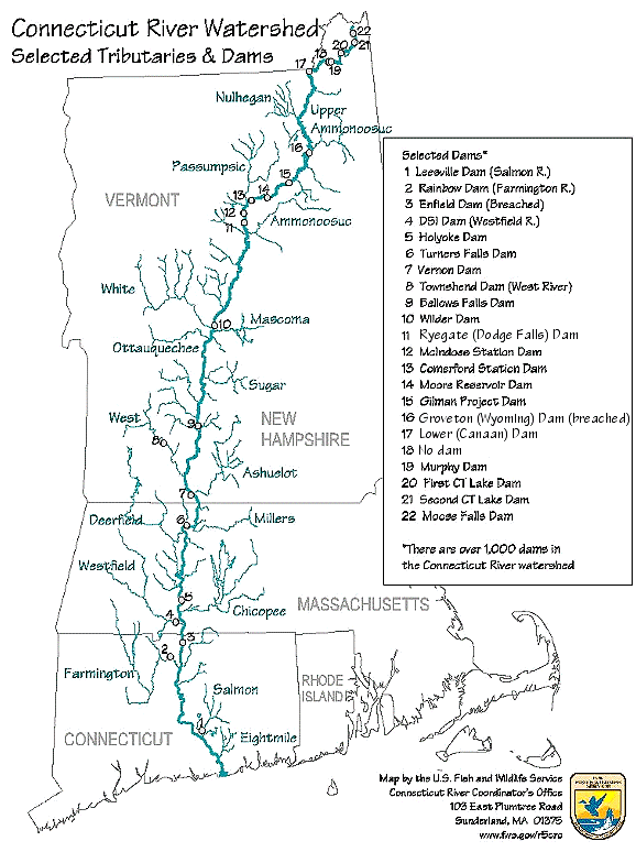
[modifier]| Description | Map of the Connecticut River, New England, USA. This map was prepared by the United States Fish and Wildlife Service, and as a product of the United States Government is in the public domain and not subject to copyright restrictions. | |||
| Source | Originally from en.wikipedia; description page is/was here. Original uploader was Daderot sur Wikipédia anglais | |||
| Auteur | USGov | |||
| Autorisation (Réutilisation de ce fichier) |
|


|
Cette image (de type transport map) devrait être recréée dans un format vectoriel, en tant que fichier SVG. Cela offrirait plusieurs avantages : voir Commons:Media for cleanup pour plus d'informations. Si une version SVG de cette image est déjà disponible, merci de bien vouloir l'envoyer. Après cela, remplacez ce modèle par {{vector version available|nouveau nom d'image.svg}}.
|
Journal des téléversements d’origine
[modifier]
| Date et heure | Dimensions | Utilisateur | Commentaire |
|---|---|---|---|
| 6 janvier 2008, 16:02:00 | 580 × 778 (61343 bytes) | Gridge (d · contributions) | {{Information |Description=Map of the Connecticut River, New England, USA. This map was prepared by the United States Fish and Wildlife Service, and as a product of the United States Government is in the public domain and not subject to copyright restrict |
Historique du fichier
Cliquer sur une date et heure pour voir le fichier tel qu'il était à ce moment-là.
| Date et heure | Vignette | Dimensions | Utilisateur | Commentaire | |
|---|---|---|---|---|---|
| actuel | 10 mars 2024 à 08:26 | | 578 × 774 (58 kio) | Lojwe (d | contributions) | Cropped < 1 % horizontally, 1 % vertically using CropTool with precise mode. |
| 25 novembre 2014 à 04:45 |  | 580 × 778 (74 kio) | GifTagger (d | contributions) | Bot: Converting file to superior PNG file. (Source: Connecticut_River_Map.gif). This GIF was problematic due to non-greyscale color table. |
Vous ne pouvez pas remplacer ce fichier.
Utilisations locales du fichier
Les 5 pages suivantes utilisent ce fichier :
Utilisations du fichier sur d’autres wikis
Les autres wikis suivants utilisent ce fichier :
- Utilisation sur bg.wikipedia.org
- Utilisation sur cs.wikipedia.org
- Utilisation sur da.wikipedia.org
- Utilisation sur de.wikipedia.org
- Utilisation sur en.wikipedia.org
- Utilisation sur es.wikipedia.org
- Utilisation sur fi.wikipedia.org
- Utilisation sur fr.wikipedia.org
- Utilisation sur fy.wikipedia.org
- Utilisation sur he.wikipedia.org
- Utilisation sur incubator.wikimedia.org
- Utilisation sur it.wikipedia.org
- Utilisation sur ja.wikipedia.org
- Utilisation sur nl.wikipedia.org
- Utilisation sur pt.wikipedia.org
- Utilisation sur ru.wikipedia.org
- Utilisation sur simple.wikipedia.org
- Utilisation sur sv.wikipedia.org
- Utilisation sur sw.wikipedia.org
- Utilisation sur ta.wikipedia.org
- Utilisation sur th.wikipedia.org
- Utilisation sur www.wikidata.org
- Utilisation sur zh.wikipedia.org