File:Connecticut River Map.png
跳转到导航
跳转到搜索
本预览的尺寸:448 × 600像素。 其他分辨率:179 × 240像素 | 578 × 774像素。
原始文件 (578 × 774像素,文件大小:58 KB,MIME类型:image/png)
说明
说明
添加一行文字以描述该文件所表现的内容
摘要[编辑]
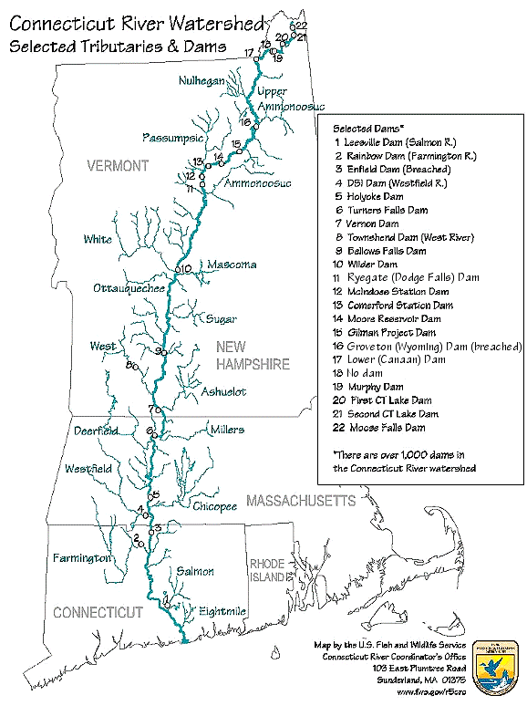
| 描述 | Map of the Connecticut River, New England, USA. This map was prepared by the United States Fish and Wildlife Service, and as a product of the United States Government is in the public domain and not subject to copyright restrictions. | |||
| 来源 | Originally from en.wikipedia; description page is/was here. Original uploader was 英语维基百科的Daderot | |||
| 作者 | USGov | |||
| 授权 (二次使用本文件) |
|


|
此transport map图片可使用矢量图形重新创建为SVG文件。这具有很多好处;更多信息请参见共享资源:待清理媒体。如果存在此图片的SVG格式,请将其上传,然后将此模板替换为
{{vector version available|新图片名称}}。
建议您将SVG命名为“Connecticut River Map.svg”,这样在使用Vector version available(或Vva)模板时就不需要填写新图片名称参数。 |
原始上传日志[编辑]
| 日期/时间 | 大小 | 用户 | 备注 |
|---|---|---|---|
| 2008年1月6日, 16:02:00 | 580 × 778 (61343 bytes) | Gridge (留言 · 贡献) | {{Information |Description=Map of the Connecticut River, New England, USA. This map was prepared by the United States Fish and Wildlife Service, and as a product of the United States Government is in the public domain and not subject to copyright restrict |
文件历史
点击某个日期/时间查看对应时刻的文件。
| 日期/时间 | 缩略图 | 大小 | 用户 | 备注 | |
|---|---|---|---|---|---|
| 当前 | 2024年3月10日 (日) 08:26 | | 578 × 774(58 KB) | Lojwe(留言 | 贡献) | Cropped < 1 % horizontally, 1 % vertically using CropTool with precise mode. |
| 2014年11月25日 (二) 04:45 |  | 580 × 778(74 KB) | GifTagger(留言 | 贡献) | Bot: Converting file to superior PNG file. (Source: Connecticut_River_Map.gif). This GIF was problematic due to non-greyscale color table. |
您不可以覆盖此文件。
文件用途
以下5个页面使用本文件:
全域文件用途
以下其他wiki使用此文件:
- bg.wikipedia.org上的用途
- cs.wikipedia.org上的用途
- da.wikipedia.org上的用途
- de.wikipedia.org上的用途
- en.wikipedia.org上的用途
- es.wikipedia.org上的用途
- fi.wikipedia.org上的用途
- fr.wikipedia.org上的用途
- fy.wikipedia.org上的用途
- he.wikipedia.org上的用途
- incubator.wikimedia.org上的用途
- it.wikipedia.org上的用途
- ja.wikipedia.org上的用途
- nl.wikipedia.org上的用途
- pt.wikipedia.org上的用途
- ru.wikipedia.org上的用途
- simple.wikipedia.org上的用途
- sv.wikipedia.org上的用途
- sw.wikipedia.org上的用途
- ta.wikipedia.org上的用途
- th.wikipedia.org上的用途
- www.wikidata.org上的用途
- zh.wikipedia.org上的用途