File:Control of the island of Borneo.png
跳转到导航
跳转到搜索

本预览的尺寸:539 × 600像素。 其他分辨率:216 × 240像素 | 431 × 480像素 | 690 × 768像素 | 1,080 × 1,202像素。
原始文件 (1,080 × 1,202像素,文件大小:207 KB,MIME类型:image/png)
说明
说明
添加一行文字以描述该文件所表现的内容
摘要
[编辑]
| 描述 |
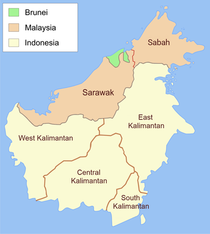
English: Administrative map of Borneo in English label. |
| 日期 | |
| 来源 | 自己的作品, translate from File:Administrative map of Borneo (Indonesian).png |
| 作者 | Ranking Update |
| 授权 (二次使用本文件) |
我,本作品著作权人,特此采用以下许可协议发表本作品: 本文件采用知识共享署名-相同方式共享 3.0 未本地化版本许可协议授权。
|
.png)

|
此map图片可使用矢量图形重新创建为SVG文件。这具有很多好处;更多信息请参见共享资源:待清理媒体。如果存在此图片的SVG格式,请将其上传,然后将此模板替换为
{{vector version available|新图片名称}}。
建议您将SVG命名为“Control of the island of Borneo.svg”,这样在使用Vector version available(或Vva)模板时就不需要填写新图片名称参数。 |
文件历史
点击某个日期/时间查看对应时刻的文件。
| 日期/时间 | 缩略图 | 大小 | 用户 | 备注 | |
|---|---|---|---|---|---|
| 当前 | 2021年7月20日 (二) 10:02 | | 1,080 × 1,202(207 KB) | Davidelit(留言 | 贡献) | Reverted to version as of 09:57, 20 July 2021 (UTC) |
| 2021年7月20日 (二) 10:01 |  | 1,080 × 1,202(232 KB) | Davidelit(留言 | 贡献) | Reverted to version as of 17:28, 4 August 2017 (UTC) | |
| 2021年7月20日 (二) 09:57 |  | 1,080 × 1,202(207 KB) | Davidelit(留言 | 贡献) | Provinces as during the Confrontation, i.e. no North Kalimantan | |
| 2017年8月4日 (五) 17:28 |  | 1,080 × 1,202(232 KB) | Night Lantern(留言 | 贡献) | fixed font | |
| 2017年7月16日 (日) 20:01 |  | 1,200 × 1,335(146 KB) | Maproom(留言 | 贡献) | Updated name of northernmost province | |
| 2013年8月1日 (四) 22:03 |  | 1,200 × 1,335(207 KB) | Muffin Wizard(留言 | 贡献) | User created page with UploadWizard |
您不可以覆盖此文件。
文件用途
以下2个页面使用本文件:
全域文件用途
以下其他wiki使用此文件:
- ar.wikipedia.org上的用途
- bn.wikipedia.org上的用途
- en.wikipedia.org上的用途
- es.wikipedia.org上的用途
- fr.wikipedia.org上的用途
- incubator.wikimedia.org上的用途
- it.wikipedia.org上的用途
- ms.wikipedia.org上的用途
- my.wikipedia.org上的用途
- pcd.wikipedia.org上的用途
- pt.wikipedia.org上的用途
- sr.wikipedia.org上的用途
- szy.wikipedia.org上的用途
- vi.wikipedia.org上的用途