File:Cook Strait, New Zealand (MODIS 2021-07-10).jpg
Jump to navigation
Jump to search

Size of this preview: 734 × 600 pixels. Other resolutions: 294 × 240 pixels | 588 × 480 pixels | 940 × 768 pixels | 1,254 × 1,024 pixels | 2,507 × 2,048 pixels | 3,403 × 2,780 pixels.
Original file (3,403 × 2,780 pixels, file size: 1.57 MB, MIME type: image/jpeg)
Captions
Captions
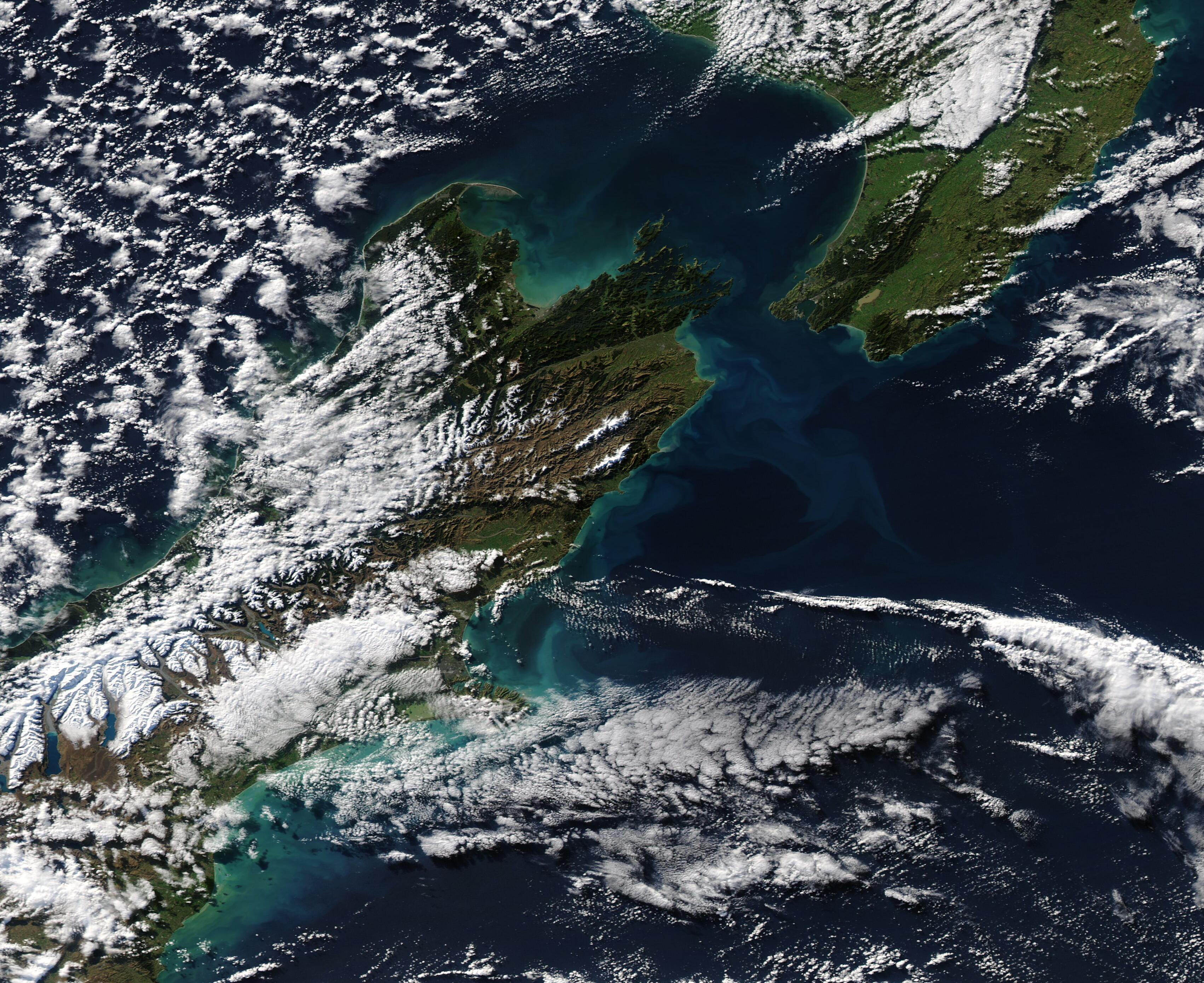
A patch of clear sky allowed the Moderate Resolution Imaging Spectroradiometer (MODIS) on board NASA’s Aqua satellite to acquire a dramatic view of the Cook Strait on July 8, 2021.
Summary[edit]
.jpg&action=edit§ion=1)
| Description |
English: A patch of clear sky allowed the Moderate Resolution Imaging Spectroradiometer (MODIS) on board NASA’s Aqua satellite to acquire a dramatic view of the Cook Strait on July 8, 2021. Several banks of clouds stretch over the South Pacific Ocean and the western coast of New Zealand’s North Island while cloud overlies the snow atop the rugged ridges of the mountains on South Island. Open-celled clouds hover over the Tasman Sea.
Approximately 20 miles (32 km) long and only 14 miles (22.5 km) wide at the narrowest point, the small Cook Strait remains a formidable body of water. This narrow strip of sea, which separates the North and South Islands of New Zealand, has a reputation as one of the world’s roughest stretches of water. The two islands lie within the “Roaring Forties”, a belt of strong winds that circle the globe at about 40 degrees south. The gusting westerlies hit the islands and their mountainous terrain, and are forced into to the strait, which acts something like a huge wind tunnel. While ferries safely cross the Strait, on windy days the three-hour trip from Wellington Harbor, North Island, and Queen Charlotte Sound in the South Island has been described as “something like riding a bucking bronco”-a trip not for the faint of heart. |
||
| Date | Taken on 8 July 2021 | ||
| Source |
Cook Strait, New Zealand (direct link)
|
||
| Author | MODIS Land Rapid Response Team, NASA GSFC |
| This media is a product of the Aqua mission Credit and attribution belongs to the mission team, if not already specified in the "author" row |
Licensing[edit]
.jpg&action=edit§ion=2)
| This file is in the public domain in the United States because it was solely created by NASA. NASA copyright policy states that "NASA material is not protected by copyright unless noted". (See Template:PD-USGov, NASA copyright policy page or JPL Image Use Policy.) | ||
 |
Warnings:
|
File history
Click on a date/time to view the file as it appeared at that time.
| Date/Time | Thumbnail | Dimensions | User | Comment | |
|---|---|---|---|---|---|
| current | 17:39, 30 January 2024 | | 3,403 × 2,780 (1.57 MB) | OptimusPrimeBot (talk | contribs) | #Spacemedia - Upload of http://modis.gsfc.nasa.gov/gallery/images/image07102021_250m.jpg via Commons:Spacemedia |
You cannot overwrite this file.
File usage on Commons
There are no pages that use this file.
.jpg&oldid=847253211)