File:Cooks Karte von Neufundland.jpg
跳转到导航
跳转到搜索

本预览的尺寸:615 × 599像素。 其他分辨率:246 × 240像素 | 492 × 480像素 | 788 × 768像素 | 1,051 × 1,024像素 | 1,500 × 1,462像素。
原始文件 (1,500 × 1,462像素,文件大小:521 KB,MIME类型:image/jpeg)
说明
说明
添加一行文字以描述该文件所表现的内容
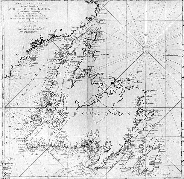
| 描述 | A general chart of the island of Newfoundland. Surveyed by James Cook and Michael Lane, and "publish'd according to Act of Parliament by Thomas Jefferys Geographer to the King, 1775." |
| 日期 | |
| 来源 | originally uploaded to en.wikipedia by Jcmurphy on 23 Apr 2005; copied from "Courtesy of the Centre for Newfoundland Studies, Memorial University of Newfoundland, St. John's, Newfoundland." |
| 作者 | Michael Lane and James Cook |
| 授权 (二次使用本文件) |
Public domain because of age |
|
本作品在其来源国以及其他著作权期限是作者逝世后100年或以下的国家和地区属于公有领域。 | |
| 本文件已被确认为免除已知的著作权法限制(包括所有相关权利)。 | |
文件历史
点击某个日期/时间查看对应时刻的文件。
| 日期/时间 | 缩略图 | 大小 | 用户 | 备注 | |
|---|---|---|---|---|---|
| 当前 | 2006年1月6日 (五) 19:10 | | 1,500 × 1,462(521 KB) | Schaengel89~commonswiki(留言 | 贡献) | {{Information| |Description =A general chart of the island of Newfoundland. Surveyed by James Cook and Michael Lane, and "publish'd according to Act of Parliament by Thomas Jefferys Geographer to the King, 1775." |Source =originally yuploaded to |
您不可以覆盖此文件。
文件用途
以下页面使用本文件:
全域文件用途
以下其他wiki使用此文件:
- bs.wikipedia.org上的用途
- ca.wikipedia.org上的用途
- de.wikipedia.org上的用途
- en.wikipedia.org上的用途
- en.wikivoyage.org上的用途
- eo.wikipedia.org上的用途
- es.wikipedia.org上的用途
- fi.wikipedia.org上的用途
- fr.wikipedia.org上的用途
- fur.wikipedia.org上的用途
- ga.wikipedia.org上的用途
- gl.wikipedia.org上的用途
- he.wikipedia.org上的用途
- hy.wikipedia.org上的用途
- ia.wikipedia.org上的用途
- it.wikipedia.org上的用途
- ja.wikipedia.org上的用途
- ka.wikipedia.org上的用途
- ko.wikipedia.org上的用途
- la.wikipedia.org上的用途
- li.wikipedia.org上的用途
- lt.wikipedia.org上的用途
- mk.wikipedia.org上的用途
- ne.wikipedia.org上的用途
- no.wikipedia.org上的用途
- oc.wikipedia.org上的用途
- pl.wikipedia.org上的用途
- pl.wiktionary.org上的用途
查看此文件的更多全域用途。