File:Copper-alloy post-medieval jetton (FindID 803160).jpg
Jump to navigation
Jump to search
Size of this preview: 800 × 445 pixels. Other resolutions: 320 × 178 pixels | 640 × 356 pixels | 1,024 × 569 pixels | 1,280 × 712 pixels | 2,560 × 1,423 pixels | 7,645 × 4,251 pixels.
Original file (7,645 × 4,251 pixels, file size: 3.07 MB, MIME type: image/jpeg)
Captions
Captions
Add a one-line explanation of what this file represents
| Camera location | | View this and other nearby images on: OpenStreetMap |
|---|
.jpg¶ms=053.877603_N_-001.888747_E_globe:Earth_type:camera_alt:97.05727_source:exif_heading:119.52&language=en)
Summary
[edit].jpg&action=edit§ion=1)
| Copper-alloy post-medieval jetton | |||
|---|---|---|---|
| Photographer |
The Portable Antiquities Scheme, Helen Geake, 2017-01-05 17:45:43 |
||
| Title |
Copper-alloy post-medieval jetton |
||
| Description |
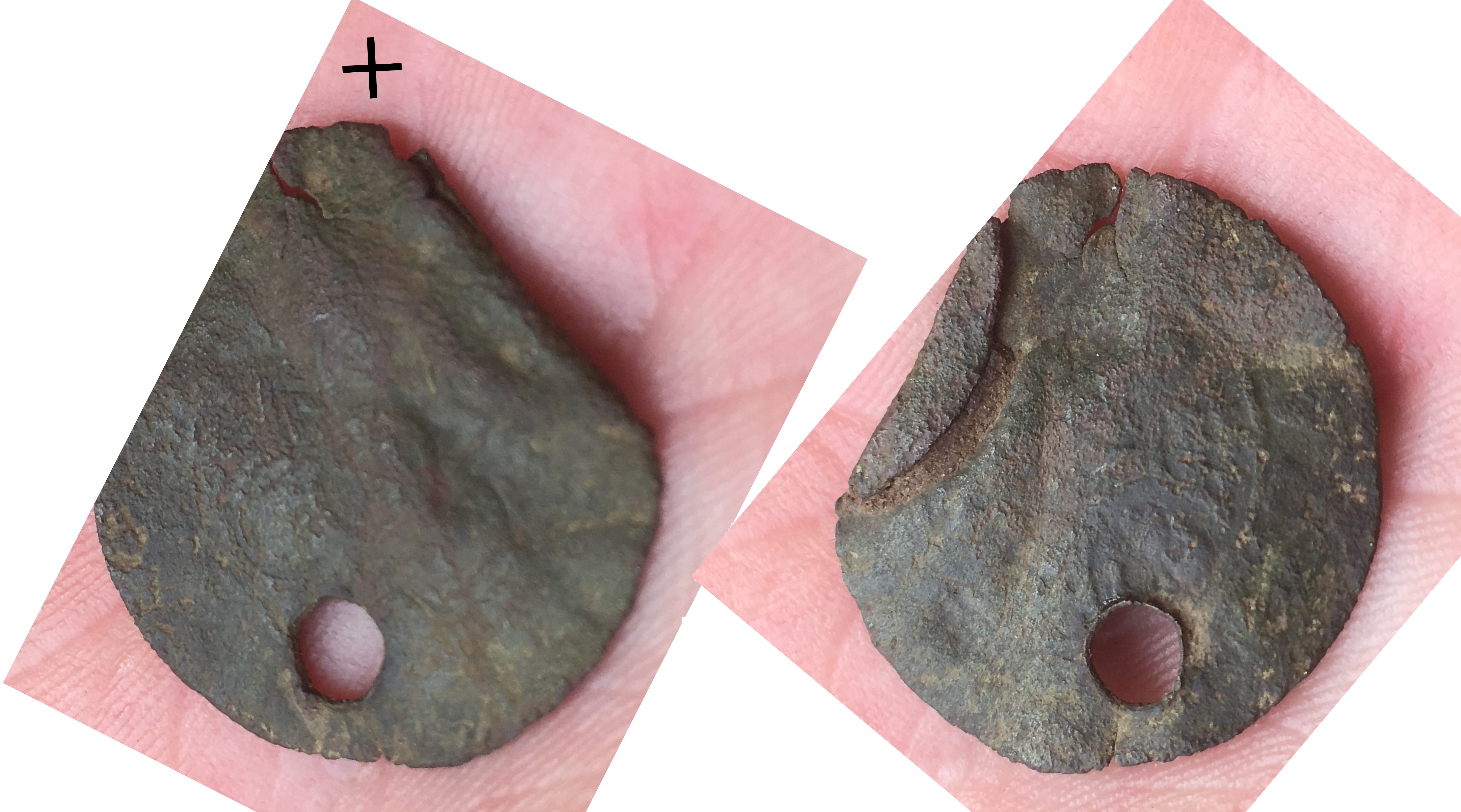
English: A copper-alloy post-medieval rose/orb jetton, probably issued by the Nuremberg Master Hans Krauwinckel II, active c.1586-1635 AD. Legend not visible on either side. This jetton has been pierced with a 3.8mm circular hole in the position of 6 o'clock, cutting through both legend and central motif. The jetton has been folded over 12 o'clock to 2 o'clock (when the jetton is viewed with the orb face uppermost). Weight 1.2g, diameter 24.91. Compare SUSS-088C0D.
In the photo, the black cross is put above the position of the cross on the orb. |
||
| Depicted place | (County of findspot) North Yorkshire | ||
| Date | between 1586 and 1635 | ||
| Accession number |
FindID: 803160 Old ref: PUBLIC-169D9E Filename: PUBLIC169D9E.jpg |
||
| Credit line |
|
||
| Source |
https://finds.org.uk/database/ajax/download/id/596016 Catalog: https://finds.org.uk/database/images/image/id/596016/recordtype/artefacts archive copy at the Wayback Machine Artefact: https://finds.org.uk/database/artefacts/record/id/803160 |
||
| Permission (Reusing this file) |
Attribution License | ||
| Object location | | View this and other nearby images on: OpenStreetMap |
|---|
.jpg¶ms=054.193800_N_-000.388924_E_globe:Earth_class:object_type:object__&language=en)
Licensing
[edit].jpg&action=edit§ion=2)
This file is licensed under the Creative Commons Attribution 2.0 Generic license.
Attribution: The Portable Antiquities Scheme
- You are free:
- to share – to copy, distribute and transmit the work
- to remix – to adapt the work
- Under the following conditions:
- attribution – You must give appropriate credit, provide a link to the license, and indicate if changes were made. You may do so in any reasonable manner, but not in any way that suggests the licensor endorses you or your use.
File history
Click on a date/time to view the file as it appeared at that time.
| Date/Time | Thumbnail | Dimensions | User | Comment | |
|---|---|---|---|---|---|
| current | 09:40, 19 December 2018 | | 7,645 × 4,251 (3.07 MB) | Fæ (talk | contribs) | Portable Antiquities Scheme, NFAHG, FindID: 803160, post medieval, page 2602, batch count 2653 |
You cannot overwrite this file.
File usage on Commons
The following page uses this file:
.jpg)
.jpg&oldid=868172526)