File:Copy of a map military reconnaissance Dep't Va. - (Hampton Roads and Norfolk regions, Va.) LOC 2003630497.jpg
Jump to navigation
Jump to search

Size of this preview: 800 × 505 pixels. Other resolutions: 320 × 202 pixels | 640 × 404 pixels | 1,024 × 647 pixels | 1,280 × 808 pixels | 2,560 × 1,616 pixels | 10,993 × 6,941 pixels.
Original file (10,993 × 6,941 pixels, file size: 11.17 MB, MIME type: image/jpeg)
Captions
Captions
Add a one-line explanation of what this file represents
Summary[edit]
| Description |
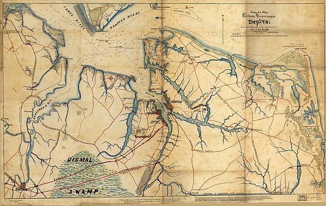
English: Map of the Hampton Roads vicinity showing Confederate fortifications/camps, settlements, city street patterns, roads, railroads, canals, streams, vegetation, and swamps. "Note--This map shows the positions of the rebel forces and their batteries as they were some six weeks since." Locates the "Minnesota 8 & 9 March 1862 on ground" and the "Monitor & Merrimac engagement on the 9th of March 1862". Relief shown by hachures. Depths shown by soundings and contours. In lower margin at left: For Maj. Gen'l Hitchcock, U.S. Vol., with the regards of T.J. Cram. Pen-and-ink (black/red) and watercolors (blue/green/orange). Imperfect: Fold-lined, torn at central fold line. LC Civil War maps (2nd ed.), 559 Available also through the Library of Congress Web site as a raster image. Includes text in lower margin and lengthy notes in map area. |
||
| Title | Copy of a map military reconnaissance Dep't Va. : [Hampton Roads and Norfolk regions, Va.] | ||
| Shelf ID | G3882.H3S5 1862 .W6 | ||
| Date | |||
| Source | https://www.loc.gov/item/2003630497/ | ||
| Author | Worret, Ch.; Cram, Thomas Jefferson; Hitchcock, Ethan Allen; United States. Army. Department Of Virginia | ||
| Permission (Reusing this file) |
|
||
| Other versions |
|
||
| Location | Hampton Roads Region · Region · Virginia · United States · Hampton Roads · Norfolk Region | ||
| Part of | Military Battles And Campaigns · American Memory · Civil War Maps · Catalog · Geography And Map Division | ||
| Subject | Maps, Manuscript · Hampton Roads, Battle Of, Va. · Norfolk Region (Va.) · Hampton Roads Region · Virginia · Civil War · United States · Maps · Hampton Roads, Battle Of, Va · Hampton Roads (Va. : Region) · Norfolk Region · History |


_LOC_2003630497.jpg&action=edit§ion=1)
Licensing[edit]
_LOC_2003630497.jpg&action=edit§ion=2)
|
This is a faithful photographic reproduction of a two-dimensional, public domain work of art. The work of art itself is in the public domain for the following reason:
The official position taken by the Wikimedia Foundation is that "faithful reproductions of two-dimensional public domain works of art are public domain".
This photographic reproduction is therefore also considered to be in the public domain in the United States. In other jurisdictions, re-use of this content may be restricted; see Reuse of PD-Art photographs for details. | ||||
File history
Click on a date/time to view the file as it appeared at that time.
| Date/Time | Thumbnail | Dimensions | User | Comment | |
|---|---|---|---|---|---|
| current | 14:24, 10 May 2018 | | 10,993 × 6,941 (11.17 MB) | Fæ (talk | contribs) | LOC Maps https://www.loc.gov/item/2003630497/ #8114 |
You cannot overwrite this file.
File usage on Commons
The following page uses this file:
_LOC_2003630497.jpg&oldid=868233510)