File:Corfu topographic map-en.svg
跳至導覽
跳至搜尋

此 SVG 檔案的 PNG 預覽的大小:537 × 600 像素。 其他解析度:215 × 240 像素 | 430 × 480 像素 | 688 × 768 像素 | 917 × 1,024 像素 | 1,834 × 2,048 像素 | 2,096 × 2,341 像素。
原始檔案 (SVG 檔案,表面大小:2,096 × 2,341 像素,檔案大小:2.19 MB)
說明
說明
添加單行說明來描述出檔案所代表的內容
![]()
Detailed map of large dimension. For a better viewing, click on the link of the image above.
Carte détaillée de grande dimension. Pour une visualisation optimale, cliquer sur le lien de l'image ci-dessus.
摘要
[編輯]| 描寫 |
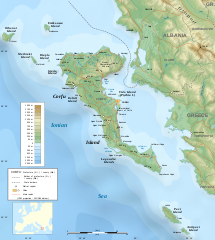
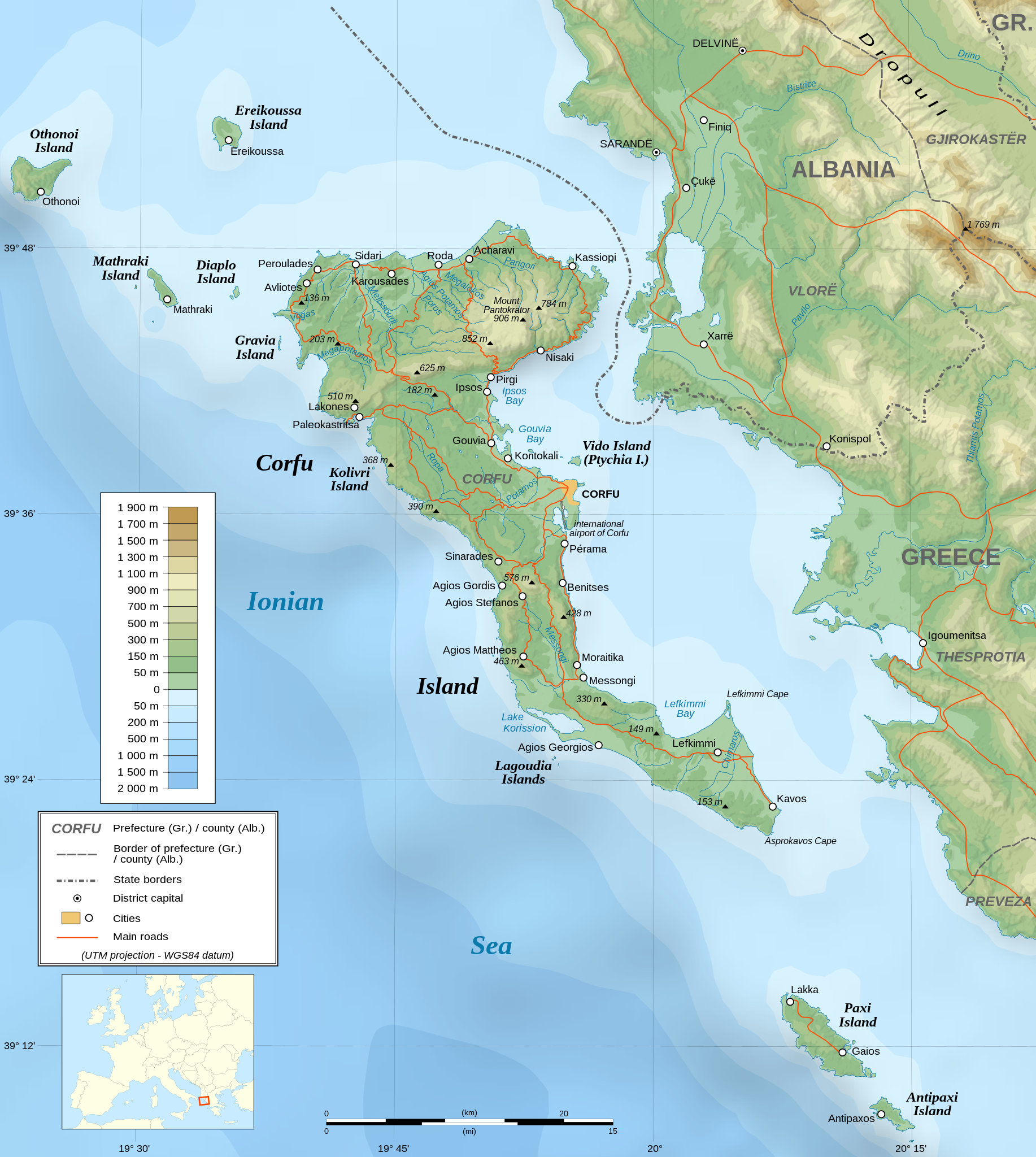
English: Topographic map in English of the Corfu island area in Greece.
Note : The shaded relief is a raster image embedded in the SVG file. Français : Carte topographique en anglais de la zone de l'île de Corfou en Grèce.
Note : Le relief ombré est une image bitmap embarquée dans le fichier SVG. UTM projection ; WGS84 datum ; shaded relief (composite image of N-W, W and N lightning positions) ;
|
||
| SVG開發 | 這個SVG 檔案使用了內置文字,可以使用任何文字編輯器輕鬆翻譯。 |
||
| 日期 | March 2007 (modified 09/2008) | ||
| 來源 |
Own work ;
|
||
| 創作作者 | |||
| 授權許可 (重用此檔案) |
|
||
| 地理參考 | 如果不合適,請設定「warp_status = skip」為隱藏。 | ||
| 其他版本 |
[]
|


授權條款
[編輯]我,本作品的著作權持有者,決定用以下授權條款發佈本作品:

|
已授權您依據自由軟體基金會發行的無固定段落、封面文字和封底文字GNU自由文件授權條款1.2版或任意後續版本,對本檔進行複製、傳播和/或修改。該協議的副本列在GNU自由文件授權條款中。 |
| 此檔案採用共享創意 姓名標示-相同方式分享 3.0 未在地化版本授權條款。 | ||
| ||
| 已新增授權條款標題至此檔案,作為GFDL授權更新的一部份。 |
您可以選擇您需要的授權條款。
評價
[編輯]
檔案歷史
點選日期/時間以檢視該時間的檔案版本。
| 日期/時間 | 縮圖 | 尺寸 | 用戶 | 備註 | |
|---|---|---|---|---|---|
| 目前 | 2021年8月24日 (二) 07:17 | | 2,096 × 2,341(2.19 MB) | Praça de Maio(對話 | 貢獻) | File uploaded using svgtranslate tool (https://svgtranslate.toolforge.org/). Added translation for tr. |
| 2014年10月29日 (三) 22:47 |  | 2,096 × 2,341(2.18 MB) | Ras67(對話 | 貢獻) | cropped | |
| 2008年9月4日 (四) 22:41 |  | 2,100 × 2,345(2.47 MB) | Sting(對話 | 貢獻) | Using bathymetry from ETOPO1 ; new standard colors | |
| 2007年10月29日 (一) 18:59 |  | 2,100 × 2,345(3.17 MB) | Sting(對話 | 貢獻) | "Pavllo" river name correction ; + river names on Corfu island ; key more complete | |
| 2007年5月16日 (三) 01:05 |  | 2,100 × 2,345(3.14 MB) | Sting(對話 | 貢獻) | International elevation key | |
| 2007年3月30日 (五) 01:07 |  | 2,100 × 2,345(3.14 MB) | Sting(對話 | 貢獻) | {{Information| |Description=Topographic map in French of the Corfu island area in Greece. |Source=Own work ;<br/>Background map : [http://www2.jpl.nasa.gov/srtm NASA Shuttle Radar Topography Mission] (SRTM3 v.2) (public domain) edited with [ |
無法覆蓋此檔案。
檔案用途
下列57個頁面有用到此檔案:
- Wikimedia Conference Japan 2009/Commons写真展
- User:Aristeas/check
- User:Giorgi Balakhadze/Gallery
- User:JoKalliauer/SVG test suites/Featured details
- User:Magog the Ogre/Multilingual legend/2021 August 21-31
- User:Miya/Introduction
- User:Pfctdayelise/POTY07 categories/2007 list
- User:SVGbot/Results
- User:Sting/Gallery: Regional maps
- User:Sting/Profile
- User talk:MapMaster
- User talk:Sting/Archive 01
- Commons:Bu proje sayfasının diğer dil sürümleri
- Commons:Conhece os nossos ilustradores
- Commons:Conoce a nuestros ilustradores
- Commons:Descobreix els nostres il.lustradors
- Commons:Descobrètz nòstres illustrators
- Commons:Découvrez nos illustrateurs
- Commons:Featured picture candidates/Image:Corfu topographic map-en.svg
- Commons:Featured picture candidates/Log/November 2007
- Commons:Featured pictures/Non-photographic media/Maps
- Commons:Featured pictures/chronological/2007-B
- Commons:Graphic Lab/Map workshop/Archive/2014
- Commons:Meet our illustrators
- Commons:Meet our illustrators/People
- Commons:Picture of the Year/2007/Galleries/All
- Commons:Picture of the Year/2007/Galleries/Graphic art and maps
- Commons:Picture of the Year/2007/Results/Round 1/Gallery
- Commons:Poznaj naszych grafików
- Commons:Scopri i nostri illustratori
- Commons:Scummigghia ê nostri llustratura
- Commons:Unsere Illustratoren stellen sich vor
- Commons:Unseri Illustratore stelle sich vor
- Commons:Upoznajte naše ilustratore
- Commons:Çizerlerimizle tanışın
- Commons:Запознајте ги нашите илустратори
- Commons:Знайомтесь з нашими ілюстраторами
- Commons:Знакомьтесь с нашими иллюстраторами
- Commons:قابل رسامينا
- Commons:私達のイラストレータをご紹介します
- Commons:结识我们的插图师
- Commons:우리들의 삽화가를 만나보세요
- Commons talk:Project Mapmaking Wiki Standards/Archive01
- File:Corfu topographic map-Stad.PNG
- File:Corfu topographic map-be.svg
- File:Corfu topographic map-blank.svg
- File:Corfu topographic map-de.svg
- File:Corfu topographic map-el.svg
- File:Corfu topographic map-en.svg
- File:Corfu topographic map-en librsvg.png
- File:Corfu topographic map-en rendersvg.png
- File:Corfu topographic map-es.svg
- File:Corfu topographic map-fr.svg
- File:Corfu topographic map-hu.svg
- File:Corfu topographic map-mk.svg
- File:Corfu topographic map-nb.svg
- Template:Other versions/Corfu topographic map
全域檔案使用狀況
以下其他 wiki 使用了這個檔案:
- af.wikipedia.org 的使用狀況
- bg.wikipedia.org 的使用狀況
- bn.wikipedia.org 的使用狀況
- bs.wikipedia.org 的使用狀況
- ca.wikipedia.org 的使用狀況
- de.wikipedia.org 的使用狀況
- en.wikipedia.org 的使用狀況
- es.wikipedia.org 的使用狀況
- fa.wikipedia.org 的使用狀況
- fi.wikipedia.org 的使用狀況
- fr.wikipedia.org 的使用狀況
- fy.wikipedia.org 的使用狀況
- gl.wikipedia.org 的使用狀況
- he.wikipedia.org 的使用狀況
- hu.wikipedia.org 的使用狀況
- hy.wikipedia.org 的使用狀況
- ia.wikipedia.org 的使用狀況
- id.wikipedia.org 的使用狀況
- is.wikipedia.org 的使用狀況
- it.wikipedia.org 的使用狀況
- it.wikivoyage.org 的使用狀況
- ja.wikipedia.org 的使用狀況
檢視此檔案的更多全域使用狀況。