File:County of Flanders (topogaphy).png
跳至導覽
跳至搜尋
預覽大小:706 × 599 像素。 其他解析度:283 × 240 像素 | 566 × 480 像素 | 760 × 645 像素。
原始檔案 (760 × 645 像素,檔案大小:190 KB,MIME 類型:image/png)
說明
說明
添加單行說明來描述出檔案所代表的內容
摘要
[編輯].png&action=edit§ion=1)
| 描述 |
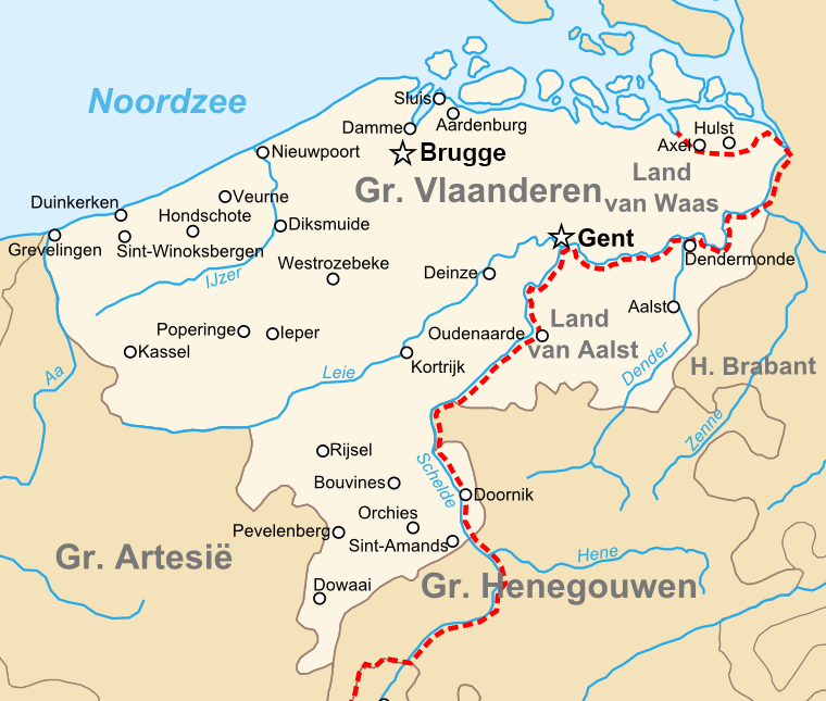
English: Map of the en:County of Flanders in the late 14th centry.
Nederlands: Kaart van het nl:Graafschap Vlaanderen in de Tweede helft van de 14e eeuw. |
| 日期 | 2008年6月10日 (上傳日期) |
| 來源 | 自己的作品 |
| 作者 | Sir Iain |
授權條款
[編輯].png&action=edit§ion=2)
| 我,此作品的版權所有人,釋出此作品至公共領域。此授權條款在全世界均適用。 這可能在某些國家不合法,如果是的話: 我授予任何人有權利使用此作品於任何用途,除受法律約束外,不受任何限制。 |
| 註解 | 該圖片含有註解:在維基媒體共享資源上查看註解 |
.png)
檔案歷史
點選日期/時間以檢視該時間的檔案版本。
| 日期/時間 | 縮圖 | 尺寸 | 使用者 | 備註 | |
|---|---|---|---|---|---|
| 目前 | 2023年1月22日 (日) 22:48 | | 760 × 645(190 KB) | Le Fou(留言 | 貢獻) | correction |
| 2008年6月10日 (二) 19:35 |  | 760 × 645(207 KB) | Sir Iain(留言 | 貢獻) | {{Information |Description={{en|1=Topographic map of the en:County of Flanders in the late 14th centry.}} {{nl|1=Topografische kaart van het nl:Graafschap Vlaanderen in de Tweede helft van de 14e eeuw.}} |Source=eigen werk (own work) |Author=[[U |
無法覆蓋此檔案。
檔案用途
全域檔案使用狀況
以下其他 wiki 使用了這個檔案:
- bn.wikipedia.org 的使用狀況
- cs.wikipedia.org 的使用狀況
- de.wikipedia.org 的使用狀況
- de.wiktionary.org 的使用狀況
- el.wikipedia.org 的使用狀況
- en.wikipedia.org 的使用狀況
- es.wikipedia.org 的使用狀況
- et.wikipedia.org 的使用狀況
- fr.wikipedia.org 的使用狀況
- he.wikipedia.org 的使用狀況
- id.wikipedia.org 的使用狀況
- it.wikipedia.org 的使用狀況
- nl.wikipedia.org 的使用狀況
- Ronse
- Graafschap Vlaanderen
- Rijks-Vlaanderen
- Kroon-Vlaanderen
- Land van Aalst
- Portaal:Middeleeuwen/Uitgelicht
- Portaal:Middeleeuwen/Uitgelicht/26
- Politieke geschiedenis van Vlaanderen
- Tijdlijn van de Lage Landen (steden en vorstendommen)
- Geschiedenis van de Habsburgse Nederlanden (1482-1556)
- Geschiedenis van de opkomst van vorstendommen en steden in de Lage Landen
- Geschiedenis van Oost-Vlaanderen
- Vliet (Antwerpen)
- sh.wikipedia.org 的使用狀況
- sl.wikipedia.org 的使用狀況
- vls.wikipedia.org 的使用狀況
- www.wikidata.org 的使用狀況
- zh.wikipedia.org 的使用狀況
.png&oldid=870204191)