File:Crete topographic map-it.svg
Jump to navigation
Jump to search

Size of this PNG preview of this SVG file: 800 × 380 pixels. Other resolutions: 320 × 152 pixels | 640 × 304 pixels | 1,024 × 486 pixels | 1,280 × 608 pixels | 2,560 × 1,215 pixels | 3,370 × 1,600 pixels.
Original file (SVG file, nominally 3,370 × 1,600 pixels, file size: 2.6 MB)
Captions
Captions
Add a one-line explanation of what this file represents
Summary[edit]
| Description | |
| Date | |
| Source |
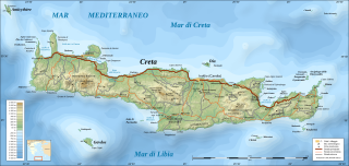
Own work ; Topography : NASA Shuttle Radar Topography Mission (SRTM3 v.2) data (public domain) edited with 3DEM and dlgv32 Pro and vectorized with Inkscape ; UTM projection ; WGS84 datum ; shaded relief (composite image of N-W, W and N lightning positions) ; Bathymetry : USGS ETOPO2v2 ; References used for the additional data : * Demis (see the approval e-mail and the Demis forum) ; * ViaMichelin ; * Map from Castello Hotels.com ; Locator map : Image:Map_Greece_expansion_1832-1947-fr.svg (modified) created by Historicair ; Translation of the Greek names into French : fr:Cédric Boissière and fr:Aeleftherios ; Approximate scales : * Topographic data and shore / lakes limits : 1:400,000 (accuracy : about 100 m) ; * Bathymetry : 1:14,800,000 (accuracy : about 3,700 m) ; Note : The shaded relief is a raster image embedded in the SVG file. |
| Author | Eric Gaba (Sting) |
| Permission (Reusing this file) |
Attribution and Share-Alike required |
| Other versions |
[]
|


| Camera location | | View this and other nearby images on: OpenStreetMap |
|---|

|
This SVG file contains embedded text that can be translated into your language, using any capable SVG editor, text editor or the SVG Translate tool. For more information see: About translating SVG files. |
Licensing[edit]
I, the copyright holder of this work, hereby publish it under the following licenses:

|
Permission is granted to copy, distribute and/or modify this document under the terms of the GNU Free Documentation License, Version 1.2 or any later version published by the Free Software Foundation; with no Invariant Sections, no Front-Cover Texts, and no Back-Cover Texts. A copy of the license is included in the section entitled GNU Free Documentation License. |
This file is licensed under the Creative Commons Attribution-Share Alike 4.0 International, 3.0 Unported, 2.5 Generic, 2.0 Generic and 1.0 Generic license.
- You are free:
- to share – to copy, distribute and transmit the work
- to remix – to adapt the work
- Under the following conditions:
- attribution – You must give appropriate credit, provide a link to the license, and indicate if changes were made. You may do so in any reasonable manner, but not in any way that suggests the licensor endorses you or your use.
- share alike – If you remix, transform, or build upon the material, you must distribute your contributions under the same or compatible license as the original.
You may select the license of your choice.
File history
Click on a date/time to view the file as it appeared at that time.
| Date/Time | Thumbnail | Dimensions | User | Comment | |
|---|---|---|---|---|---|
| current | 11:15, 3 March 2009 | | 3,370 × 1,600 (2.6 MB) | Kanchelskis (talk | contribs) | == Summary == {{Location|35|20|00|N|25|00|00|E|scale:2000000}} <br/> Translation of below: {{Information |Description={{en|Topographic map in Italian of Crete island, Greece.}} {{fr|Carte topographique en italienne de l'île |
You cannot overwrite this file.
File usage on Commons
The following 19 pages use this file:
- File:Crete archaeological sites-fr.svg
- File:Crete archaeological sites-pt.svg
- File:Crete integrated map-el.svg
- File:Crete integrated map-en.svg
- File:Crete integrated map-hu.svg
- File:Crete integrated map-mk.svg
- File:Crete integrated map-ur.svg
- File:Crete relief map-be.svg
- File:Crete relief map-de.jpg
- File:Crete relief map-de.svg
- File:Crete relief map-fr.svg
- File:Crete topographic map-fr.jpg
- File:Crete topographic map-fr.svg
- File:Crete topographic map-it.svg
- File:Crete topographic map-ru.svg
- File:Crete topographic map-uk.svg
- File:Greece (ancient) Crete (relief-cropped).png
- File:Minoan Crete topographic map-ru.svg
- Template:Other versions/Crete topographic map
_Crete_(relief-cropped).png)
File usage on other wikis
The following other wikis use this file:
- Usage on it.wikipedia.org
- Usage on lmo.wikipedia.org
- Usage on uk.wikipedia.org