File:Crichton SK plaque.jpg

Original file (4,608 × 3,456 pixels, file size: 6.64 MB, MIME type: image/jpeg)
Captions
Captions
Summary
[edit]
| Description |
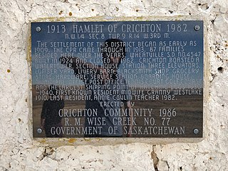
English: Plaque on monument at Crichton, Saskatchewan. Apologies for reflection. Text reads:
1913 Hamlet of Crichton 1982 N.W. 1/4 Sec. 8 Twp. 9 R. 14 W. 3rd M. The settlement of this district began as early as 1909. The CPR came through in 1913. 87 families resided here over the years. Wheatville S.D. No. 4547 built in 1924 and closed 1962. Crichton boasted a watertower, section house, station, three elevators, lumber yard, livery barn, blacksmith shop, grocery store, hardware, service station, boarding house, municipal office, post office, tennis court, golf course and the largest shipping point of hatching eggs 1930-1940. First known resident, midwife "Granny" Westlake 1910. Last resident, Annie Covlin teacher 1982. Erected by Crichton Community 1986 R.M. Wise Creek No. 77 Government of Saskatchewan |
| Date | 13 March 2021 (according to Exif data) |
| Source | Own work |
| Author | Awmcphee |
| Camera location | | View this and other nearby images on: OpenStreetMap |
|---|
Licensing
[edit]
- You are free:
- to share – to copy, distribute and transmit the work
- to remix – to adapt the work
- Under the following conditions:
- attribution – You must give appropriate credit, provide a link to the license, and indicate if changes were made. You may do so in any reasonable manner, but not in any way that suggests the licensor endorses you or your use.
- share alike – If you remix, transform, or build upon the material, you must distribute your contributions under the same or compatible license as the original.
| This file was uploaded via Mobile Android App (Commons mobile app) 2.13.2~757c7b008. |
File history
Click on a date/time to view the file as it appeared at that time.
| Date/Time | Thumbnail | Dimensions | User | Comment | |
|---|---|---|---|---|---|
| current | 02:03, 14 March 2021 | | 4,608 × 3,456 (6.64 MB) | Awmcphee (talk | contribs) | Uploaded using Commons Mobile App |
You cannot overwrite this file.
File usage on Commons
The following page uses this file: