File:Cuba and the Gulf of Batabanó (MODIS).jpg
Jump to navigation
Jump to search
Size of this preview: 730 × 599 pixels. Other resolutions: 292 × 240 pixels | 585 × 480 pixels | 936 × 768 pixels | 1,247 × 1,024 pixels | 2,223 × 1,825 pixels.
Original file (2,223 × 1,825 pixels, file size: 538 KB, MIME type: image/jpeg)
Captions
Captions
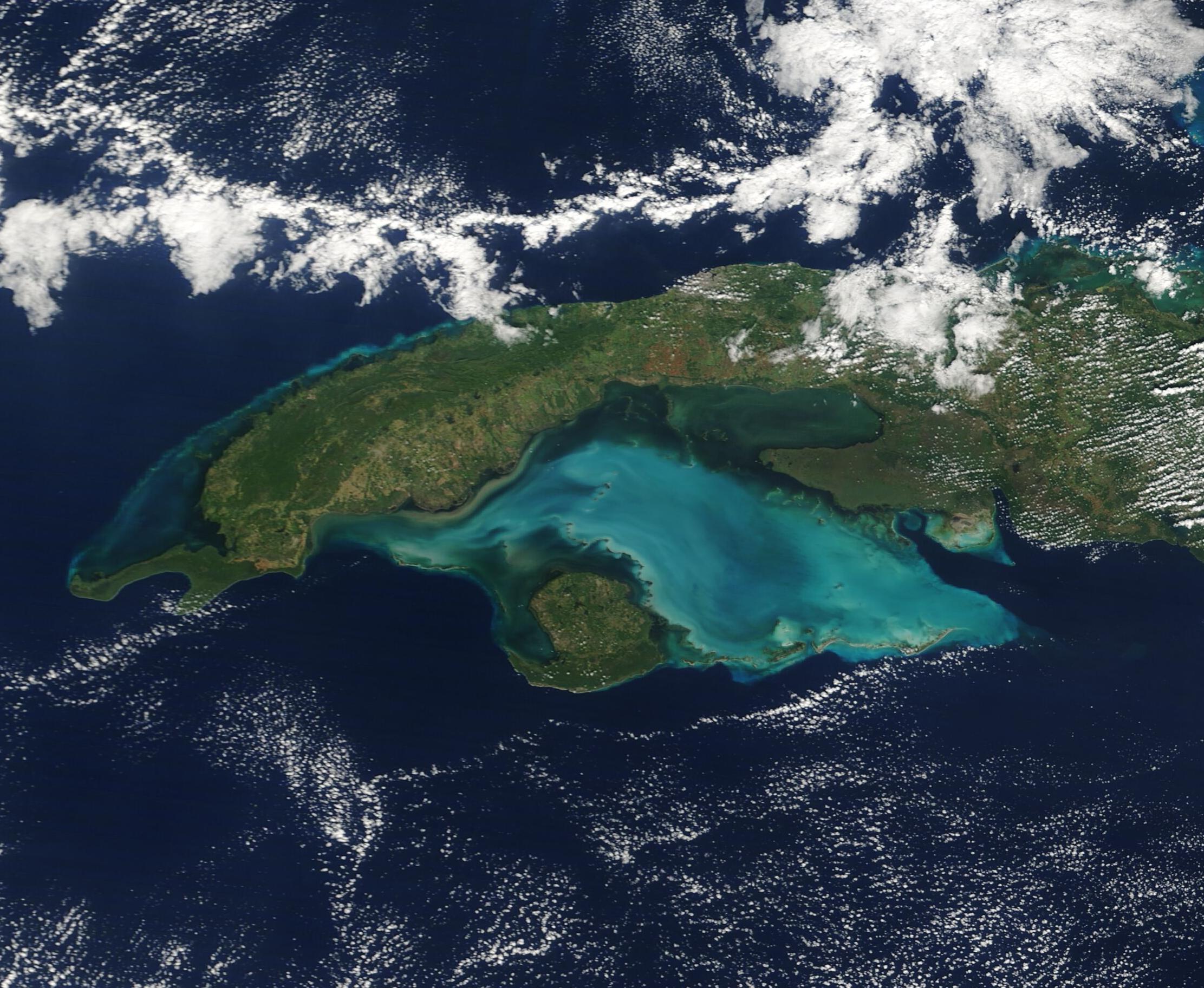
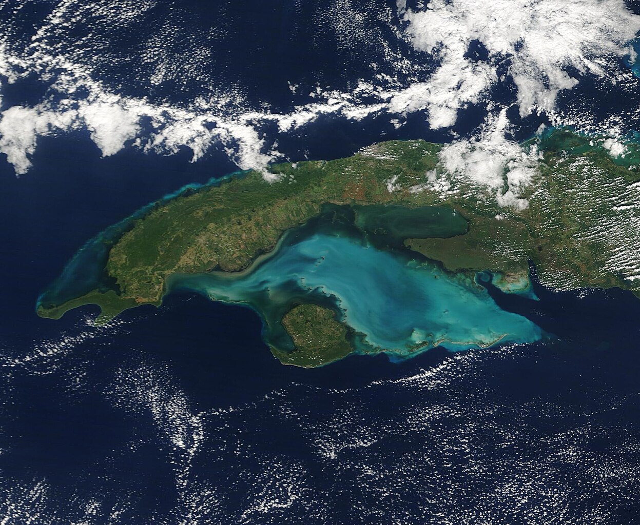
The glorious, jewel-toned waters of the Gulf of Batabanó highlight this true-color image of western Cuba which was acquired by the Moderate Resolution Imaging Spectroradiometer (MODIS) on board NASA’s Terra satellite on December 6, 2022.
Summary[edit]
.jpg&action=edit§ion=1)
| Description |
English: The glorious, jewel-toned waters of the Gulf of Batabanó highlight this true-color image of western Cuba which was acquired by the Moderate Resolution Imaging Spectroradiometer (MODIS) on board NASA’s Terra satellite on December 6, 2022.
Cuba is the largest island in the Caribbean, stretching about 750 miles (1,207 km) in length and measuring about 60 miles (97 km) wide on average. A curved shape with numerous peninsulas and inlets brings the island a remarkable 2,300 miles (3,700 km) of coastline. From space, the most outstanding feature associated with Cuba is the Gulf of Batabanó, a shallow inlet of the Caribbean Sea. The Gulf has a surface area of about 20,850 square kilometers (8,050 square miles), which is a slightly larger surface area of the U.S. state of Massachusetts, and an average depth of only 6 meters (19.6 feet). The typically turquoise waters sit over a carbonate bank, and this white, sandy bottom sediment can be easily stirred up by currents, tides, or wind-driven wave action. Wherever carbonate sediment is stirred up, the waters of the Gulf of Batabanó take on a milky tinge, as seen in this image. |
||
| Date | Taken on 6 December 2022 | ||
| Source |
Cuba and the Gulf of Batabanó (direct link)
|
||
| Author | MODIS Land Rapid Response Team, NASA GSFC |
| This media is a product of the Terra mission Credit and attribution belongs to the mission team, if not already specified in the "author" row |
Licensing[edit]
.jpg&action=edit§ion=2)
| This file is in the public domain in the United States because it was solely created by NASA. NASA copyright policy states that "NASA material is not protected by copyright unless noted". (See Template:PD-USGov, NASA copyright policy page or JPL Image Use Policy.) | ||
 |
Warnings:
|
File history
Click on a date/time to view the file as it appeared at that time.
| Date/Time | Thumbnail | Dimensions | User | Comment | |
|---|---|---|---|---|---|
| current | 12:29, 15 August 2023 | | 2,223 × 1,825 (538 KB) | OptimusPrimeBot (talk | contribs) | #Spacemedia - Upload of http://modis.gsfc.nasa.gov/gallery/images/image12082022_250m.jpg via Commons:Spacemedia |
You cannot overwrite this file.
File usage on Commons
There are no pages that use this file.
File usage on other wikis
The following other wikis use this file:
- Usage on fr.wikipedia.org
.jpg&oldid=818808086)