File:Cyclone Fakir off Madagascar (MODIS 2018-04-29).jpg

Original file (7,256 × 7,664 pixels, file size: 5.93 MB, MIME type: image/jpeg)
Captions
Captions
Summary
[edit].jpg&action=edit§ion=1)
| Description |
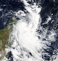
English: A short-lived, late-season tropical cyclone made a brief appearance off of Madagascar from April 23-25, 2018. The Moderate Resolution Imaging Spectroradiometer (MODIS) aboard NASA’s Terra satellite acquired a true-color image of the forming storm on April 23 as it gathered strength off of the northeastern coast of Madagascar. The storm was given the name Fakir on that same day.
According to the Joint Typhoon Warning Center (JTWC), at 1500 UTC (11:00 a.m. EDT), Fakir had maximum sustained winds of 46 mph (75 km/h) and the center was located near 6.5 degrees south latitude and 53.2 east longitude, or about 360 miles (579 km) north-northwest of St. Denis, la Reunion. Fakir was moving southeastward. The report noted “Satellite imagery depicts a rapidly consolidating system with improved deep convective banding wrapping into a well-defined low-level circulation center. Another image showed tightly-curved banding wrapping into a microwave eye feature." The storm continued to strengthen on April 24 but quickly began to be affected by strong wind shear. Maximum sustained winds reached about 74.6 mph 120 km/h), nudging it to tropical cyclone strength before it began to dissipate. The center of Tropical Cyclone Fakir passed close to the island la Reunion, drenching the small island with torrential rain. Flooding and mudslides have been reported, even though there was no direct hit. By April 25 Fakir was quickly dissipating with no additional threat to land noted. The southwest Indian Ocean cyclone season started on November 15, 2017 and will officially end on April 30, 2018. |
||
| Date | Taken on 23 April 2018 | ||
| Source |
Cyclone Fakir off Madagascar (direct link)
|
||
| Author | Jeff Schmaltz, MODIS Land Rapid Response Team, NASA GSFC |
| This media is a product of the Terra mission Credit and attribution belongs to the mission team, if not already specified in the "author" row |
Licensing
[edit].jpg&action=edit§ion=2)
| This file is in the public domain in the United States because it was solely created by NASA. NASA copyright policy states that "NASA material is not protected by copyright unless noted". (See Template:PD-USGov, NASA copyright policy page or JPL Image Use Policy.) | ||
 |
Warnings:
|
File history
Click on a date/time to view the file as it appeared at that time.
| Date/Time | Thumbnail | Dimensions | User | Comment | |
|---|---|---|---|---|---|
| current | 01:47, 17 February 2024 | | 7,256 × 7,664 (5.93 MB) | OptimusPrimeBot (talk | contribs) | #Spacemedia - Upload of http://modis.gsfc.nasa.gov/gallery/images/image04292018_250m.jpg via Commons:Spacemedia |
You cannot overwrite this file.
File usage on Commons
There are no pages that use this file.
.jpg&oldid=852713901)