File:Cyclone Indlala 2007.jpg

Original file (4,400 × 5,000 pixels, file size: 5.92 MB, MIME type: image/jpeg)
Captions
Captions
Summary[edit]
| DescriptionCyclone Indlala 2007.jpg |
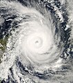
On March 14, 2007, storm-weary Madagascar braced for its fourth land-falling tropical cyclone in as many months. Cyclone Indlala was hovering off the island’s northeast coast when the Moderate Resolution Imaging Spectroradiometer (MODIS) on NASA’s Aqua satellite captured this photo-like image at 1:40 p.m. local time (10:40 UTC). Just over a hundred kilometers offshore, the partially cloudy eye at the heart of the storm seems like a vast drain sucking in a disk of swirling clouds. According to reports from the Joint Typhoon Warning Center issued less than three hours after MODIS captured this image, Indlala had winds of 115 knots (132 miles per hour), with gusts up to 140 knots (161 mph). Wave heights were estimated to be 36 feet. At the time of the report, the storm was predicted to intensify through the subsequent 12-hour period, to turn slightly southwest, and to strike eastern Madagascar as a Category 4 storm with sustained winds up to 125 knots (144 mph), and gusts up to 150 knots (173 mph). According to Reuters AlertNet news service, Madagascar’s emergency response resources were taxed to their limit in early March 2007 as a result of extensive flooding in the North, drought and food shortages in the South, and three previous hits from cyclones in the preceding few months: Bondo in December 2006, Clovis in January 2007, and Gamede in February. |
||||||
| Date | |||||||
| Source | http://earthobservatory.nasa.gov/IOTD/view.php?id=7493 | ||||||
| Author | NASA image by Jeff Schmaltz, MODIS Rapid Response Team, Goddard Space Flight Center. | ||||||
| Permission (Reusing this file) |
|
||||||
| Other versions | Image:Indlala 14 mar 2007 1040Z.jpg |
File history
Click on a date/time to view the file as it appeared at that time.
| Date/Time | Thumbnail | Dimensions | User | Comment | |
|---|---|---|---|---|---|
| current | 10:53, 31 July 2023 |  | 4,400 × 5,000 (5.92 MB) | Nino Marakot (talk | contribs) | Reverted to version as of 06:39, 22 March 2007 (UTC) |
| 06:51, 27 April 2019 |  | 5,600 × 7,200 (5.51 MB) | Nino Marakot (talk | contribs) | Reverted to version as of 09:06, 16 March 2007 (UTC) - original | |
| 04:26, 16 April 2013 |  | 5,120 × 7,200 (4.64 MB) | Earth100 (talk | contribs) | Best Image | |
| 06:39, 22 March 2007 |  | 4,400 × 5,000 (5.92 MB) | Coredesat (talk | contribs) | ||
| 09:06, 16 March 2007 |  | 5,600 × 7,200 (5.51 MB) | Coredesat (talk | contribs) | {{Information |Description=Intense Tropical Cyclone Indlala near peak intensity on March 14, 2007. The cyclone would make landfall in Madagascar early the next day. |Source=[http://rapidfire.sci.gsfc.nasa.gov/gallery/?2007073-0314 |
You cannot overwrite this file.
File usage on Commons
The following page uses this file:
File usage on other wikis
The following other wikis use this file:
- Usage on de.wikipedia.org
- Usage on fr.wikipedia.org
- Usage on ja.wikipedia.org
- Usage on pt.wikipedia.org
- Usage on zh.wikipedia.org
Metadata
This file contains additional information such as Exif metadata which may have been added by the digital camera, scanner, or software program used to create or digitize it. If the file has been modified from its original state, some details such as the timestamp may not fully reflect those of the original file. The timestamp is only as accurate as the clock in the camera, and it may be completely wrong.
| Orientation | Normal |
|---|---|
| Horizontal resolution | 72 dpi |
| Vertical resolution | 72 dpi |
| Software used | Adobe Photoshop 7.0 |
| File change date and time | 02:36, 22 March 2007 |
| Color space | Uncalibrated |

