File:Czechoslovakia Poland Border adjustments 1919-1945 ES.svg
Jump to navigation
Jump to search

Size of this PNG preview of this SVG file: 800 × 323 pixels. Other resolutions: 320 × 129 pixels | 640 × 259 pixels | 1,024 × 414 pixels | 1,280 × 517 pixels | 2,560 × 1,034 pixels | 1,000 × 404 pixels.
Original file (SVG file, nominally 1,000 × 404 pixels, file size: 52 KB)
Captions
Captions
Add a one-line explanation of what this file represents
| Description |
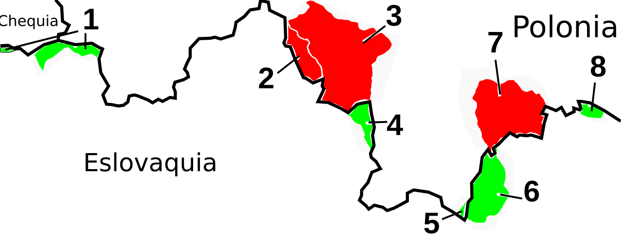
English: Map of Slovakia with border-changes in the north against Poland
Polski: Mapa przedstawiająca zmiany przebiegu granicy między dzisiejszymi Polską i Słowacją w pierwszej połowie XX wieku, wykonana 15 kwietnia 2006 roku. Legenda
Español: Mapa de Eslovaquia con los cambios fronterizos respecto a Polonia.
|
| Date | (UTC) |
| Source | |
| Author |
|
| This is a retouched picture, which means that it has been digitally altered from its original version. Modifications: Spanish version.. The original can be viewed here: Czechoslovakia Poland Border adjustments 1919-1945.svg:
|
I, the copyright holder of this work, hereby publish it under the following licenses:
This file is licensed under the Creative Commons Attribution-Share Alike 2.5 Generic, 2.0 Generic and 1.0 Generic license.
- You are free:
- to share – to copy, distribute and transmit the work
- to remix – to adapt the work
- Under the following conditions:
- attribution – You must give appropriate credit, provide a link to the license, and indicate if changes were made. You may do so in any reasonable manner, but not in any way that suggests the licensor endorses you or your use.
- share alike – If you remix, transform, or build upon the material, you must distribute your contributions under the same or compatible license as the original.
| This file is licensed under the Creative Commons Attribution-Share Alike 3.0 Unported license. | ||
| ||
| This licensing tag was added to this file as part of the GFDL licensing update. |

|
Permission is granted to copy, distribute and/or modify this document under the terms of the GNU Free Documentation License, Version 1.2 or any later version published by the Free Software Foundation; with no Invariant Sections, no Front-Cover Texts, and no Back-Cover Texts. A copy of the license is included in the section entitled GNU Free Documentation License. |
You may select the license of your choice.
Original upload log[edit]
This image is a derivative work of the following images:
- File:Czechoslovakia_Poland_Border_adjustments_1919-1945.svg licensed with Cc-by-sa-2.5,2.0,1.0, Cc-by-sa-3.0-migrated, GFDL
- 2009-05-31T05:16:55Z Esemono 1000x404 (123822 Bytes) move poland over
- 2009-05-31T01:40:16Z Esemono 1000x404 (123822 Bytes) {{Information |Description='''English:''' *map of Slovakia with border-changes in the north against Poland *selfprovided on April 15th, 2006 *1 - Skalité territories, from 2 October 1938 - 21 November 1939 to Poland *2 - Lip
Uploaded with derivativeFX
File history
Click on a date/time to view the file as it appeared at that time.
| Date/Time | Thumbnail | Dimensions | User | Comment | |
|---|---|---|---|---|---|
| current | 10:44, 2 January 2010 | 1,000 × 404 (52 KB) | Rowanwindwhistler (talk | contribs) | {{Information |Description={{en|1=*map of Slovakia with border-changes in the north against Poland *selfprovided on April 15th, 2006 *1 - Skalité territories, from 2 October 1938 - 21 November 1939 to Poland *2 - Lipnica Wielka territories, from 1918 |
You cannot overwrite this file.
File usage on Commons
The following page uses this file:
File usage on other wikis
The following other wikis use this file:
- Usage on es.wikipedia.org
Categories:
- Czech Republic-Slovakia border
- Maps of conflicts
- Maps of the Czechoslovak Republic (1918-1938)
- Eastern Front (World War II)
- History of Slovakia
- Maps of Nazi Germany
- Maps of the military history of Poland
- Wars of Germany
- Wars of Poland
- Spanish-language SVG maps showing history of Europe
- Maps of the Czechoslovak Republic (1938–1939)
- SVG maps of Czechoslovakia