File:DC Metro Map 2013.svg
跳转到导航
跳转到搜索

此SVG文件的PNG预览的大小:566 × 599像素。 其他分辨率:227 × 240像素 | 453 × 480像素 | 726 × 768像素 | 967 × 1,024像素 | 1,935 × 2,048像素 | 1,539 × 1,629像素。
原始文件 (SVG文件,尺寸为1,539 × 1,629像素,文件大小:4.48 MB)
说明
说明
添加一行文字以描述该文件所表现的内容
摘要
[编辑]| 描述 |
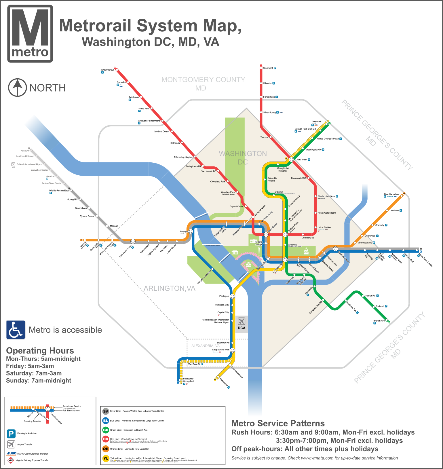
English: A redesigned map of the Washington Metro. Created using Adobe Illustrator. This map shows the Rush Plus service details and is designed to be more geographically matched than the current metro map. Two files from Commons were used in the creation of the Map. They are File:WMATA Metro Logo.svg, and File: Amtrak logo.svg |
| 日期 | |
| 来源 | 自己的作品 |
| 作者 | VeggieGarden |
本矢量图由v使用Adobe Illustrator创作.

许可协议
[编辑]
我,本作品著作权人,特此采用以下许可协议发表本作品:
| 本作品采用知识共享CC0 1.0 通用公有领域贡献许可协议授权。 | |
| 采用本宣告发表本作品的人,已在法律允许的范围内,通过在全世界放弃其对本作品拥有的著作权法规定的所有权利(包括所有相关权利),将本作品贡献至公有领域。您可以复制、修改、传播和表演本作品,将其用于商业目的,无需要求授权。
|
文件历史
点击某个日期/时间查看对应时刻的文件。
| 日期/时间 | 缩略图 | 大小 | 用户 | 备注 | |
|---|---|---|---|---|---|
| 当前 | 2015年12月3日 (四) 17:31 | | 1,539 × 1,629(4.48 MB) | Pi.1415926535(留言 | 贡献) | Reduce height |
| 2015年12月3日 (四) 17:27 |  | 1,539 × 1,779(4.47 MB) | Pi.1415926535(留言 | 贡献) | Fixed misaligned background | |
| 2015年12月2日 (三) 22:11 |  | 1,539 × 1,779(4.47 MB) | Pi.1415926535(留言 | 贡献) | Update station names | |
| 2015年12月2日 (三) 21:24 |  | 1,539 × 1,779(4.48 MB) | Pi.1415926535(留言 | 贡献) | Increase width for better visibility (no other changes) | |
| 2014年8月19日 (二) 09:23 |  | 512 × 592(4.09 MB) | Rcsprinter123(留言 | 贡献) | Cemetery, Mongomery | |
| 2013年10月18日 (五) 02:06 |  | 512 × 592(3.98 MB) | VeggieGarden(留言 | 贡献) | Added parking at Wiehle-Reston East Station, fixed "accessible" spelling error | |
| 2013年10月16日 (三) 23:56 |  | 512 × 592(3.86 MB) | VeggieGarden(留言 | 贡献) | Fixed More Errors, made the map more readable | |
| 2013年10月16日 (三) 23:56 |  | 512 × 592(3.86 MB) | VeggieGarden(留言 | 贡献) | Fixed More Errors, made the map more readable | |
| 2013年10月16日 (三) 23:43 |  | 512 × 592(586 KB) | VeggieGarden(留言 | 贡献) | Fixed errors | |
| 2013年10月16日 (三) 23:35 |  | 512 × 592(284 KB) | VeggieGarden(留言 | 贡献) | Brand New design, more accurate, addition of Silver Line Phase 1. The map is also easier to understand. |
您不可以覆盖此文件。
文件用途
以下2个页面使用本文件:
全域文件用途
以下其他wiki使用此文件:
- en.wikipedia.org上的用途
- pt.wikipedia.org上的用途
- zh.wikipedia.org上的用途