File:DOP40 - Gymnasium Gaimersheim (Bayerische Vermessungsverwaltung).tif
Jump to navigation
Jump to search

Size of this JPG preview of this TIF file: 800 × 545 pixels. Other resolutions: 320 × 218 pixels | 640 × 436 pixels | 1,024 × 698 pixels | 1,161 × 791 pixels.
Original file (1,161 × 791 pixels, file size: 1.49 MB, MIME type: image/tiff)
Captions
Captions
Add a one-line explanation of what this file represents
Summary
[edit]| Description |
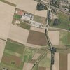
Deutsch: Ansicht eines digitalen Orthofotos von der Bayerischen Vermessungsverwaltung. Das Bild ist ein entzerrtes, maßstabsgetreues Luftbild auf Grundlage der Bayernbefliegung. Die Abmessungen dieses Bildes betragen 1 km × 1 km. Eine Pixelkante ist 40cm lang. Als Koordinatensystem wird UTM32, bzw. EPSG:25832 benutzt. Diese Datei ist die originale TIF-Datei von der Bayerischen Vermessungsverwaltung und wird als GEOTIFF bezeichnet. Die Aktualisierung der Grafiken erfolgt losweise, jedoch ist das Bild als aktuell anzusehen. Die DOP40-Bilder der Bayerischen Vermessungsverwaltung sind urheberrechtlich geschützt, OpenData und unter den Bedingungen der CC-BY-4.0-Lizenz nutzbar. Dieser Abschnitt zeigt einen Teil des Landkreises Eichstätt von oben.
English: View of a digital orthophoto from the Bavarian Survey Administration. The image is a rectified, scaled aerial photo based on the Bavarian survey. The dimensions of this image are 1km × 1km. One pixel edge is 40cm long. The coordinate system used is UTM32, or EPSG:25832. This file is the original TIF file from the Bavarian Survey Administration and is called GEOTIFF. The graphics are updated in batches, but should be considered current. The DOP40 images from the Bavarian Survey Administration are copyrighted, OpenData, and usable under the terms of the CC-BY 4.0 license. This section shows a part of the district of Eichstätt from above. |
| Date | |
| Source |
|
| Author | Bayerische Vermessungsverwaltung – www.geodaten.bayern.de |
| Other versions |
| Camera location | | View this and other nearby images on: OpenStreetMap |
|---|
Licensing
[edit]This file is licensed under the Creative Commons Attribution 4.0 International license.
- You are free:
- to share – to copy, distribute and transmit the work
- to remix – to adapt the work
- Under the following conditions:
- attribution – You must give appropriate credit, provide a link to the license, and indicate if changes were made. You may do so in any reasonable manner, but not in any way that suggests the licensor endorses you or your use.
File history
Click on a date/time to view the file as it appeared at that time.
| Date/Time | Thumbnail | Dimensions | User | Comment | |
|---|---|---|---|---|---|
| current | 21:59, 22 November 2023 |  | 1,161 × 791 (1.49 MB) | Derkoenig (talk | contribs) | File:DOP40 - Landkreis Eichstätt 32673 5407 (Bayerische Vermessungsverwaltung).tif cropped 54 % horizontally, 68 % vertically using CropTool with precise mode. |
You cannot overwrite this file.
File usage on Commons
The following page uses this file:
File usage on other wikis
The following other wikis use this file:
- Usage on de.wikipedia.org