File:Dachstuhl des Rathauses Hof 20231125 HOF02704-HDR RAW-Export.png
Jump to navigation
Jump to search

Size of this preview: 800 × 533 pixels. Other resolutions: 320 × 213 pixels | 640 × 427 pixels | 1,024 × 683 pixels | 1,280 × 853 pixels | 2,560 × 1,707 pixels | 9,504 × 6,336 pixels.
Original file (9,504 × 6,336 pixels, file size: 65.33 MB, MIME type: image/png)
Captions
Captions
Add a one-line explanation of what this file represents
Summary
[edit]
| Description |
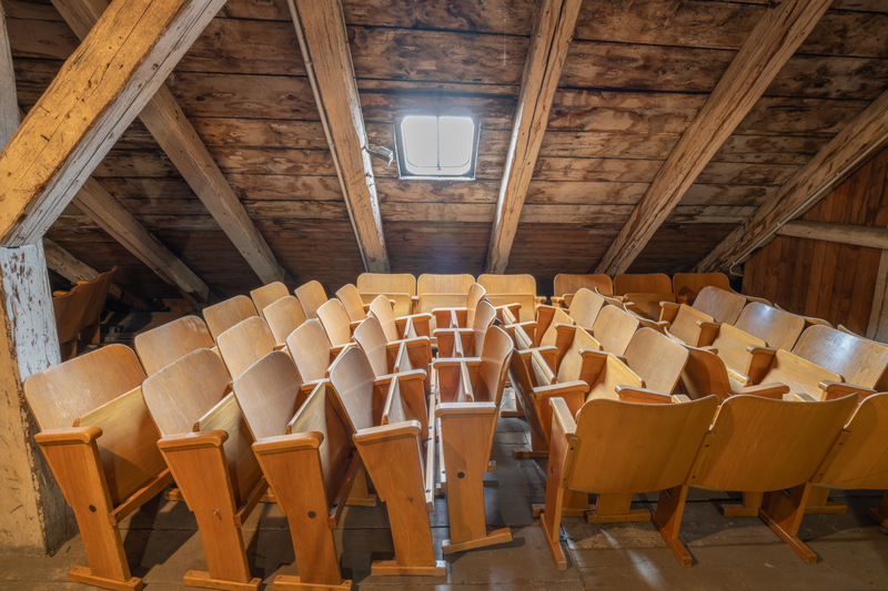
Deutsch: Dachstuhl des Rathauses Hof. Der Dachstuhl bietet zwei größere Ebenen im Hauptgebäude des Rathauses. In der oberen Ebene kann man die Holzbalken zum Dachfirst zusammenlaufen sehen. Während des Aufenthalts am Dach hat man mysteriöse und teils "gruselige" Geräusche gehört. Ein Teil stammt wohl von vom Dach herabfallenden Schnee. Auf dem unteren Teil des Dachstuhls sieht man Vorrichtungen zur Stabilisierung des Daches und Rohre, Schächte und mehr. Aber es werden auch Dinge abgelegt, die teils historisch sind. Die Fotos entstanden in freundlicher Kooperation mit der Stadtverwaltung von Hof. Der Fotograf (ich) hat es versäumt, die Kamerauhr auf Winterzeit umzustellen. Deshalb ist die Uhrzeit der Fotografie um eine Stunde zu reduzieren. Hier sieht man außer Betrieb gesetzte Stühle, die möglicherweise weggeworfen werden.
English: Roof truss of the Hof town hall. The roof truss offers two larger levels in the main building of the town hall. On the upper level, you can see the wooden beams running together to form the roof ridge. During the visit to the roof, mysterious and sometimes "creepy" noises were heard. Some of it was probably caused by snow falling from the roof. On the lower part of the roof truss, you can see devices for stabilizing the roof, pipes, shafts and more. But there are also things on display, some of which are historical. The photos were taken in friendly cooperation with the city administration of Hof. The photographer (me) neglected to change the camera clock to winter time. Therefore the time of the photograph has to be reduced by one hour. Here you can see chairs that have been taken out of service and may be thrown away. |
| Date | |
| Source | Own work |
| Author | PantheraLeo1359531 |
| Camera location | | View this and other nearby images on: OpenStreetMap |
|---|
Ein Lizenzhinweis für eine Wiederverwendung des Fotos kann unter folgendem Hyperlink generiert werden: https://lizenzhinweisgenerator.de/
Licensing
[edit]
I, the copyright holder of this work, hereby publish it under the following license:
This file is licensed under the Creative Commons Attribution 4.0 International license.
- You are free:
- to share – to copy, distribute and transmit the work
- to remix – to adapt the work
- Under the following conditions:
- attribution – You must give appropriate credit, provide a link to the license, and indicate if changes were made. You may do so in any reasonable manner, but not in any way that suggests the licensor endorses you or your use.
File history
Click on a date/time to view the file as it appeared at that time.
| Date/Time | Thumbnail | Dimensions | User | Comment | |
|---|---|---|---|---|---|
| current | 16:52, 4 December 2023 | | 9,504 × 6,336 (65.33 MB) | PantheraLeo1359531 (talk | contribs) | c:User:Rillke/bigChunkedUpload.js: SDR-Ausgabe |
| 16:09, 4 December 2023 |  | 9,477 × 6,318 (60.28 MB) | PantheraLeo1359531 (talk | contribs) | Uploaded own work with UploadWizard |
You cannot overwrite this file.
File usage on Commons
There are no pages that use this file.